
Hide
Barnetby le Wold
hide
Hide
hide
Hide
hide
Hide
Hide
hide
Hide
Hide
The Brigg Library is an excellent resource with a Local History section.
- In the August 2000 Journal of the LFHS there's a review of a book "All Things Forgotten ....Village Life in Barnetby in the 16th & 17th Centuries." The book was written by Neil R. WILKYN and students at the Barnetby W.E.A. 190 pages, A4 size, ISBN 09536-13003, £9.99 (plus £2.95 p.& p.), available from the author at 48 Railway Street, Barnetby-le-Wold, North Lincs. DN38 6DQ.
- The Lincolnshire Archives have an 1821 census return (surnames only) for Barnetby.
- We have an index of folio numbers and surnames from the 1901 Census in a text file for your use. Your corrections and additions are welcome.
- Check our Census Resource page for county-wide resources.
- The table below gives census piece numbers, where known:
| Census Year | Piece No. |
|---|---|
| 1841 | H.O. 107 / 627 |
| 1851 | H.O. 107 / 2116 |
| 1861 | R.G. 9 / 2399 |
| 1871 | R.G. 10 / 3430 |
| 1891 | R.G. 12 / 2626 |
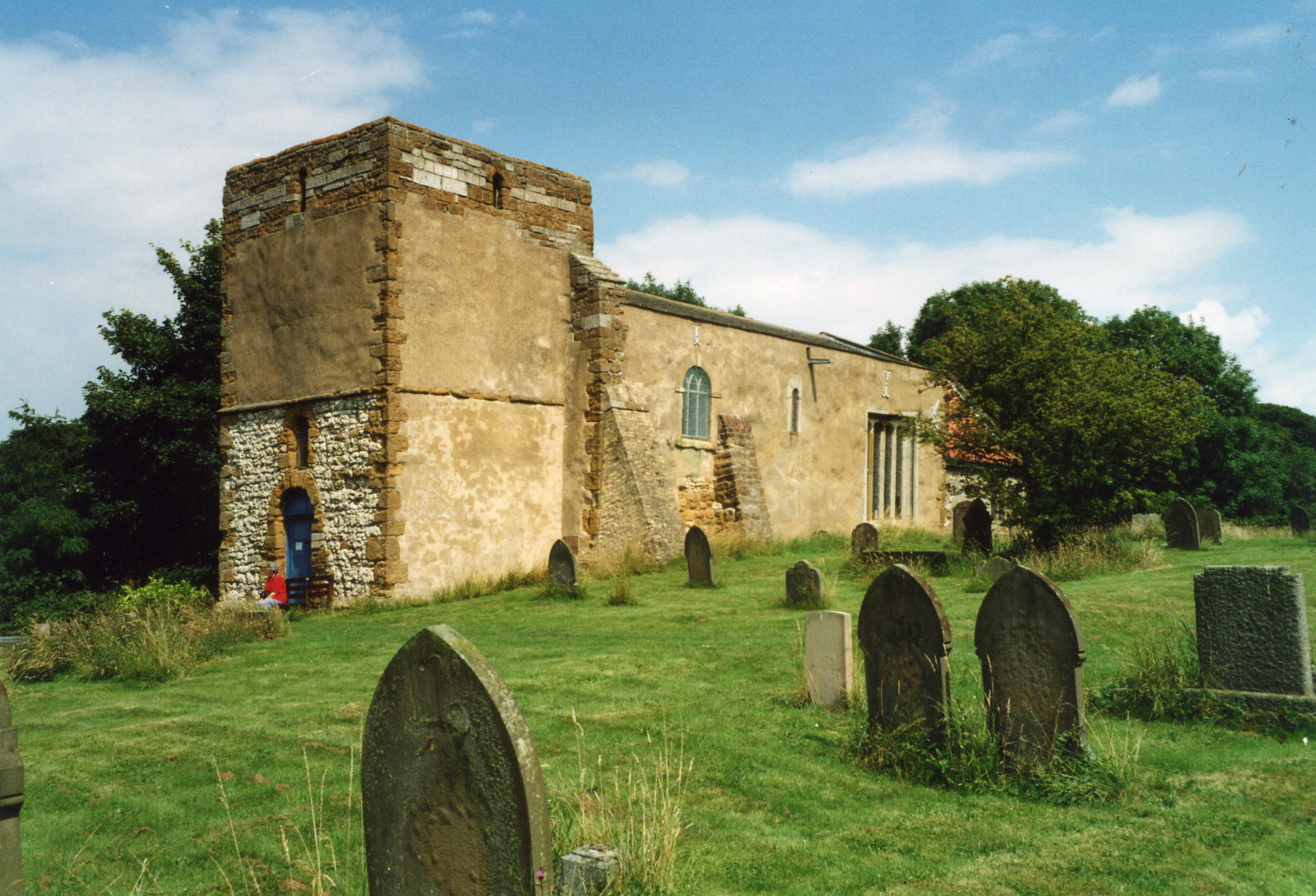
- After the Norman Conquest, a church was built on the hillside just above the village, consecrated to Saint Mary.
- The present church is built on the site of this earlier church. The south wall was part of this earlier, Saxon church.
- The church consists of an aisleless nave and chancel.
- The font in St. Mary's church is said to date from the reign of King Stephen.
- The church seats 270.
- The Diocese of Lincoln declared St. Mary's Church redundant in October, 1972.
- There is a photograph of the Anglican parish church on the Wendy PARKINSON Church Photos web site.
- Here is a photograph of St. Mary's, taken by Ron COLE (who retains the copyright):
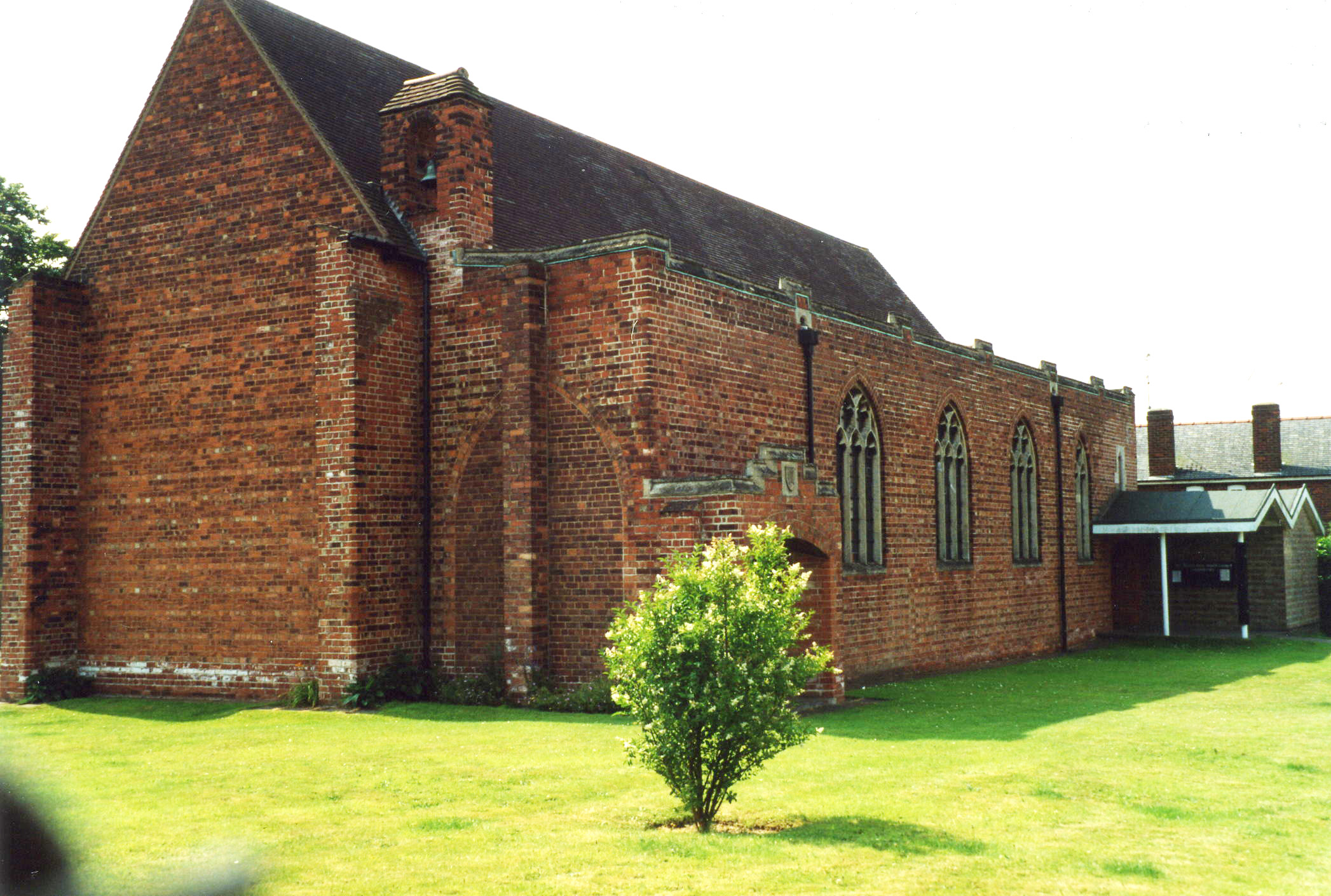
- The new church is dedicated to Saint Barnabas.
- St. Barnabas Church was opened in 1927.
- David WRIGHT has a photograph of St. Barnabas Church on Geo-graph, taken in February, 2006.
- Here is a photograph of St. Barnabas Church, taken by Ron COLE (who retains the copyright):
- The Anglican parish registers for St. Mary's exist from 1753, although entries in the IGI go back to 1561.
- We have the beginnings of a Parish Register Extract in a text file for your use. Your corrections and additions are welcome.
- The Lincolnshire FHS has published several marriage indexes and a burial index for the Yarborough Deanery to make your search easier.
- There were also chapels for Wesleyan Methodists, built in 1879, and Primitive Methodists, built in 1855 and rebuilt in 1893. The Independents also had a chapel here. For more on researching these chapel records, see our non-conformist religions page.
- Check our Church Records page for county-wide resources.
- David WRIGHT has a photograph of the Barnetby Methodist Church on Geo-graph, taken in August, 2006.
- The parish was in the Brigg sub-district of the Glanford Brigg Registration District.
- Check our Civil Registration page for sources and background on Civil Registration beginning in July, 1837.
Barnetby le Wold is a village and parish, due south of Barton upon Humber and due east of Scunthorpe, about ten miles from the Humberside International Airport. The parish covers about 2,580 acres and includes the hamlet of New Barnetby.
If you are planning a visit:
- The village is located just south of the intersection of the A15 and M180 Motorway.
- See our touring page for visitor services.
- Ask for a calculation of the distance from Barnetby le Wold to another place.
- Archaeologists examining a housing development site at Barnetby uncovered an ancient industrial site, thought to be Roman, dating back to the Iron Age. It was suggested that the parts of buildings uncovered indicated a grain drier and a smoke house. The remains of 14 bodies were found in shallow graves.
- In the 17th Century, King James ordered the erection of a set of gallows in the parish. These still exist, just outside the village and alongside the A18 Brigg road. The nearby woods are called the Gallows Wood.
- The village used to hold market day every other Tuesday.
- The railway arrived in 1848, in the form of the Great Grimsby and Sheffield Junction Railway. A line to Scunthorpe and Keadby Junction was added in 1866, increasing railway traffic through the village.
- David WRIGHT has a photograph of the Railway Inn, Kings' Road on Geo-graph, taken in December, 2009. This Inn closed in 2018 and was demolished shortly afterward.
- The parish contained extensive malthouses in 1881 owned by a Sheffield company, Trustwell & Co.
- In 1066, Barnetby was a royal manor, belonging to King Harold.
- After the Norman Conquest it was given by William the Conqueror to Earl Hugh, one of the more important barons in the country.
- See our Maps page for additional resources.
You can see maps centred on OS grid reference TA059097 (Lat/Lon: 53.573222, -0.402199), Barnetby le Wold which are provided by:
- OpenStreetMap
- Google Maps
- StreetMap (Current Ordnance Survey maps)
- Bing (was Multimap)
- Old Maps Online
- National Library of Scotland (Old Ordnance Survey maps)
- Vision of Britain (Click "Historical units & statistics" for administrative areas.)
- English Jurisdictions in 1851 (Unfortunately the LDS have removed the facility to enable us to specify a starting location, you will need to search yourself on their map.)
- Magic (Geographic information) (Click + on map if it doesn't show)
- GeoHack (Links to on-line maps and location specific services.)
- All places within the same township/parish shown on an Openstreetmap map.
- Nearby townships/parishes shown on an Openstreetmap map.
- Nearby places shown on an Openstreetmap map.
- There is a World War One memorial in St. Barnabas Church that is a curved-headed grey marble tablet with incised gold inscription supported by two stone corbels.
- David WRIGHT has a photograph of the War Memorial on Geo-graph, taken in February, 2006.
The Barnetby War Memorial suffers, like many others, from errors in the names listed, Suffice to say that Roger FRANKISH has done a good job verifying the data and making corrections. His list of names can be found at the following pop-up page: Barnetby Memorial List.
You can also find Roger Frankish's details of the errors in the file: Barnetby Memorial List. This is a Microsoft Word document, about 32kb in size.
The names on the WWI Memorial as provided by the Imperial War Museum are:
- Blair, Walter
- Blanchard, Percy C.
- Bramley, Thomas W.
- Bull, Herbert G.
- Burdass, Frank
- Catterall, Jno
- Costelow, Fred
- Cox, Hubert
- Dawson, Hugh
- Denton, Herbert H.
- Ffrench, Dudley E.
- Green, Chas M.
- Hinchsliff, W. H.
- Insley, Ernest A.
- Lobley, J. W.
- Nicholls, George
- Rapson, J. W.
- Rhoades, George H.
- Robinson, Rec.
- Smith, George H.
- Smith, George W.
- Starkey, William F.
- White, Keichtley
- Wright, Harry
- Bernodebi in the 1086 Domesday Book, the name derives from the Scandinavian name Beornnoth and its location at the northern edge of the Lincolnshire Wolds.
A. D. MILLS, "A Dictionary of English Place-Names," Oxford University Press, 1991.
- Parish boundaries have changed over time. In 1881, for instance, the parish covered only 1,630 acres. In 1843 it had been 2,500 acres.
- The parish was in the ancient Yarborough Wapentake in the Glanford district in the parts of Lindsey.
- Kelly's 1900 Directory of Lincolnshire places the parish, perhaps erroneously, in the North Lindsey division of the county, as does the 1913 edition.
- For today's district governance, see the North Lincolnshire Council website.
- Bastardy cases would be heard in the Brigg petty session hearings every other Tueasday.
- In 1677, Michael EMERSON left the rent from 9 acres for apprenticing poor children.
- The Common Lands were enclosed here in 1770 and again in 1812.
- After the Poor Law Amendment Act reforms of 1834, this parish became part of the Glanford Brigg Poor Law Union.
Year Inhabitants 1801 211 1831 532 1841 705 1871 773 1881 850 1891 926 1901 1,144 1911 1,552 2001 1,593
- A Public Elementary School was built here in 1862 (as a National School) and an infant's school added in 1876, followed by a girls' school in 1877. The buildings could house 300 students.
- A School board of 5 members was formed in April, 1892.
- For more on researching school records, see our Schools Research page.