
Hide
Coleby
hide
Hide
hide
Hide
hide
Hide
Hide
hide
Hide
Hide
- The parish was in the South West sub-district of the Lincoln Registration District.
- Wendy Parkinson has the Coleby 1861 census transcribed and indexed online.
- Check our Census Resource page for county-wide resources.
- The table below gives census piece numbers, where known:
| Census Year | Piece Numbers |
|---|---|
| 1841 | H.O. 107 / 616 |
| 1851 | H.O. 107 / 2104 |
| 1861 | R.G. 9 / 2354 |
| 1871 | R.G. 10 / 3364 |
| 1891 | R.G. 12 / 2587 |
| Hill Rise, Coleby, Methodist (Wesleyan) |
| Coleby Hall Chapel, Coleby, Roman Catholic |
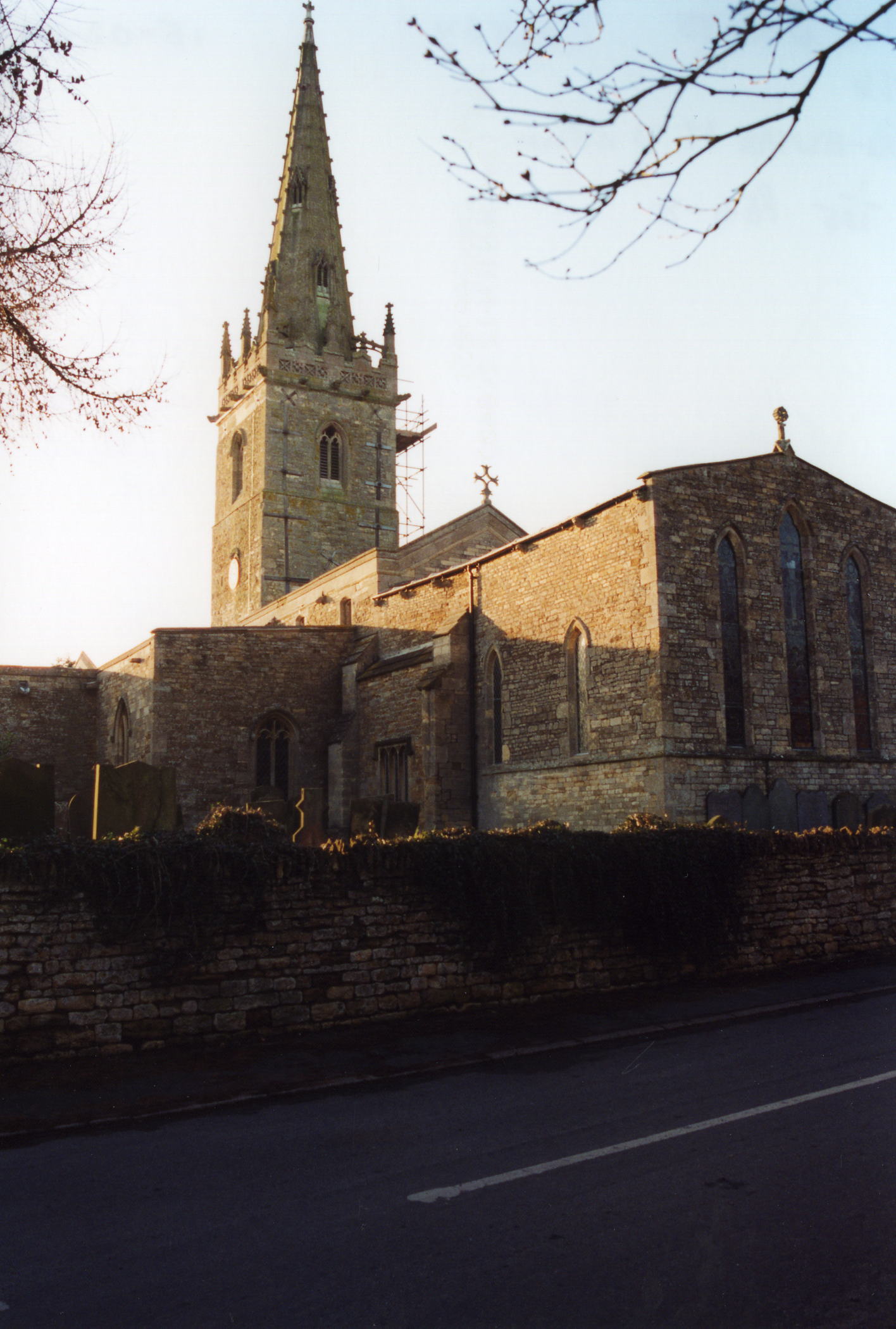
- The Anglican parish church is dedicated to All Saints.
- The church has a tower base that dates from Saxon times. The top of the tower was built in the early 15th century.
- Here is a photo of All Saints' Church, taken by Ron Cole (who retains the copyright):
- There is a publication: "The Registers of Coleby (Lincoln County) 1561-1812," transcribed by: Mrs. Tempest, produced by: Quintin Publications, 1903, Parish Register Society, 187 pgs. Price at last check was around US$20. It can be purchased either on CD-ROM or in spiral-bound form.
- We have the beginnings of a Parish Register Extract in a pop-up text file for your use. Your additions and corrections are welcomed.
- The Lincolnshire FHS has published several marriage indexes and a burial index for the Graffoe Deanery to make your search easier.
- The Wesleyan Methodists had a chapel here by 1881. For information and assistance in researching these chapels, see our non-conformist religions page.
- Check our Church Records page for county-wide resources.
- The parish was in the South West sub-district of the Lincoln Registration District.
- Check our Civil Registration page for sources and background on Civil Registration which began in July, 1837.
This village and parish lie south of Lincoln and just south of Harmston. Auborn parish is to the northwest and Boothby Graffoe parish to the south. The western boundary is the River Brant. The parish covers about 2,600 acres.
The village sits on the Cliff range, near the old Ermine Street (the Roman road from London to the Humber River). If you are planning a visit:
- Take the A15 trunk road, south out of Lincoln and turn off at the southbound A607 trunk road. Follow that south and pass Harmston village. One mile further south, just to the right, is Coleby village.
- See our touring page for more sources.
- Ask for a calculation of the distance from Coleby to another place.
- Coleby Hall was erected in 1628 on the foundation of an older "North Hall."
- According to Terry WELLS, Coleby Hall was occupied in the mid-1700s by Worcester CALLOWHILL.
- Coleby Hall was the seat of Major Arthur Cecil TEMPEST in 1900.
- See our Maps page for additional resources.
You can see maps centred on OS grid reference SK976605 (Lat/Lon: 53.132972, -0.542879), Coleby which are provided by:
- OpenStreetMap
- Google Maps
- StreetMap (Current Ordnance Survey maps)
- Bing (was Multimap)
- Old Maps Online
- National Library of Scotland (Old Ordnance Survey maps)
- Vision of Britain (Click "Historical units & statistics" for administrative areas.)
- English Jurisdictions in 1851 (Unfortunately the LDS have removed the facility to enable us to specify a starting location, you will need to search yourself on their map.)
- Magic (Geographic information) (Click + on map if it doesn't show)
- GeoHack (Links to on-line maps and location specific services.)
- All places within the same township/parish shown on an Openstreetmap map.
- Nearby townships/parishes shown on an Openstreetmap map.
- Nearby places shown on an Openstreetmap map.
- RAF Coleby Grange was opened in 1939 as a relief landing field for RAF Cranwell. The name "Coleby Grange" was used because that was what the railroads used for the parish name to avoid confusion with the other Colebys in England.
- The field was placed under the 12 Group Fighter Command in May, 1941 and squadrons were posted here for active combat sorties. The 307 Polish Squadron joined several British units here. There was only one hangar here at first and the field was always grass.
- During the war, nearby Coleby Hall served as the Officers' Mess.
- The field was closed in May, 1945.
- The field re-opened in 1959 as a Thor missile base.
- The field was closed again in 1963.
- Today the field is in private hands and used for agriculture.
- Check out the old Control Tower for a bit of nostalgia.
John EMERSON, who retains the copyright, provides these photographs of the war memorial at Coleby:
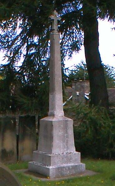
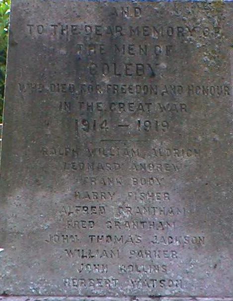
There is a photograph of the memorial and a list of names at the Roll of Honour site.
- This place was an ancient parish in Lincoln county and became a modern Civil Parish when those were established.
- The parish was in the High division of the ancient Graffoe Wapentake in the North Kesteven division of the county, in the parts of Kesteven.
- You can contact the Coleby Parish Council regarding civic or political issues, but they are NOT staffed or funded to help you with family history searches.
- For today's district governance, see the North Kesteven District Council.
- Bastardy cases would be heard in the Lincoln South petty session hearings on the first and third Friday of each month.
- The Common Lands were enclosed here in 1760.
- As a result of the 1834 Poor Law Amendment Act, the parish became part of the Lincoln Poor Law Union.
- A Parochial School was built here in 1854 and later enlarged.
- For more on researching school records, see our Schools Research page.