
Hide
Low Toynton
hide
Hide
hide
Hide
hide
Hide
Hide
Hide
- The parish was in the Tetford sub-district of the Horncastle Registration District.
- The North Lincolnshire Library has census copies for 1841 and 1881.
- Check our Census Resource page for county-wide resources.
- The table below gives census piece numbers, where known:
| Census Year | Piece No. |
|---|---|
| 1841 | H.O. 107 / 647 |
| 1851 | H.O. 107 / 2108 |
| 1871 | R.G. 10 / 3383 |
| 1891 | R.G. 12 / 2599 |
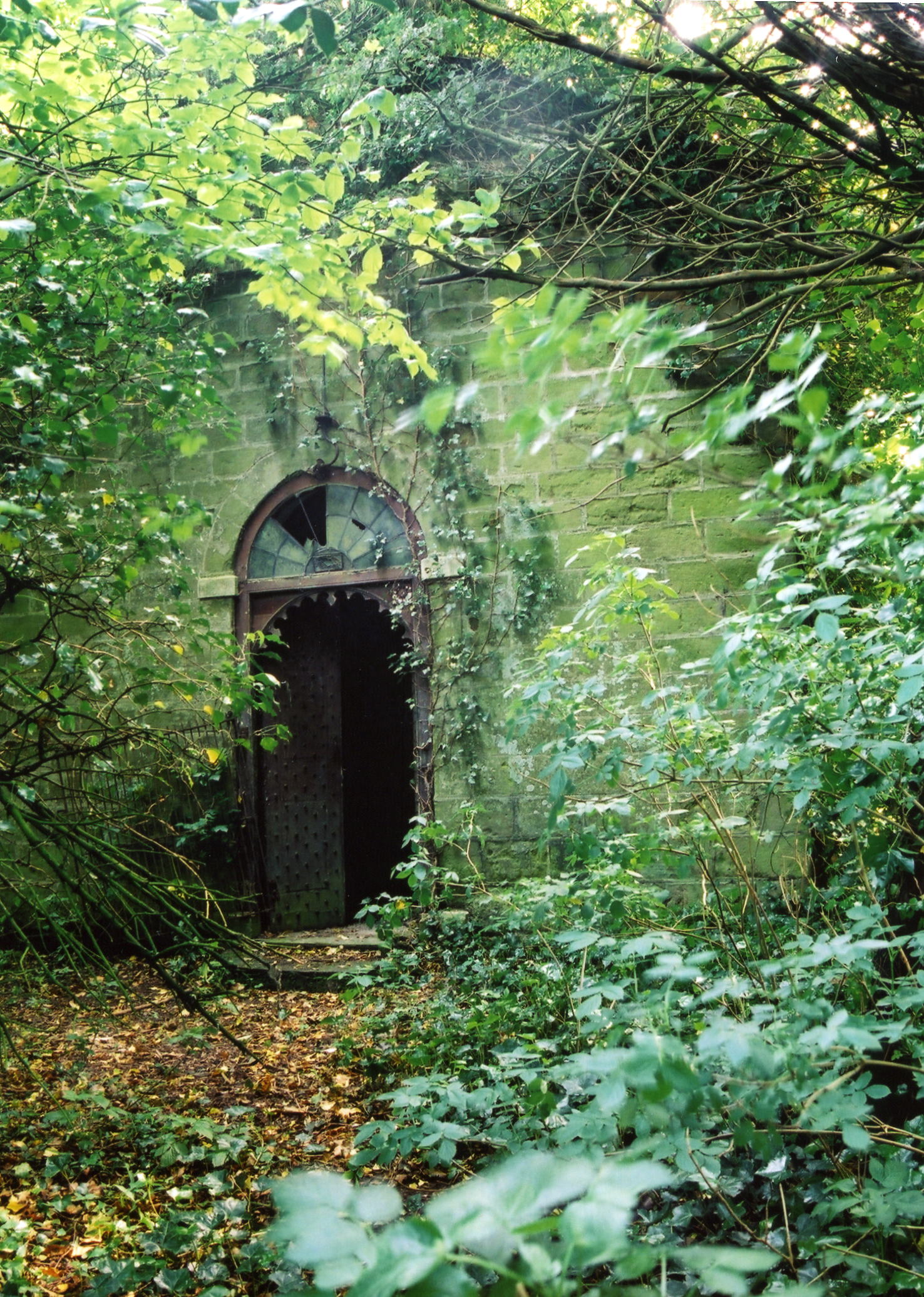
- The Anglican Parish Church is dedicated to Saint Peter.
- The church was rebuilt in 1811.
- It is a small church and only seats 60.
- The Diocese of Lincoln declared this church redundant in October, 1973. In 1977 it was sold into private use.
- The church is now an overgrown ruin, the graveyard is unkept and overgrown as well.
- David HITCHBORNE has a photograph of St. Peter's Church on Geo-graph, taken in May, 2004.
- Here is a photo of Saint Peter's church, taken by Ron COLE (who retains the copyright):
- The Anglican parish register dates from 1585.
- The Society of Genealogists has parish burials from 1813 - 1900.
- The LFHS has published several marriage and burial indexes for the Horncastle Deanery to make your search easier.
- Check our Church Records page for county-wide resources.
- The parish was in the Tetford sub-district of the Horncastle Registration District.
- Check our Civil Registration page for sources and background on Civil Registration which began in July, 1837.
Low Toynton is both a village and a parish in the Wold hills, one mile north-east of Horncastle. West Ashby and Fulletby parishes lie to the north and High Toynton parish to the south. The parish only covers about 1,000 acres.
Low Toynton village is a small place in the vale of the River Waring, now no more than a collection of cottages. If you are planning a visit:
- See our touring page for visitor services.
- Ask for a calculation of the distance from Low Toynton to another place.
- In 1842, the principal landowner was W. H. L. ROLLESTON, lord of the manor.
- In 1882, the principal landowner was E. Launcelot ROLLESTON, lord of the manor.
- See our Maps page for additional resources.
You can see maps centred on OS grid reference TF275703 (Lat/Lon: 53.214471, -0.092084), Low Toynton which are provided by:
- OpenStreetMap
- Google Maps
- StreetMap (Current Ordnance Survey maps)
- Bing (was Multimap)
- Old Maps Online
- National Library of Scotland (Old Ordnance Survey maps)
- Vision of Britain (Click "Historical units & statistics" for administrative areas.)
- English Jurisdictions in 1851 (Unfortunately the LDS have removed the facility to enable us to specify a starting location, you will need to search yourself on their map.)
- Magic (Geographic information) (Click + on map if it doesn't show)
- GeoHack (Links to on-line maps and location specific services.)
- All places within the same township/parish shown on an Openstreetmap map.
- Nearby townships/parishes shown on an Openstreetmap map.
- Nearby places shown on an Openstreetmap map.
- White's 1842 Directory lists the following surnames in the parish: BLOODWORTH, SHARP, SPRANGER and WALLER.
- White's 1872 Directory lists the following surnames in the parish: BLOODWORTH, CHAPMAN, HOLDERSHAW, STRAWSON, TURNER and WALLER.
- White's 1882 Directory lists the following surnames in the parish: BLOODWORTH, CHAPMAN, HOULDERSHAW, KEMP, PARISH, SIMONS, STRAWSON, TURNER and WALLER.
- Kelly's 1913 Directory lists the following surnames in the parish: MASON, PARISH, READ, SCHOLEY and TOMBLIN.
- This place was an ancient parish in Lincoln county and it became a modern Civil Parish when those were established.
- The parish was in the ancient Horncastle Soke in the East Lindsey district in the parts of Lindsey.
- Kelly's 1900 Directory of Lincolnshire places this parish, perhaps erroneously, in the South Lindsey division of the county.
- For today's district governance, see the East Lindsey District Council.
- Bastardy cases would be heard in the Horncastle petty session hearings.
- As a result of the 1834 Poor Law Amendment Act, the parish became part of the Horncastle Poor Law Union.
- The children of this parish attended schools in Horncastle.
- For more on researching school records, see our Schools Research page.