
Hide
Wispington
hide
Hide
hide
Hide
hide
Hide
Hide
Hide
- The parish was in the Horncastle sub-district of the Horncastle Registration District.
- The North Lincolnshire Library holds copies of the census returns for 1841 and 1881.
- Check our Census Resource page for county-wide resources.
- The table below gives census piece numbers, where known:
| Census Year | Piece No. |
|---|---|
| 1861 | R.G. 9 / 2368 |
| 1871 | R.G. 10 / 3382 |
| 1891 | R.G. 12 / 2598 |
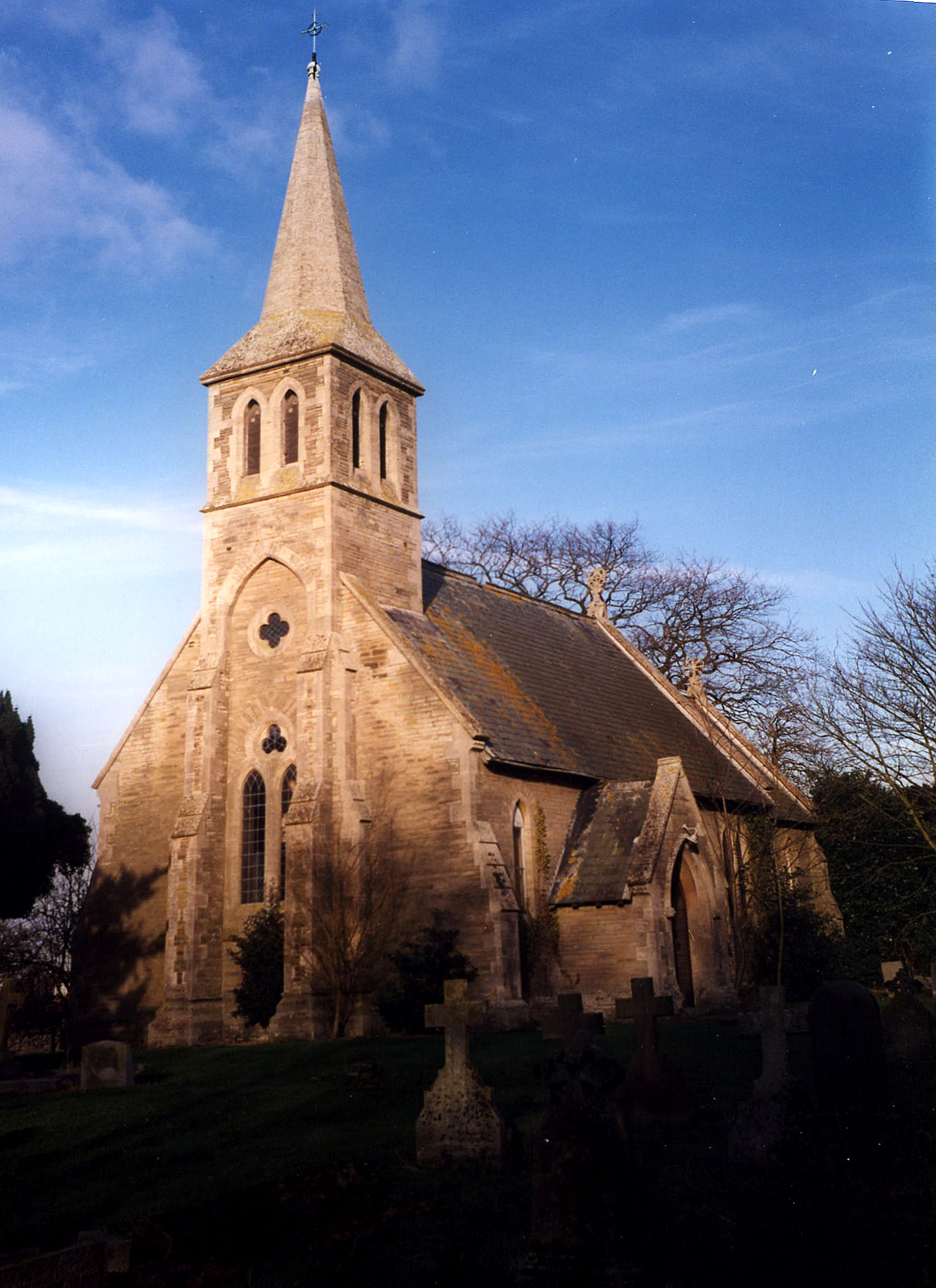
- The Anglican parish church is dedicated to Saint Margaret.
- The church is built of local stone, originally in the Norman period, it was rebuilt in stone on the same site in 1863.
- The church seats 120 persons.
- The church was declared redundant by the Diocese of Lincoln in February, 1975. It was used as a store in April, 1978.
- A photograph of Saint Margaret's Church is at the Wendy PARKINSON English Church Photographs site.
- David HITCHBORNE has a photograph of St Margaret's Church on Geo-graph, taken in August, 2004.
- Here is a photo of Saint Margaret's Church, taken by Ron COLE (who retains the copyright):
- Parish registers exist from 1662, but Bishop's transcripts go back to 1561.
- The LFHS has published several marriage indexes for the Horncastle Deanery to make your search easier.
- Check our Church Records page for county-wide resources.
- The parish was in the Horncastle sub-district of the Horncastle Registration District.
- Check our Civil Registration page for sources and background on Civil Registration which started in July, 1837.
Wispington is both a small village and a parish about 2 miles west of the River Bain and 4 miles northwest of Horncastle. The parish itself is bounded on the north by Baumber parish, to the west by Waddingworth and Bucknall, on the south by Horsington parish and on the east by Edlington parish. The parish is on a hill in the west part of The Wolds and covers almost 1,200 acres.
Wispington village is small and lies mostly on the west side of the winding road. If you are planning a visit:
- Take the B1190 secondary road, which runs between Lincoln and Horncastle. About a half mile west of Thimbleby, just west of Horncastle, turn north and follow the signs to Wispington.
- Visit our touring page for more sources.
- Ask for a calculation of the distance from Wispington to another place.
- In 1841, the principal landowner was Christopher TURNOR.
- In 1872, the principal landowner was still Christopher TURNOR.
- In 1900, the sole landowner was Edmund TURNOR, JP.
- In 1913, the sole landowner was Christopher H. TURNOR, JP, of Grantham.
- Maps WorldWide may be able to provide you with a Landranger map of Wispington. Ask for "Landranger Map 0122: Skegness & Horncastle".
- See our Maps page for additional resources.
You can see maps centred on OS grid reference TF205717 (Lat/Lon: 53.228681, -0.196326), Wispington which are provided by:
- OpenStreetMap
- Google Maps
- StreetMap (Current Ordnance Survey maps)
- Bing (was Multimap)
- Old Maps Online
- National Library of Scotland (Old Ordnance Survey maps)
- Vision of Britain (Click "Historical units & statistics" for administrative areas.)
- English Jurisdictions in 1851 (Unfortunately the LDS have removed the facility to enable us to specify a starting location, you will need to search yourself on their map.)
- Magic (Geographic information) (Click + on map if it doesn't show)
- GeoHack (Links to on-line maps and location specific services.)
- All places within the same township/parish shown on an Openstreetmap map.
- Nearby townships/parishes shown on an Openstreetmap map.
- Nearby places shown on an Openstreetmap map.
- An RCAF Hampden bomber out of Waddington crashed in the parish on the night of 19 April 1942 during a training exercise. All 4 crewmen were killed.
- The village is first recorded as Wispinctune in the 1086 Domesday Book, most likely from the Old English wisp+ing+tun or "farmstead where brushwood grows," or alternatively "farmstead belonging to a man named Wispa".
A. D. Mills, "A Dictionary of English Place-Names," Oxford University Press, 1991.
- White's 1842 Directory lists the following farmers in the parish: Thomas CAVE, John DEAR, Andrew EVISON, Robert FOX, and Charles NUNDY. The vicar was Rev. Charles P. TERROT.
- White's 1872 Directory lists the following individuals in the parish: Mark CADE, Willey CHEFFINS, Frederick DEAR, Andrew EVISON, Joseph FOX, and John NUNDY. The vicar was Rev. Charles P. TERROT.
- Kelly's 1900 Directory lists the following individuals in the parish: Andrew EVISON, James FOX, John GAUNT, Thomas GAUNT, and Stephen PARISH. The vicar was Rev. James A. PENNY.
- Kelly's 1913 Directory lists the following individuals in the parish: John DONNOR, Walter Andrew EVISON, and James GAUNT. The vicar was Rev. James Alpass PENNY, MA.
- This place was an ancient parish in Lincolnshire and became a modern Civil Parish when those were established.
- The parish was in the ancient Gartree Soke in the East Lindsey district in the parts of Lindsey.
- The citizens of this parish have elected to forgo a formal Parish Council in favour of periodic Parish Meetings where they can discuss civic and political issues.
- For today's district governance, see the East Lindsey District Council.
- Bastardy cases would be heard at the Horncastle petty session hearings.
- As a result of the 1834 Poor Law Amendment Act, the parish became part of the Horncastle Poor Law Union.
- The children of this parish attended the schools at Edlington, Minting and Horsington.
- For more on researching school records, see our Schools Research page.