
Hide
St Alban Wood-street
hide
Hide
hide
Hide
Hide
Hide
"ST. ALBAN'S CHURCH, Wood-street, Cheapside, is situated about the middle of the east side. It is an indifferent attempt at the pointed style of architecture by Sir Christopher Wren, who, it is dear by this and other of his churches in the ancient English style of Gothic architecture, had but little knowledge and feeling for this appropriate and elegant style of ecclesiastical architecture. It is dedicated to St. Alban, the Anglo-protomartyr who suffered under the persecution of Diocletian, and gave his name to the ancient town and abbey of St. Alban, in Hertfordshire. The first church on this site was erected in the year 930, and dedicated to the same saint. After various repairs, the ancient church was taken down, in 1634, and another erected, that was destroyed by the great fire of London in 1666, when the present edifice was erected after the same plan as the former. The living is a rectory, in the patronage of Eton college, and the dean and chapter of St. Paul's, alternately; and the parish of St. Olave, Silver-street, was united to it after the fire. Its present rector is the Rev. Edward J. Beckwith, one of the minor canons of St. Paul's, who was instituted in 1600." [James Elmes. A Topographical Dictionary of London and its Environs (1831) - transcribed by Brian Randell]
Hide
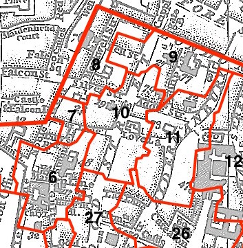
This parish - no. 10 in the above map - is located in Cripplegate Ward.
The church was destroyed in 1666, rebuilt by Wren 1682-7, Church destroyed 1940.
The parish was later united with St Vedast Foster Lane 1954.
Hide
London Metropolitan Archive holdings for St Alban Wood-street.
Online Parish Register Images and Indexes for St Alban Wood-street parish are provided by, or at various subscription sites via, the LDS FamilySearch wiki.
Non-Church of England denominations identified in St Alban Wood Street with St Olave Silver Street include: Independent/Congregational and Presbyterian [LDS FamilySearch Wiki].
Wikipedia page on St Alban Wood-street.
- Ask for a calculation of the distance from St Alban Wood-street to another place.
Summary history of St Alban Wood-street parish, from the Worshipful Company of Parish Clerks.
Public Houses, Inns & Taverns of the parish of St Alban Wood-street - provides "information from census records, trade directories, etc."
You can see maps centred on OS grid reference TQ324815 (Lat/Lon: 51.516715, -0.093937), St Alban Wood-street which are provided by:
- OpenStreetMap
- Google Maps
- StreetMap (Current Ordnance Survey maps)
- Bing (was Multimap)
- Old Maps Online
- National Library of Scotland (Old Ordnance Survey maps)
- Vision of Britain (Click "Historical units & statistics" for administrative areas.)
- English Jurisdictions in 1851 (Unfortunately the LDS have removed the facility to enable us to specify a starting location, you will need to search yourself on their map.)
- Magic (Geographic information) (Click + on map if it doesn't show)
- GeoHack (Links to on-line maps and location specific services.)
- All places within the same township/parish shown on an Openstreetmap map.
- Nearby townships/parishes shown on an Openstreetmap map.
- Nearby places shown on an Openstreetmap map.
Surnames from the 1881 census in the St Alban Wood Street district.
Clerical career summaries for the parish of (i) St Alban Wood-street and (ii) St Alban Wood Street With St Olave Silver Street, from the Clergy of the Church of England Database website.
Sources for listings of taxpayer names for St Alban Wood-street parish, listed on the LDS FamilySearch wiki.