
Hide
St Michael Bassishaw
hide
Hide
hide
Hide
Hide
Hide
"ST. MICHAEL BASSISHAW, the church of, stands on the western side of Basing- hall-street, and derives its name from its dedication to St. Michael the Archangel, and its addition from Basing's haw or hall. The ancient church was originally founded about the year 1140, and was then in the patronage of the Prior and Canons of St. Bartholomew, in Smithfield. . . The old church, which was a beautiful specimen of the ecclesiastical architecture of our ancestors, was entirely destroyed by the fire of London, and the present building was erected in its stead, from the designs of Sir Christopher Wren. It is a plain useful structure, of brick and stone, of no very striking character. The spire has an air of originality, and is skilfully contrived. This church is a rectory, in the city, diocese and archdeaconry of London, and in the patronage of the Dean and Chapter of St. Paul's. The present rector is the Rev. Christopher Packe, a Minor Canon of St. Paul's, who was instituted in 1821." [James Elmes. A Topographical Dictionary of London and its Environs (1831) - transcribed by Brian Randell]
Hide
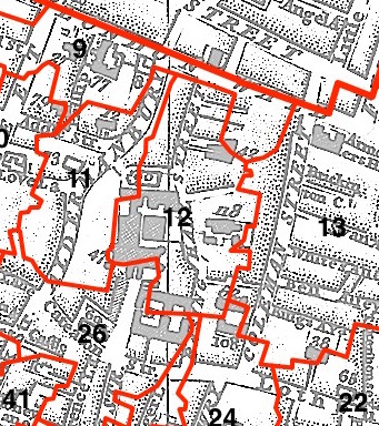
This parish - no. 12 in the above map - is located in Bassishaw Ward.
The church was destroyed in 1666, rebuilt by Wren, sold 1899, demolished 1900.
The parish was later united with St Lawrence Jewry 1897.
Hide
London Metropolitan Archive holdings for St Michael Bassishaw.
Online Parish Register Images and Indexes for St Michael Bassishaw parish are provided by, or at various subscription sites via, the LDS FamilySearch wiki.
No non-Church of England denominations have been identified for St Michael Bassishaw [LDS FamilySearch Wiki].
Wikipedia page on St Michael Bassishaw.
- Ask for a calculation of the distance from St Michael Bassishaw to another place.
Summary history of St Michael Bassishaw parish, from the Worshipful Company of Parish Clerks.
Public Houses, Inns & Taverns of the parish of St Michael Bassishaw - provides "information from census records, trade directories, etc."
You can see maps centred on OS grid reference TQ325814 (Lat/Lon: 51.516414, -0.091248), St Michael Bassishaw which are provided by:
- OpenStreetMap
- Google Maps
- StreetMap (Current Ordnance Survey maps)
- Bing (was Multimap)
- Old Maps Online
- National Library of Scotland (Old Ordnance Survey maps)
- Vision of Britain (Click "Historical units & statistics" for administrative areas.)
- English Jurisdictions in 1851 (Unfortunately the LDS have removed the facility to enable us to specify a starting location, you will need to search yourself on their map.)
- Magic (Geographic information) (Click + on map if it doesn't show)
- GeoHack (Links to on-line maps and location specific services.)
- All places within the same township/parish shown on an Openstreetmap map.
- Nearby townships/parishes shown on an Openstreetmap map.
- Nearby places shown on an Openstreetmap map.
Surnames from the 1881 census in the St Michael Bassishaw district.
Clerical career summaries for the parish of St Michael Bassishaw, from the Clergy of the Church of England Database website.
Sources for listings of taxpayer names for St Michael Bassishaw parish, listed on the LDS FamilySearch wiki.