
Hide
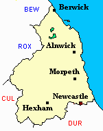
Wooler
hide
Hide
hide
Hide
Hide
Hide
"WOOLER is a small parish, comprising an area of 4,852 acres. The Earl of Tankerville is the proprietor of Wooler, and lord of the manor, and the Messrs. Clarke, of Newcastle, are the owners of Fenton. The population of the parish in 1801, was l,679; in 1811, 1,704; in 1821, 1,830; in 1831, 1,926; in 1841, 1,874; and in 1851, 1,911 souls. THE TOWN of Wooler occupies a healthy position, on the eastern declivity of the Cheviots, forty-six miles N.N.W. of Newcastle-upon-Tyne, and consists of several streets, diverging from a central area used as a market place. Wooler was one of the baronies into which this country was divided at the period of the Norman Conquest." [From History, Topography, and Directory of Northumberland, Whellan, 1855].
Hide
- History of Northumberland volume 11 (eleven) Kenneth H Vickers 1922 includes Wooler
- Official guide to wooler Vickery Kyle & Co 1921
- Views of Wooler and Glendale 1850-1950 Derek Fairangton & Roger Miket
- Wooler at War 1939 - 1945
- Wooler and Glendale a brief history volume " Wooler
- Northumberland County Record office holds copies of Census Returns 1841 - 1891 and provides a useful User Guide
- The 1851 Census Index (microfiche CN35) Glendale (Part 2) Wooler (PRO piece HO107/2422 folios 305-557) (Type B) (Book) published by theNorthumberland and Durham Family History Society may be of value to researchers interested in this parish.
- 1891 Census Wooler (Doddington, Nesbit, Fenton, Ewart, Earle, Humbleton, Middleton Hall, North and South Middleton, Ilderton, Roseden, Roddam, Selbys Forest, Akeld, Woller, Chatton, Chillingham, Hepburn, Newton, East and West Lilburn, Old and New Bewick, Brandon, Wooperton, Branton, Fawdon and Clinch, Reavley, Linhope, Greenside Hill and Hartside) (PRO piece RG12/4271) (Type B) (Book) (Volume 81) published by the Northumberland and Durham Family History Society may be of value to researchers interested in this parish.
- 1891 Census Wooler (Screnwood, Alnham, Prendwick, Unthank, Netherton, North and South Side, Great and Little Ryle, Callaley and Yetlington, Lorbottle, Whittingham, Snitter, High and Low Trewitt, Cartington, Thropton, Warton, Flotterton Mount Healey, Rothbury, Whitton, Newtown, Tosson, Bickerton, Caistron, Fallowlees, Hollinghill, Hesleyhurst Row, Brinkburn High and Low Ward, Longframlington, Todburn, Wingates, Ritton Colt Park, Ritton White House, Ewesley, Healey and Combe Hill, Nunneykirk, Coatyards, Greenleighton, Harwood Fairnley, Hartington, Hartington Hall and Rothley) (PRO piece RG12/4272) (Type B) (Book) (Volume 82) published by Northumberland and Durham Family History Society the may be of value to researchers interested in this parish.
- 1851 census index vol 25 Glendale pt 2 available to view at Local Studies Centre Newcastle City Library [shelf ref L321]
- https://www.ndfhs.org.uk/
| St Mary, Wooler, Church of England |
- Wooler - Church Records - links and information.
- This area is within Northumberland North First Registration District.
- Certificates of birth, death and marriage can be ordered locally from Northumberland County Council.
- Photographs of Wooler from Les Bell's Northumberland Cam website.
- The Northumberland Communities website includes pages relating to Wooler. They provide "a range of learning resource material that reflects Northumberland's heritage, providing a base for studying the County's history. The website provides a starting point for understanding the development of communities in Northumberland. It also seeks to illustrate the range of sources for family and local history research that are available via Northumberland Archives Service." https://www.visitwooler.org/
- The section of The National Gazetteer (1868) relating to this parish - transcribed by Colin Hinson.
- Ask for a calculation of the distance from Wooler to another place.
- The history of Wooler Parish is included in:- Northumberland County History Committee, History of Northumberland, Volume 11. Newcastle, A. Reid, 1922.
You can see maps centred on OS grid reference NT976312 (Lat/Lon: 55.574395, -2.040068), Wooler which are provided by:
- OpenStreetMap
- Google Maps
- StreetMap (Current Ordnance Survey maps)
- Bing (was Multimap)
- Old Maps Online
- National Library of Scotland (Old Ordnance Survey maps)
- Vision of Britain (Click "Historical units & statistics" for administrative areas.)
- English Jurisdictions in 1851 (Unfortunately the LDS have removed the facility to enable us to specify a starting location, you will need to search yourself on their map.)
- Magic (Geographic information) (Click + on map if it doesn't show)
- GeoHack (Links to on-line maps and location specific services.)
- All places within the same township/parish shown on an Openstreetmap map.
- Nearby townships/parishes shown on an Openstreetmap map.
- Nearby places shown on an Openstreetmap map.