
Hide
Upton
hide
Hide
hide
Hide
hide
Hide
Hide
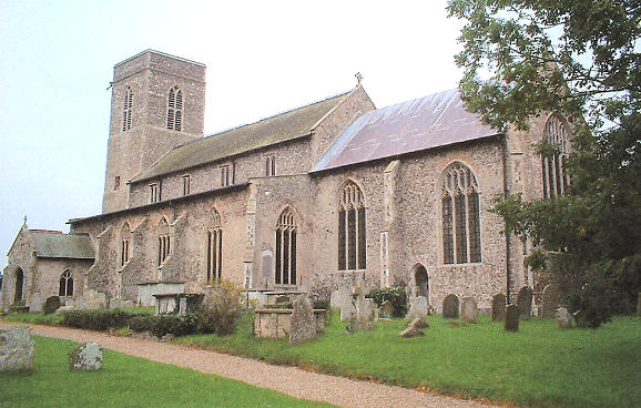
"UPTON, a straggling village, 9 miles W.N.W. of Yarmouth, has in its parish 519 souls, and upwards of 1600A. of land, exclusive of Fishley, which is united with it for the support of the poor. Wm. Waters, Esq., owns most of the soil, and is lord of the manor. The Church (St. Margaret,) had a square tower, of which part of the ruins still remain. The vicarage, valued in the King's Book at £5, is consolidated with that of Ranworth, in the incumbency of the Rev. J.W. Greaves, and patronage of the Bishop of Ely, who is also appropriator of the great tithes, which are leased to W. Waters, Esq. The tithes of Upton were commuted in 1839, the vicarial for £163, and the rectorial for £283. 15s. 6d. per annum." [William White, History, Gazetteer, and Directory of Norfolk (1845) - Transcription copyright © Pat Newby]
Hide
Upton forms a united civil parish with Fishley.
They are together known as Upton with Fishley and as Upton cum Fishley.
See also Fishley.
Hide
- Norfolk Family History Society
- Monumental Inscriptions of Upton, Norfolk.
[Norwich, Norfolk Family History Society, date unknown]
See also Norfolk Parish Links: Cemeteries
- 1891: Surname List (this is a link to an archived copy)
See also Norfolk Parish Links: Censuses
| Chapel, Upton, Primitive Methodist |
- In 1883 the parish was in the Deanery of Blofield, in the archdeaconry of Norwich.
It could have been in a different deanery or archdeaconry both before and after this date. - The parish church is dedicated to St Margaret of Antioch.
- Church of St Margaret of Antioch
- Description, pictures, minister, services, parish magazine, etc.
- Church of St Margaret of Antioch
- Description and pictures.
- Church of St Margaret of Antioch
- Services, etc.
- Church of St Margaret of Antioch
- Picture of the church.
- Marriages 1558-1812
- See Phillimore's Marriage Registers, Volume 1.
- Marriages
- These are included in Boyd's Marriage Index.
See also Norfolk Parish Links: Church Records
For the civil registration of births, marriages and deaths between 1837 and 1930 (and for the censuses from 1851 to 1901), Upton was in Blofield Registration District.
- Upton with Fishley Parish Council
- Minutes, meetings, etc.
- Upton History Group (this is a link to an archived copy)
- Description, history, pictures, etc. Some current info on above Parish Council site.
- Upton Tower Mill
- Description, history and map.
- Upton Black Drainage Mill
- Description, history and pictures.
- 1845: White's History, Gazetteer, and Directory of Norfolk
- 1850: Hunt's Directory of East Norfolk with Part of Suffolk
- 1854: White's History, Gazetteer, and Directory of Norfolk (this is a link to an archived copy)
- 1883: White's History, Gazetteer, and Directory of Norfolk
- 1883: Kelly's Directory for Cambridgeshire, Norfolk and Suffolk (this is a link to an archived copy)
See also Norfolk Parish Links: Directories
- Ask for a calculation of the distance from Upton to another place.
Upton is in Walsham Hundred.
- Parish outline and location.
- See Parish Map for Walsham Hundred
- Description of Walsham Hundred
- 1845: White's History, Gazetteer, and Directory of Norfolk
- Hill, Percival Oakley
- A history of Upton, Norfolk, with an introduction and "History of the Manor of Upton" by Walter Rye.
[Norwich, Agas H. Goose, 1891]
- Great Britain: Statute
- Upton and Fishley Inclosure and Drainage Act, 1799.
An act for dividing, allotting, and inclosing, the arable lands, intermixed pastures, open fields, half year lands, commons, and waste grounds, within the parish of Upton, in the county of Norfolk, and such parts of the open fields, called Upton Field and Fishley Crofts, as lie in the parish of Fishley, in the said county, and for draining the same, 21st March 1799.
[London, George Eyre and Andrew Strahan, 1799]
You can see maps centred on OS grid reference TG397126 (Lat/Lon: 52.658164, 1.542719), Upton which are provided by:
- OpenStreetMap
- Google Maps
- StreetMap (Current Ordnance Survey maps)
- Bing (was Multimap)
- Old Maps Online
- National Library of Scotland (Old Ordnance Survey maps)
- Vision of Britain (Click "Historical units & statistics" for administrative areas.)
- English Jurisdictions in 1851 (Unfortunately the LDS have removed the facility to enable us to specify a starting location, you will need to search yourself on their map.)
- Magic (Geographic information) (Click + on map if it doesn't show)
- GeoHack (Links to on-line maps and location specific services.)
- All places within the same township/parish shown on an Openstreetmap map.
- Nearby townships/parishes shown on an Openstreetmap map.
- Nearby places shown on an Openstreetmap map.
- Roll of Honour
- World Wars 1 and 2.
- After 1834 Upton became part of the Blofield Union, and the workhouse was at Lingwood.
These figures are from the population tables which were produced after the 10-yearly national censuses. The "Families" heading includes families and single occupiers.
|
|
There may be more people living in detached parts of the parish (if there were any) and, if so, the number may or may not be included in the figures above. It is quite difficult to be sure from the population tables.
- 1851 and 1861 Censuses
- "Parts of the following Parishes in the South Walsham Subdistrict, are situate in the Marshes at distances varying from two to seven miles from the respective villages: South Walsham St. Lawrence, Upton, Acle, Halvergate, Tunstall, Wickhampton, Freethorpe, and Reedham."
- 1901 Census
- "Including Cargate Green, and Upton Green."