
Hide
Worstead
hide
Hide
hide
Hide
hide
Hide
Hide
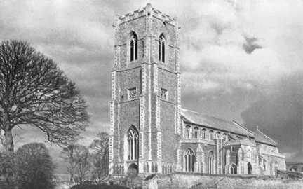
"WORSTEAD (anciently called WORSTEDE) is a parish and town, pleasantly situated on gradually rising ground near a stream, having a station on the North Walsham branch of the Great Eastern railway, 8 miles north-east from Aylsham and 3 south-by-east from North Walsham, in the Northern division of the county, Tunstead hundred, Smallburgh union, North Walsham county court distract, rural deanery of Waxham, archdeaconry of Norfolk and diocese of Norwich. The church of St. Mary is Gothic, consisting of chancel, nave, aisles and porch and embattled tower with four storeys, to which four pinnacles have been added: it has a clock and 6 bells: it is constantly being repaired and beautified, towards which a small sum was left by the late Rev. Henry Wharton: . . . The register dates from the year 1558. The living is a vicarage, yearly value £331, with residence, in the gift of the Dean and Chapter of Norwich and held since 1869 by the Rev. George Harris Cooke M.A. of Wadham College, Oxford." [Kelly's Directory for Cambridgeshire, Norfolk & Suffolk (1883) - Transcription copyright © E.C. “Paddy” Apling]
Hide
| St Mary, Worstead, Church of England |
| Cemetery, Worstead, Cemetery |
- 1841
- 1861
- 1871
- 1891: Surname List (this is a link to an archived copy)
See also Norfolk Parish Links: Censuses
- In 1883 the parish was in the Deanery of Waxham, in the archdeaconry of Norfolk.
It could have been in a different deanery or archdeaconry both before and after this date. - The parish church is dedicated to St Mary.
- Church of St Mary
- Description and pictures.
- Church of St Mary
- Picture of the church.
- Long, Anthony
- Worstead Church (St Mary), Norfolk.
[Worstead, The Church, 1970s]
- Marriages
- These are included in Boyd's Marriage Index.
They are not included in Phillimore's Marriage Registers. - Parish Registers
- Baptisms, Marriages and Burials.
See also Norfolk Parish Links: Church Records
For the civil registration of births, marriages and deaths between 1837 and 1869 (and for the censuses in 1851 and 1861), Worstead was in Tunstead and Happing Registration District.
This district was renamed on 1st January 1870 and, from then until 1930, Worstead was in Smallburgh Registration District for civil registration and for the censuses of 1871 to 1901.
- Worstead Parish Council
- Description, history, events, parish council, etc.
- Briggate Mill at Worstead
- Description, history and pictures.
- Worstead Railway Station
- Pictures of the station.
- Rendall, Ian (editor)
- Worstead Woven, a Village Compendium.
[Worstead, Worstead Festival, 2000]
- 1883: Kelly's Directory for Cambridgeshire, Norfolk and Suffolk (this is a link to an archived copy)
See also Norfolk Parish Links: Directories
- Ask for a calculation of the distance from Worstead to another place.
Worstead is in Tunstead Hundred.
- Parish outline and location.
- See Parish Map for Tunstead Hundred
- Description of Tunstead Hundred
- 1845: White's History, Gazetteer, and Directory of Norfolk
- Great Britain: Statute
- Worstead Enclosure Act, 1821.
An act for dividing and allotting lands in the parish of Worstead, in the county of Norfolk.
[George Eyre and Andrew Strahan, 1821]
You can see maps centred on OS grid reference TG303261 (Lat/Lon: 52.783246, 1.413116), Worstead which are provided by:
- OpenStreetMap
- Google Maps
- StreetMap (Current Ordnance Survey maps)
- Bing (was Multimap)
- Old Maps Online
- National Library of Scotland (Old Ordnance Survey maps)
- Vision of Britain (Click "Historical units & statistics" for administrative areas.)
- English Jurisdictions in 1851 (Unfortunately the LDS have removed the facility to enable us to specify a starting location, you will need to search yourself on their map.)
- Magic (Geographic information) (Click + on map if it doesn't show)
- GeoHack (Links to on-line maps and location specific services.)
- All places within the same township/parish shown on an Openstreetmap map.
- Nearby townships/parishes shown on an Openstreetmap map.
- Nearby places shown on an Openstreetmap map.
- Roll of Honour
- World Wars 1 and 2.
- Allison, Keith John
- The Wool Supply and the Worsted Cloth Industry in Norfolk in the sixteenth and seventeenth centuries.
[University of Leeds Dissertation, 1955] - Lipson, Ephraim
- The History of the Woollen and Worsted Industries.
[The Histories of English Industries, London, A. and C. Black, 1921]
- In 1785 Worstead became part of the Tunstead and Happing Incorporation, and the workhouse was at Smallburgh.
- In 1869 the incorporation became the Smallburgh Union.