
Hide
Cotgrave
hide
Hide
hide
Hide
hide
Hide
Hide
"Cotgrave, or as it was anciently called Codegrave, is a large village and parish, pleasantly situated on the north side of the Wolds, 6 miles south-east of Nottingham. It contains 817 inhabitants, and 3,520 acres of land at a rental of £5,341. Earl Manvers is sole proprietor, and lord of the manor, except 555 acres, which were allotted to the rector in lieu of tithes, at the enclosure about 60 years ago, and a small portion held by small freeholders. The high grounds on each side of the village contain an abundance of blue marl, intermixed with layers of red clay. Cotgrave Place is a handsome and pleasantly situated mansion, the property of Earl Manvers, and seat of Colonel Chas. John Hill."
[WHITE's "Directory of Nottinghamshire," 1853]
Hide
The Cotgrave Rural Library was established in 1850 with 1,600 volumes.
- Cotgrave Library
- Cotgrave Shopping Centre
- Cotgrave, Notts, NG12 3JQ
- Tele: 01115 989 2578
Alan MURRAY-RUST has a photograph of the Cotgrave Public Library on Geo-graph, taken in October, 2011.
The Library at Nottingham will also prove useful in your research.
Alan MURRAY-RUST has a photograph of the Lych gate, Cotgrave Cemetery on Geo-graph, taken in April, 2014.
Alan MURRAY-RUST also has a photograph of a Chest Tomb of Thomas Morris (d.1809) and his wife Elizabeth (d.1823) on c==geo-graph, taken in January, 2022.
- The parish was in the Ratcliffe upon Trent sub-district of the Bingham Registration District until November, 1883.
- The parish was then assigned to the Bingham sub-district of the Bingham Registration District.
- The table below gives census piece numbers, where known:
| Census Year | Piece No. |
|---|---|
| 1861 | R.G. 9 / 2485 |
| 1871 | R.G. 10 / 3548 |
| 1881 | R.G. 11 / 3382 |
| 1891 | R.G. 12 / 2718 |
- The Anglican parish church is dedicated to All Saints.
- The church was built in the 12th century.
- The church was restored in 1877-78.
- The church belfry and spire were restored in 1906.
- The church was damaged by fire in 1996, but has since been restored.
- The church seats 350.
- Alan MURRAY-RUST has a photograph of the Churchyard gate on Geo-graph, taken in October, 2011.
- David KELLY has a photograph of All Saints Church on Geo-graph, taken in November, 2012.
- Chris MORGAN has a photograph of All Saints Church tower on Geo-graph, taken in February, 2017.
- The Anglican parish register dates from 1559 for all entries and is in good condition.
- The Wesleyan Methodists built a chapel here in 1802.
- Geoff PICK has a photograph of the Methodist Church on Geo-graph, taken in February, 2010.
- Civil Registration began in July, 1837.
- The parish was in the Ratcliffe upon Trent sub-district of the Bingham Registration District until November, 1883.
- The parish was then assigned to the Bingham sub-district of the Bingham Registration District.
This parish and village lie 7 miles south-east of Nottingham and 3.5 miles south of Radcliffe. Stragglethorpe is a hamlet in this parish.
If you are planning a visit:
- By automobile, Cotgrave is just west of the A46 between Leicester and Newark.
- Alan MURRAY-RUST has a photograph of the Village Sign on Geo-graph, taken in April, 2014.
- We have an extract from White's 1853 Directory relating to this parish.
- Ask for a calculation of the distance from Cotgrave to another place.
- Plague came to Cotgrave in 1637.
- Alan MURRAY-RUST has a photograph of the 16th Cotgrave Cross on Geo-graph, taken in April, 2014. This is likely an old "preaching cross" used for those who had their own interpretation of the Bible to preach to followers.
- David LALLY has a photograph of the Rose and Crown Inn on Geo-graph, taken in January, 2021.
- A popular spot for local news is the Manvers' Arms in Cotgrave. Also listed as "Earl Manvers' Arms".
- Chris MORGAN has a photograph of the Manvers' Arms on Geo-graph, taken in February, 2017:
- These are the names associated with the Manvers' Arms in various directories:
| Year | Person |
|---|---|
| 1869 | Samuel TIMM |
| 1881 | John Archer TIMM |
| 1912 | George HICKLING |
- See our Maps page for additional resources.
You can see maps centred on OS grid reference SK644354 (Lat/Lon: 52.912176, -1.043791), Cotgrave which are provided by:
- OpenStreetMap
- Google Maps
- StreetMap (Current Ordnance Survey maps)
- Bing (was Multimap)
- Old Maps Online
- National Library of Scotland (Old Ordnance Survey maps)
- Vision of Britain (Click "Historical units & statistics" for administrative areas.)
- English Jurisdictions in 1851 (Unfortunately the LDS have removed the facility to enable us to specify a starting location, you will need to search yourself on their map.)
- Magic (Geographic information) (Click + on map if it doesn't show)
- GeoHack (Links to on-line maps and location specific services.)
- All places within the same township/parish shown on an Openstreetmap map.
- Nearby townships/parishes shown on an Openstreetmap map.
- Nearby places shown on an Openstreetmap map.
- The East Windows in the parish church is a War Memorial to those people of the parish who died in World War I.
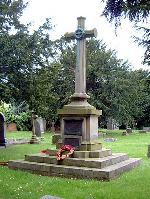
- J. THOMAS has a photograph of the War Memorial across from the parish church on Geo-graph, taken in July, 2013. The monument is on Plumtree Road. The memorial in the churchyard was unveiled in June 1920.
- There is a closer view of the War Memorial at the Southwell Church History Project website.
For a photograph of the War Memorial and the list of names on it, see the Nottingham County Council site. These are the names honoured on the Memorial:
- John Edwin Carrington, pte. 1st Bn Leicestershire Regt.
- Arthur Harrison, srgt. 11th Bn Northumberland Fusiliers
- John William Hayes, lsrgt. 2nd Bn Sherwood Foresters
- Sydney Henson, pte. 1/7th Bn West Riding Regt.
- William James Herapath, lcprl. 1/8th Bn Sherwood Foresters
- Joseph Hind, guardsman 3rd Bn Grenadier Guards
- Samuel Lacey, pte. 1st Bn Grenadier Guards
- Herbert Marshall, pte. South Nottinghamshire Hussars
- George Middleton, pte. 2nd Bn Royal Welsh Fusiliers
- Cecil Arthur Moulds, corporal Royal Army Medical Corps
- Arthur Wallhead Simpson, rifleman 7th Bn King's Royal Rifle Corps
- Francis Charles Woolley, corporal 2nd Bn King's Royal Rifle Corps
- This place was an ancient parish in Nottingham county and it became a modern Civil Parish when those were established.
- The parish was in the Bingham Wapentake (Hundred).
- In October, 1896, this parish gained the area of Lodge of the Wolds Civil Parish when that parish was abolished.
- You may contact the local Cotgrave Town Council regarding civic or politcal issues, but they are NOT staffed to help with family history lookups.
- District governance is provided by the Rushcliffe Borough Council.
- Bastardy cases would be heard in the Bingham petty session hearings held every other Thursday.
- After the Poor Law Amendment Act of 1834, this parish became part of the Bingham Poor Law Union.
- Alan MURRAY-RUST has a photograph of the 1863 C of E Primary School on Geo-graph, taken in January, 2022.