
Hide
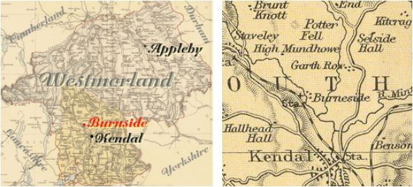
Burneside
hide
Hide
hide
Hide
Hide
Hide
"Burneshead... This name is variously written in ancient time, but most commonly Burneshead, and seems intended to signify the head of the burn or river which springs a little above in Kentmere. The chapel of Burneshead is common to Burneshead, Strickland Roger, and Strickland Ketel. To what saint it was dedicated, we have not certainly found. There is a well called the Miller's, formerly St. Oswald's well, about 30 yards north-east from the chapel, which probably leads to the name of the tutelar saint."
[Nicolson and Burn: The history and antiquities of the counties of Westmorland and Cumberland. 1777. Transcribed by A Nichols.]
Hide
Burneside is a parish in Kendal Ward before 1717 part of the very large Kendal parish.
Nearby parishes are Crook, Over Staveley, Long Sleddale, Selside and Greyr
Hide
Returns do not survive for the 'census' of 1787. Census returns are available from the usual sources for 1841-1911.
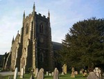
| St Oswald 1880-1. Dec style. SW towerChurch plans from ICBS archive on Church Plans Online (Lambeth Palace Library). Photograph(s) and description on VisitCumbria. Access and contact details on Church of England site More details and maps in Genuki Westmorland Church Database |
Parish Registers and Bishop's Transcripts are held by Cumbria Archives :
originals at Kendal RO and microfilm copies at Carlisle RO.
| Baptism registers | 1717-1925 |
| Marriage registers | 1717-1966 |
| Banns registers | 1823-1971 |
| Burial registers | 1826-1923 |
| Bishops transcripts | 1813-1895 |
See the CASCAT online calogue for WPR 54 for information on these and other parish records..
For searching on LDS familysearch.org see IGIbatch numbers (compiled by Jake Prescott)
or use the batch number search site (by Hugh Wallis).
The details for the parish from the Parson & White's Directory for 1829 are transcribed on Edenlinks site.
- Ask for a calculation of the distance from Burneside to another place.
Cumbria County History Trust has published a "Jubilee Digest" for the township of Burneside
You can see maps centred on OS grid reference SD494969 (Lat/Lon: 54.365165, -2.779886), Burneside which are provided by:
- OpenStreetMap
- Google Maps
- StreetMap (Current Ordnance Survey maps)
- Bing (was Multimap)
- Old Maps Online
- National Library of Scotland (Old Ordnance Survey maps)
- Vision of Britain (Click "Historical units & statistics" for administrative areas.)
- English Jurisdictions in 1851 (Unfortunately the LDS have removed the facility to enable us to specify a starting location, you will need to search yourself on their map.)
- Magic (Geographic information) (Click + on map if it doesn't show)
- GeoHack (Links to on-line maps and location specific services.)
- All places within the same township/parish shown on an Openstreetmap map.
- Nearby townships/parishes shown on an Openstreetmap map.
- Nearby places shown on an Openstreetmap map.
Wills for Burneside will be at Carlisle since about 1858 but before that will be at the Preston R.O as it was in the Diocese of Chester until that time.