Hide
Paull
hide
Hide
hide
Hide
Hide
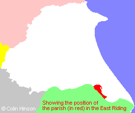
The Ancient Parish of PAULL
[Transcribed information mainly from the early 1820s]
"PAULL, (or PAUL or PAGHILL), a parish in the wapentake and liberty of Holderness; 3 miles SW. of Hedon, pleasantly situated on the East side of the Humber. This village, during the late war, was in great fame for its dockyard, where ships of the line of as high a rate as seventy-fours were built. The church, dedicated to St. Andrew and St. Mary, is a very ancient building, and is generally supposed to have been erected before the Conquest (see Churches for photograph). The living is a vicarage, in the patronage of the Archbishop of York. Here is also a Methodist chapel, with a Sunday school attached to it. Pop. 486.""BOREAS HILL, in the parish of Paull, wapentake and liberty of Holderness; 1½ miles ESE. of Paull, 2 miles S. of Hedon. Its name is very applicable to its situation, which is very much exposed to the winds; it is very near to the Humber, and the summit of Boreas Hill commands a fine prospect of her wide and expanded streams, with the numerous vessels sailing on its bosom."
"CAMERTON, in the parish of Paull, south division of Holderness; (the seat of Edward Ombler, Esq.); 3½ miles E. of Paull, 8 miles from Hedon, 7 from Patrington, 11 from Hull. --Pop. included in Ryhill."
"HIGH PAULL, in the township and parish of Paull; ½ mile SSE. of Paull, 3½ miles from Hedon, 6½ from Patrington, 10½ from Hull."
"LITTLE HUMBER, a farm house in the parish of Paull, wapentake and liberty of Holderness; 2¾ miles SE. of Paull, 3 miles S. of Hedon."
"PAULL HOLMES, a farm house in the township and parish of Paull; 1½ miles SE. of Paull, 3½ miles from Hedon."
"THORNGUMBALD, in the parish of Paull, wapentake and liberty of Holderness; 2½ miles E. of Paull, 2 miles SSE. of Hedon. Here is a small Chapel of Ease (see Churches for photograph), of which the Rev. John Bowman is Incumbent; likewise a small Independent chapel, built in 1801. This village was formerly called Thorn cum Paul, on account of its being in the parish of Paull, and is now corrupted to Thorngumbald. Pop. 259."
[Description(s) edited mainly from various 19th century sources by Colin Hinson. ©2010]
Hide
- Photographs of the over 470 gravestones and plaques at Paull Churchyard with linked surname index.
- Photographs of the 30 gravestones at Paull Cemetery with linked surname index.
- Photographs of the over 55 gravestones and plaques at Thorngumbald Churchyard with linked surname index.
- Photographs of the 380 gravestones at Thorngumbald Cemetery with linked surname index.
- Here are photographs of Churches in the parish:
- St. Andrew and St Mary's Church, Paull, view 1.
- St. Andrew and St Mary's Church, Paull, view 2.
- The spring primroses, Paull churchyard.
- The Methodist Chapel, Paull.
- St Mary's Church, Thorngumbald, view 1.
- St Mary's Church, Thorngumbald, view 2.
- The former Wesleyan Methodist Chapel, Thorngumbald.
- Transcript of the entry for Paull in the "Collections relative to Churches and Chapels".
- Transcript of the entry for Thorgumbald in the "Collections relative to Churches and Chapels".
- A transcript of Thorngumbald Congregational Church History
- The whereabouts and dates of the Registers etc. for the Parish of Paull.
- Transcript of the entry of "professions and trades" in the Baines's Directory of 1823, of the East Riding.
- Transcript of the entry of "professions and trades" in the The Post Office Directory of the, East and North Ridings, 1857
- Transcript of the entry of "professions and trades" in the Bulmers Directory of 1892. of the East Riding.
- There is further information about this parish from the Pigot's 1829 Directory, Yorkshire section.
- There is further information about this parish from the Pigot's 1834 Directory, Yorkshire section.
- There is further information about this parish from the National Gazetteer 1868, Yorkshire extracts.
- There is further information about this parish from the Lewis's Topographical Dictionary of England 1835, Yorkshire extracts.
- There is further information about this parish from the Bulmer's 1892 History and Directory of the East Riding.
- Ask for a calculation of the distance from Paull to another place.
- The Holderness Rangers have put together a history of the Lighthouses at Paull.

- For a detailed map of this parish see this parish boundaries map.
- For a more detailed map of the parishes in the riding please see the Yorkshire parish maps page.
- For a more detailed map of the county please see the Yorkshire map page.
- Here is a map showing the wapentakes for the county.
You can see maps centred on OS grid reference TA166265 (Lat/Lon: 53.721886, -0.234397), Paull which are provided by:
- OpenStreetMap
- Google Maps
- StreetMap (Current Ordnance Survey maps)
- Bing (was Multimap)
- Old Maps Online
- National Library of Scotland (Old Ordnance Survey maps)
- Vision of Britain (Click "Historical units & statistics" for administrative areas.)
- English Jurisdictions in 1851 (Unfortunately the LDS have removed the facility to enable us to specify a starting location, you will need to search yourself on their map.)
- Magic (Geographic information) (Click + on map if it doesn't show)
- GeoHack (Links to on-line maps and location specific services.)
- All places within the same township/parish shown on an Openstreetmap map.
- Nearby townships/parishes shown on an Openstreetmap map.
- Nearby places shown on an Openstreetmap map.
- A transcription of the School Timetables, around 1902-3 in Adobe pdf format.
- This parish is covered by the following Society:
- The 1834 Electoral Roll for this parish

