
Hide
Fewston
hide
Hide
hide
Hide
Hide
The Ancient Parish of FEWSTON
[Transcribed information mainly from the early 1820s]
"FEWSTON, a parish-town, in the lower-division of Claro; 7 miles N. of Otley, 11 from Knaresborough, 14½ from Skipton, 29 from York. Pop. 610. The Church is a vicarage, dedicated to St. Mary Magdalen, in the deanry of the Ainsty, value ~£6. 13s. 4d. p.r. !£113. Patron, the King."Information on the following places in this Parish is contained on a supplementary page.
|
|
|
[Description(s) edited from various 19th century sources by Colin Hinson © 2013]
Hide
- Here are two photographs of the parish church:
- St. Michael & St. Lawrence's Church, Fewston (view 1).
- Internal view looking down the nave
- St. Michael & St. Lawrence's Church, Fewston (view 2).
- The Methodist Church, Norwood Bottoms.
- Internal view looking down the nave
- St. Andrew's Church, Blubberhouses (view 1).
- St. Andrew's Church, Blubberhouses (view 2).
- St. Michael & St. Lawrence's Church, Fewston (view 1).
- Transcript of the entry for Fewston in the "Collections relative to Churches and Chapels".
- The whereabouts and dates of the Registers etc. for the Parish of Fewston.
- The whereabouts and dates of the Registers etc. for the Chapelry of Thruscross.
- Garry Stockdill's Yorksview website contains a description and photographs of Fewston.
- Transcript of the entry of "professions and trades" in the Baines's Directory and Gazetteer, Vol I, West Riding.
- There is further information about this parish from the National Gazetteer 1868, Yorkshire extracts.
- There is further information about this parish from the Lewis's Topographical Dictionary of England, Yorkshire extracts.
- Ask for a calculation of the distance from Fewston to another place.
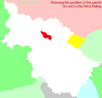
- For a detailed map of this parish see this parish boundaries map.
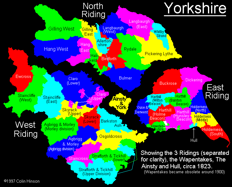
- For a more detailed map of the parishes in the riding please see the Yorkshire parish maps page.
- For a more detailed map of the county please see the Yorkshire map page.
- Here is a map showing the wapentakes for the county.
You can see maps centred on OS grid reference SE192542 (Lat/Lon: 53.983501, -1.708705), Fewston which are provided by:
- OpenStreetMap
- Google Maps
- StreetMap (Current Ordnance Survey maps)
- Bing (was Multimap)
- Old Maps Online
- National Library of Scotland (Old Ordnance Survey maps)
- Vision of Britain (Click "Historical units & statistics" for administrative areas.)
- English Jurisdictions in 1851 (Unfortunately the LDS have removed the facility to enable us to specify a starting location, you will need to search yourself on their map.)
- Magic (Geographic information) (Click + on map if it doesn't show)
- GeoHack (Links to on-line maps and location specific services.)
- All places within the same township/parish shown on an Openstreetmap map.
- Nearby townships/parishes shown on an Openstreetmap map.
- Nearby places shown on an Openstreetmap map.
- The following places are within the boundaries of this (ancient) parish, but I have no further information on them other than the Ordnance Survey Landranger Grid reference shown:
- (SE206531) Bland Hill
- (SE216536) Brown Bank
- (SE207538) Bramelane
- (SE204515) Brass Castle
- (SE205529) Cooper House
- (SE203558) Dangerous Corner
- (SE210505) Norwood Hall
- (SE207522) Paddock Hill
- (SE202524) Scow Hall
- (SE213533) Whistle House
- (SE217552) Willow House
- (SE201546) Wydra
- This parish is covered by the following Society:
- A list of those paying the 1379 Subsidy Rolls (Poll Tax) for this parish.