
Hide
Handsworth
hide
Hide
hide
Hide
Hide
The Ancient Parish of HANDSWORTH
[Transcribed information mainly from the early 1820s]
"HANDSWORTH, a parish-town, in the upper-division of Strafforth and Tickhill, liberties of St. Peter and Hallamshire; 4½ miles SE. of Sheffield, 7 from Rotherham, 12½ from Chesterfield, (Derby.) 55 from York. Pop. 2,173. The Church is a rectory, dedicated to St. Mary, in the deanry of Doncaster, value, £12. 4s. 7d. Patron, the Duke of Norfolk.Handsworth is situated upon an eminence, on the turnpike road from Sheffield to Worksop, from which are commanded extensive and beautiful views of the surrounding country. Not far from the church yard stands the village school, a respectable stone building, erected by subscription in the year 1800, for the education of a certain number of poor children, to be elected pursuant to the Will of Dr. Lockier, formerly rector of this parish, who, with the Hon. Mrs. Jane Howard, wife of the rector, gave the uses of certain monies for its endowment. For an account of this parish, see Hunter's Hallamshire."
Information on the following places in this Parish is contained on a supplementary page.
|
|
[Description(s) edited from various 19th century sources by Colin Hinson © 2013]
Hide
- Here is a photograph of The Cemetery Chapel, Handsworth.
- Here is a photograph of The Cemetery Chapel, Woodhouse.
- Here are photographs of Churches etc. in the parish:
- St. Mary's Church, Handsworth (view 1) - slight tree problem!
- St. Mary's Church, Handsworth (view 2).
- Handsworth Methodist Church, Handsworth.
- The Roman Catholic Church, Handsworth.
- Handsworth Christian Life Centre, Handsworth.
- Trinity Methodist Church, Woodhouse.
- The former United Methodist Church, Woodhouse (now the Tythe Barn Community Centre).
- Southern Light Community Church, Woodhouse.
- The Salvation Army Hall, Woodhouse.
- The former Quaker Meeting House, Woodhouse.
- The former Chapel, Woodhouse (now a Carpet Warehouse).
- The dis-used Chapel, Woodhouse.
- The Church of St. Catherine of Siena, Richmond.
- Richmond Wesleyan Reform Church, Richmond.
- Christ Church, Gleadless.
- The United Reformed Church, Gleadless (originally a Bethel Chapel).
- The Methodist Church, Gleadless (view 1).
- The Methodist Church, Gleadless (view 2).
- Hollinsend Methodist Church, Hollinsend, please contact the church via their website for access to Church Records (see below). (The Church's website is here.)
- Hollinsend Methodist Church, Hollinsend - an old photograph.
- Holy Cross Church, Gleadless Valley.
- The Methodist Church, Intake, now a Boy Scout Hut. The Scouts bought the front of the church, the place of worship is at the back of this building.
- A transcription of the Woodhouse Congregational Church History
- Transcript of the entry for Handsworth in the "Collections relative to Churches and Chapels".
- The whereabouts and dates of the Registers etc. for the Parish of Handsworth.
- Transcript of the entry of "professions and trades" in the Baines's Directory and Gazetteer, Vol I, West Riding.
- There is further information about this parish from the National Gazetteer 1868, Yorkshire extracts.
- There is further information about this parish from the Lewis's Topographical Dictionary of England, Yorkshire extracts.
- Ask for a calculation of the distance from Handsworth to another place.
- A transcription of the Woodhouse Congregational Church History
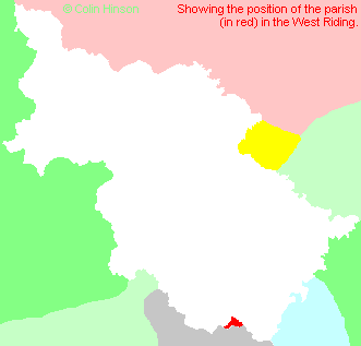
- For a detailed map of this parish see this parish boundaries map.
- For a more detailed map of the parishes in the riding please see the Yorkshire parish maps page.
- For a more detailed map of the county please see the Yorkshire map page.
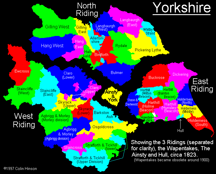
- Here is a map showing the wapentakes for the county.
You can see maps centred on OS grid reference SK410864 (Lat/Lon: 53.372876, -1.385222), Handsworth which are provided by:
- OpenStreetMap
- Google Maps
- StreetMap (Current Ordnance Survey maps)
- Bing (was Multimap)
- Old Maps Online
- National Library of Scotland (Old Ordnance Survey maps)
- Vision of Britain (Click "Historical units & statistics" for administrative areas.)
- English Jurisdictions in 1851 (Unfortunately the LDS have removed the facility to enable us to specify a starting location, you will need to search yourself on their map.)
- Magic (Geographic information) (Click + on map if it doesn't show)
- GeoHack (Links to on-line maps and location specific services.)
- All places within the same township/parish shown on an Openstreetmap map.
- Nearby townships/parishes shown on an Openstreetmap map.
- Nearby places shown on an Openstreetmap map.
- The War Memorial at Handsworth, Sheffield.
- The following places are within the boundaries of this (ancient) parish, but I have no further information on them other than the Ordnance Survey Landranger Grid reference shown:
- (SK405846) Normanton Spring
- (SK415847) Coisley Hill
- (SK390840) Hollins End
- This parish is covered by the following Society:
- A list of those paying the 1379 Subsidy Rolls (Poll Tax) for this parish.