
Hide
Scrabby Parish
hide
Hide
hide
Hide
hide
Hide
Hide
hide
Hide
"Scrabby, or Ballimackellenny, a post-town and parish, in the barony of Tulloghonoho, county of Cavan, and province of Ulster, 15 miles (S. W.by S.) from Cavan, and 70 (N. N. W.) from Dublin; containing 2668 inhabitants, of which number, 183 are in the town. This small town, which in 1881 contained 40 houses, consists chiefly of one street extending along the road from Arvagh to Granard; it has a sub-post-office to Crossdoney, and fairs are held on Feb. 10th, May 12th, Aug. 1st, and Dec. 12th. The parish comprises, accord-ing to the Ordnance survey, 6661 statute acres, of which 1182 are in Lough Gowna; the land is of indifferent quality. It is a vicarage, in the diocese of Ardagh, forming part of the union of Granard: the rectory is in dispute. The tithes amount to £157.16. 11., of which £87.18 10. is payable to the vicar, the remainder is rectorial. The church adjoins the town."
[From Lewis' Topographical Dictionary (1837)]
Hide
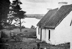
Lough Gowna, photo from This is Cavan and Monaghan, The Green Guide Series, Dublin, 1950?
The transcription for this parish from the National Gazetteer (1868), provided by Colin Hinson.
- Ask for a calculation of the distance from Scrabby Parish to another place.
You can see maps centred on OSI grid reference N3047292944 (Lat/Lon: 53.885147, -7.537346), Scrabby Parish which are provided by:
- OpenStreetMap
- Google Maps
- Bing (was Multimap)
- Copy
Scrabby Parishand paste it along with the county name into the search box at Ordnance Survey Ireland. - GeoHack (Links to on-line maps and location specific services.)
- All places within the same township/parish shown on an Openstreetmap map.
- Nearby townships/parishes shown on an Openstreetmap map.
- Nearby places shown on an Openstreetmap map.
- 1630 Muster Roll: Barony of Tullyhunco