
Hide
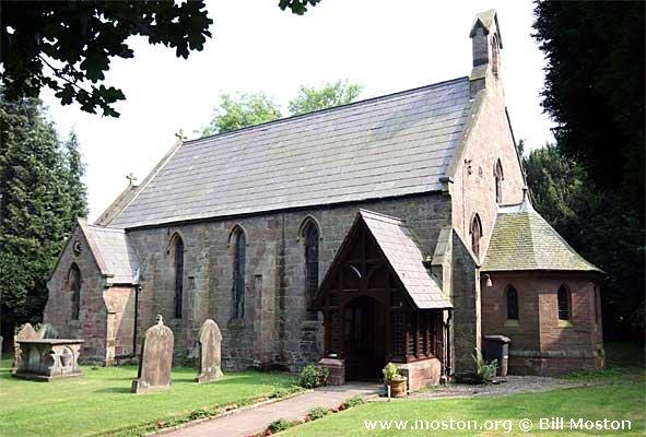
Holy Trinity, Bickerton, Church of England
hide
Hide
Hide
Holy Trinity,
Goldford Lane/Long Lane,
Bickerton
Hide
It was founded in 1839.
Long Lane/Goldford Lane
Church History
Built in 1840 as a chapel to Malpas: St. Oswald. In 1843 it became the district church for the townships of Bickerton, Broxton, Bulkeley, Duckington, Egerton and Larkton (previously served by Malpas: St. Oswald).
Church Records
C = Christenings (Baptisms) ; M = Marriages ; B = Burials ; BTs = Bishop's Transcripts
| Original Registers | C 1847-1960 ; M 1868-1987 ; B 1847-1948 — Cheshire Archives (P 227) C from 1961 ; M from 1987 — Church |
| Microfilm Copies | C 1847-1960 ; M 1868-1952 ; B 1847-1948 — Cheshire Archives |
| Copies and Indexes | M 1868-1973 — Cheshire BMD (CW:1011) |
| Bishop's Transcripts | 1847, 1855-1910 (microfilmed) — Cheshire Archives |
It is located at SJ5101353550 (Lat/Lon 53.076921, -2.732676). You can see this on maps provided by:
- OpenStreetMap
- Google Maps
- StreetMap (Current Ordnance Survey maps)
- Bing (was Multimap)
- Old Maps Online
- National Library of Scotland (Old Ordnance Survey maps)
- Vision of Britain (Click "Historical units & statistics" for administrative areas.)
- English Jurisdictions in 1851 (Unfortunately the LDS have removed the facility to enable us to specify a starting location, you will need to search yourself on their map.)
- Magic (Geographic information) (Click + on map if it doesn't show)
- GeoHack (Links to on-line maps and location specific services.)