
Hide
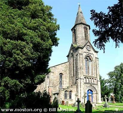
St John the Evangelist, Buglawton, Church of England
hide
Hide
Hide
St John the Evangelist,
Buxton Road,
Buglawton
Hide
It was founded in 1841.
Church History
Built in 1840 as a chapel to Astbury: St. Mary. In 1841 it became the district church for the township of Buglawton and part of the parish of Eaton (previously served by Astbury: St. Mary).
Church Records
C = Christenings (Baptisms) ; M = Marriages ; B = Burials ; BTs = Bishop's Transcripts
| Original Registers | C 1840-1957 ; M 1841-1950 ; B 1839-1939 — Cheshire Archives (P 141) C from 1957 ; M from 1950 ; B from 1939 — Church |
| Microfilm Copies | C 1840-1957 ; M 1841-1950 ; B 1839-1939 — Cheshire Archives C 1840-1895 ; M 1841-1891 ; B 1839-1939 — Manchester Archives & Local Studies ; Family History Society of Cheshire ; Congleton Library |
| Bishop's Transcripts | 1841-1893 — recorded in the BTs of Astbury: St. Mary 1893-1894 (microfilmed) — Cheshire Archives ; Family History Society of Cheshire |
| Copies and Indexes | C 1840-1849 ; B 1839-1849 (copy registers) — at Astbury: St. Mary M 1841-1994 — Cheshire BMD (CE:1017) |
It is located at SJ8699863689 (Lat/Lon 53.170156, -2.195953). You can see this on maps provided by:
- OpenStreetMap
- Google Maps
- StreetMap (Current Ordnance Survey maps)
- Bing (was Multimap)
- Old Maps Online
- National Library of Scotland (Old Ordnance Survey maps)
- Vision of Britain (Click "Historical units & statistics" for administrative areas.)
- English Jurisdictions in 1851 (Unfortunately the LDS have removed the facility to enable us to specify a starting location, you will need to search yourself on their map.)
- Magic (Geographic information) (Click + on map if it doesn't show)
- GeoHack (Links to on-line maps and location specific services.)