
Hide
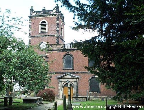
St John the Baptist, Knutsford, Church of England
hide
Hide
Hide
St John the Baptist,
Church Hill,
Knutsford
Hide
It was founded in 1744.
Church Hill.
Church History
An ancient parish church (formerly dedicated to: St. Helena), originally serving the townships of Bexton, Knutsford Nether, Ollerton, Knutsford Over and Toft.
The district was affected by the following boundary changes:
- 1840 — reduced when the township of Ollerton was transferred to Marthall: All Saints.
- 1855 — reduced when the townships of Bexton and Toft, and part of the township of Knutsford Nether, were transfered to Toft: St. John the Evangelist.
- 1860 August 30 — reduced when the township of Knutsford Over and part of the township of Knutsford Nether were transferred to Knutsford: St. Cross.
- 1968 November 22 — (details not available)
Church Records
C = Christenings (Baptisms) ; M = Marriages ; B = Burials ; BTs = Bishop's Transcripts
| Original Registers | C 1582-1969 ; M 1582-1970 ; B 1582-1972 — Cheshire Archives (P 7) C from 1969 ; M from 1970 — Church |
| Microfilm Copies | C 1582-1928 ; M 1582-1952 ; B 1582-1972 — Cheshire Archives C 1582-1928 ; M 1582-1924 ; B 1582-1942 — Family History Society of Cheshire, Knutsford Library ; Wilmslow Library |
| Bishop's Transcripts | 1581, 1608, 1610, 1617-18, 1620, 1622-25, 1627-30, 1633-34, 1640, 1662-63, 1665-68, 1670-77, 1679-85, 1687-89, 1691-96, 1698-1768, 1770-1815, 1825, 1827-67 (microfilmed) — Cheshire Archives ; Family History Society of Cheshire |
| Copies and Indexes | M 1754-1837 — North & East Cheshire Marriage Index - may be viewable at subscription sites such as ancestry or findmypast M 1620-1837(incomplete) — Bertram Merrell Marriage Index of Cheshire (1750-1836) M 1837-1993 — Cheshire BMD (CE:1049) B 1582-1752 — published by Cheshire Parish Register Project |
| Monumental Inscriptions | Published by North Cheshire Family History Society, 1975 Transcript by Family History Society of Cheshire (edited by J. Barnes) 1979 (partial) — Cheshire Archives |
It is located at SJ7524378532 (Lat/Lon 53.303149, -2.372957). You can see this on maps provided by:
- OpenStreetMap
- Google Maps
- StreetMap (Current Ordnance Survey maps)
- Bing (was Multimap)
- Old Maps Online
- National Library of Scotland (Old Ordnance Survey maps)
- Vision of Britain (Click "Historical units & statistics" for administrative areas.)
- English Jurisdictions in 1851 (Unfortunately the LDS have removed the facility to enable us to specify a starting location, you will need to search yourself on their map.)
- Magic (Geographic information) (Click + on map if it doesn't show)
- GeoHack (Links to on-line maps and location specific services.)