
Hide
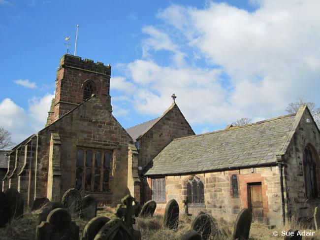
Holy Cross, Woodchurch, Church of England
hide
Hide
Hide
Holy Cross,
Pool Lane,
Woodchurch
Hide
^Click the arrow on the line above to find links to search for web sites of current churches when one is not listed here, or within the address. Some churches keep closing so if it has had to close then please let us know.
It was founded before 1200.
School Lane
Church History
An ancient parish church, originally serving the townships of Arrowe, Barnston, Landican, Noctorum, Oxton, Pensby, Prenton, Thingwall and Woodchurch, and parts ot the townships of Claughton with Grange and Irby.
The district was affected by the following boundary changes:
- 1851 — reduced when the township of Oxton, and part of the township of Claughton with Grange were transferred to Oxton: St. Saviour.
- 1870 November 29 — reduced when the township of Barnston was transferred to Barnston: Christ Church.
- 1880 February 27 — reduced when the township of Pensby was transferred to Barnston: Christ Church.
- 1902 March 7 — reduced when the township of Prenton was transferred to Prenton: St. Stephen.
- 1948 February 27 — reduced when the following area was transferred to Prenton: St. Stephen: "All that portion of the said parish of Woodchurch bounded upon the north by the said parish of Saint Saviour, Oxton, upon the east by the said parish of Saint Stephen, Prenton, upon the south by the parish of Bebington and upon the remaining side, that is to say upon the west by an imaginary line commencing at a point in the centre of the Wrexham and Bidston branch of the Bntish Railways (Eastern Region) on the boundary which divides the said parish of Bebington from the said parish of Woodchurch and extending thence north westwards along the middle of the said branch railway to its junction with the boundary which divides the said pansh of Woodchurch from the said parish of Saint Saviour, Oxton"
- 1959 February 24 — reduced when the following area was transferred to Barnston: Christ Church: "All that part of the parish of Woodchurch which is bounded on the south by the parish of Barnston, on the southeast by the parish of Bebington and on the remaining sides by an imaginary line commencing at a point on the boundary which divides the parish of Bebington from the parish of Woodchurch in the middle of Prenton Brook opposite the southeastern end of the northeastern boundary of close numbered 4733 (on the map) and extending thence northwestwards to and along the last mentioned boundary to the southeastern corner of close numbered 5155 thence first northwards then westwards along the eastern and northern boundaries of close numbered 5155 to the southeastern corner of close numbered 4568 thence northwards along the eastern boundary of close numbered 4568 and in a straight line in continuation thereof to a point in the middle of the unnamed brook or stream which rises in close numbered 8414 and flows generally southeastwards to meet Prenton Brook at the northeastern corner of close numbered 8763 and continuing thence northwestwards along the middle of the said brook or stream to the point at the northeastern corner of close numbered 8414 where it is crossed by the middle of an unnamed footpath leading westwards to Barnston Road and continuing thence westwards along the middle of the said footpath and in a straight line in continuation thereof to the middle of Barnston Road thence northwestwards along the middle of Barnston Road to a point opposite the middle of the northeastern end of Thingwall Road thence southwestwards along the middle of Thingwall Road to a point in the middle of the culvert which carries Arrowe Brook under Thingwall Road and continuing thence generally southwestwards along the middle of Arrowe Brook to the point where it is crossed by the middle of an unnamed footpath which leads through close numbered 4736 towards Antons Road and continuing thence first eastwards, then southeastwards along the middle of the last mentioned footpath to the eastern boundary of close numbered 4736 thence southwards along the last mentioned boundary to the boundary which divides the parish of Woodchurch from the parish of Barnston".
- 1959 February 24 — reduced when the following area was transferred to Thurstaston: St. Bartholomew: "All that part of the parish of Woodchurch which lies to the west of an imaginary line commencing at the point where the boundaries of the parishes of Frankby, Thurstaston, and Woodchurch all meet in Arrowe Brook Lane and extending thence southeastwards to and along the middle of Limbo Lane to its end and in a straight line in continuation thereof to a point in the middle of Thingwall Road on the imaginary line described in paragraph 1 of this
Schedule and continuing thence first southwestwards then southwards then southeastwards along the last mentioned imaginary line to the boundary which divides the parish of Woodchurch from the parish of Barnston." - 1969 February 10 — alteration to the boundary with Upton: St. Mary (details not available).
Church Records
C = Christenings (Baptisms) ; M = Marriages ; B = Burials ; BTs = Bishop's Transcripts
| Original Registers | C 1571-1945 ; M 1571-1951 ; B 1571-1913 — Cheshire Archives (P 50) C from 1945 ; M from 1952 ; B from 1914 — Church |
| Microfilm Copies | C 1571-1945 ; M 1571-1951 ; B 1571-1913 — Cheshire Archives C 1571-1945 ; M 1571-1930 ; B 1571-1913 — Family History Society of Cheshire ; Manchester Archives & Local Studies ; Birkenhead Central Library |
| Bishop's Transcripts | 1581, 1586, 1588, 1596, 1600, 1604-05, 1607, 1609-10, 1615, 1617-19,1621-24, 1626-27, 1630, 1632, 1634, 1636, 1638, 1642, 1658-60, 1666,1668-70, 1672-76, 1679-82, 1684, 1690-91, 1693, 1695-97, 1699-1739,1741-54, 1756-1826, 1829-37, 1855-56, 1858-94 (microfilmed) — Cheshire Archives |
| Copies and Indexes | CMB 1571-1871 — Cheshire Parish Register Project CM 1571-1840 ; B 1580-1840 (transcript) — Cheshire Archives ; Society of Genealogists' Library C 1571-1663 ; B 1655-1659 (transcript/index) — Cheshire Archives M 1572-1837 (incomplete) — Bertram Merrell Marriage Index of Cheshire (1750-1836) M 1837-1951 — Cheshire BMD (WR:BK21) |
| Monumental Inscriptions | Published by the Family History Society of Cheshire, 2001 |
It is located at SJ2756686852 (Lat/Lon 53.373541, -3.090196). You can see this on maps provided by:
- OpenStreetMap
- Google Maps
- StreetMap (Current Ordnance Survey maps)
- Bing (was Multimap)
- Old Maps Online
- National Library of Scotland (Old Ordnance Survey maps)
- Vision of Britain (Click "Historical units & statistics" for administrative areas.)
- English Jurisdictions in 1851 (Unfortunately the LDS have removed the facility to enable us to specify a starting location, you will need to search yourself on their map.)
- Magic (Geographic information) (Click + on map if it doesn't show)
- GeoHack (Links to on-line maps and location specific services.)