
Hide
Horwood
hide
Hide
hide
- Almanacs◬
- Archives & Libraries◬
- Bibliography◬
- Biography◬
- Business & Commerce Records◬
- Cemeteries
- Census
- Chronology◬
- Church History
- Church Records
- Churches
- Civil Registration◬
- Correctional Institutions◬
- Court Records◬
- Description & Travel
- Directories
- Emigration & Immigration◬
- Encyclopaedias & Dictionaries◬
- Folklore◬
- Gazetteers
- Genealogy
- Handwriting◬
- Heraldry◬
- Historical Geography◬
Hide
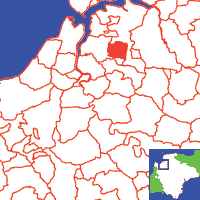
Click on map to view parish boundaries in detail.
Hide
Hide
hide
- History
- Jewish History◬
- Land & Property◬
- Language & Languages◬
- Manors◬
- Maps
- Medical Records◬
- Merchant Marine◬
- Military History
- Names, Geographical◬
- Names, Personal◬
- Newspapers◬
- Occupations◬
- Periodicals◬
- Politics & Government◬
- Poor Houses, Poor Law◬
- Population◬
- Probate Records◬
- Schools◬
- Social Life & Customs◬
- Societies◬
- Taxation◬
- Voting Registers◬
Hide
"HORWOOD, a small village and parish, 3 miles E.N.E. of Bideford, has only 118 souls, and about 750 acres of land, nearly all belonging to the Rev. John Hogg, and Earl Fortescue. The Rev. J. Dene owns the estates called Church and Pen Horwood, and is patron and incumbent of the rectory, valued in K.B. at £7. 8s. 4d., and in 1831 at £157. The tithes were commuted in 1848, for £127 per annum, and the glebe is 36 acres. The Church (St. Michael,) has a tower and three bells, and contains memorials of the Denes, Rolles, and Pollards. The Rev. John Dene, M.A. has a pleasant seat, called Horwood House, and the other principal residents are - Thomas Copp, Joshua Downing, and Wm. Jenn, farmers, and Edw. Lee, blacksmith." [From White's Devonshire Directory (1850)]
A parish in Fremington Hundred, the Archdeaconry of Barnstaple, and the Diocese of Exeter.
Hide
MIs for this parish are included in the NDA North Devon index - see under Cemeteries on the main Devon page.
[Monumental Inscriptions (church)], Gent. Mag., vol. I, (1879) pp.398-400.
Snetzler, M.F. North Devon Surname Index to the Census. Microfiche: M.F. Snetzler. [Covers 1841, 1861, 1871 and 1881 census records for this parish]
Parish Registers going back to 1653 are held in the Devon Record Office.
Transcripts of the Parish Registers going back to 1653 are held in a special collection in the Westcountry Studies Library.
The Devon FHS publishes indexes covering (as of June 2004): Marriages 1654-1837, Burials 1675-1837 - for details see their Devon Parish List.
Nothing entered into the IGI (as of Jan 1993).
Deanery of Barnstaple - Baptisms 1813-1839, Marriages 1754-1837 and Burials 1813-1837 - CD-ROM, Exeter, Devon FHS (2005). [Index of Atherington: Baptisms (1813-1839), Marriages (1754-1837), Burials (1800-1837), Barnstaple: Baptisms (1813-1839), Marriages (1754-1837), Burials (1813-1837), Bishops Tawton: Baptisms (1813-1839), Marriages (1754-1837), Burials (1813-1837), Chittlehampton: Baptisms (1813-1839), Marriages (1754-1837), Burials (1813-1837), Filleigh: Baptisms (1813-1839), Marriages (1754-1837), Burials (1813-1837), Fremington: Baptisms (1813-1839), Marriages (1754-1837), Burials (1813-1837), High Bickington: Baptisms (1813-1839), Marriages (1754-1837), Burials (1813-1837), Horwood: Baptisms (1813-1839), Marriages (1654-1837), Burials (1675-1837), Huntshaw: Baptisms (1813-1839), Marriages (1754-1837), Burials (1813-1837), Instow: Baptisms (1813-1839), Marriages (1754-1837), Burials (1813-1837), Landkey: Baptisms (1813-1839), Marriages (1754-1837), Burials (1813-1837), Newton Tracey: Baptisms (1813-1839), Marriages (1570-1837), Burials (1725-1837), Pilton: Baptisms (1813-1839), Marriages (1754-1837), Burials (1813-1837), Swimbridge: Baptisms (1813-1839), Marriages (1754-1837), Burials (1813-1837), Tawstock: Baptisms (1813-1839), Marriages (1754-1837), Burials (1813-1837), Westleigh: Baptisms (1813-1839), Marriages (1754-1837), Burials (1813-1838)
Extract from Murray's "Handbook for Travellers in Devonshire" (1879), covering Bideford, and also Weare Giffard and Horwood.
Section on Horwood from Samuel Lewis: A Topographical Dictionary of England (1831), provided by Mel Lockie.
Transcription provided by Val Henderson of the entry (description and names) in Morris and Co's Commercial Directory and Gazetteer of Devonshire 1870.
The transcription of the section for this parish from the National Gazetteer (1868), provided by Colin Hinson.
- Ask for a calculation of the distance from Horwood to another place.
W., F. Pollards of Waye and Horwood. Devon & Cornwall Notes & Queries 3:3, (1904). [Pollard and Coplestone Families]
Barrow, Bob and Redgewell, Rowena. Horwood, Lovacott and Newton Tracey: Now and then, (2004). [DFHS Library 942.35/HOR]
View a map of the boundaries of this town/parish.
You can see maps centred on OS grid reference SS502276 (Lat/Lon: 51.028193, -4.137538), Horwood which are provided by:
- OpenStreetMap
- Google Maps
- StreetMap (Current Ordnance Survey maps)
- Bing (was Multimap)
- Old Maps Online
- National Library of Scotland (Old Ordnance Survey maps)
- Vision of Britain (Click "Historical units & statistics" for administrative areas.)
- English Jurisdictions in 1851 (Unfortunately the LDS have removed the facility to enable us to specify a starting location, you will need to search yourself on their map.)
- Magic (Geographic information) (Click + on map if it doesn't show)
- GeoHack (Links to on-line maps and location specific services.)
- All places within the same township/parish shown on an Openstreetmap map.
- Nearby townships/parishes shown on an Openstreetmap map.
- Nearby places shown on an Openstreetmap map.
Horwood War Memorial (located inside the church), transcribed by John Williams