
Hide
Kentisbury
hide
Hide
hide
- Almanacs◬
- Archives & Libraries◬
- Bibliography◬
- Biography◬
- Business & Commerce Records◬
- Cemeteries
- Census
- Chronology◬
- Church History◬
- Church Records
- Churches
- Civil Registration◬
- Correctional Institutions◬
- Court Records◬
- Description & Travel
- Directories
- Emigration & Immigration◬
- Encyclopaedias & Dictionaries◬
- Folklore◬
- Gazetteers
- Genealogy
- Handwriting◬
- Heraldry◬
- Historical Geography◬
Hide
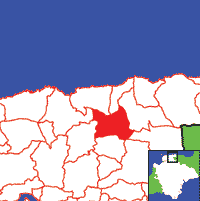
Click on map to view parish boundaries in detail.
Hide
Hide
hide
- History
- Jewish History◬
- Land & Property◬
- Language & Languages◬
- Manors◬
- Maps
- Medical Records◬
- Merchant Marine◬
- Military History◬
- Names, Geographical◬
- Names, Personal
- Newspapers◬
- Occupations◬
- Periodicals◬
- Politics & Government◬
- Poor Houses, Poor Law◬
- Population◬
- Probate Records◬
- Schools
- Social Life & Customs◬
- Societies◬
- Taxation◬
- Voting Registers◬
Hide
"KENTISBURY, a scattered village, in a high situation, 9 miles N.N.E. of Barnstaple, and 3 miles E.S.E. of Combemartin, has in its parish 422 souls, and 3400 acres of land, rising in bold hills, and including the hamlet of Patehole. The manor, formerly belonging to the Wolfe, Randall, Richards, and Beavis families, is dismembered, and the parish now belongs to Earl Fortescue, the Misses Incledon, and several smaller freeholders. The Church is an ancient structure, with a massive tower and four bells." [From White's Devonshire Directory (1850)]
A parish in Braunton Hundred, the Archdeaconry of Barnstaple, and the Diocese of Exeter.
Hide
MIs for this parish are included in the Incledon index - see under Cemeteries on the main Devon page.
Snetzler, M.F. North Devon Surname Index to the Census. Microfiche: M.F. Snetzler. [Covers 1881 census records for this parish]
Parish Registers going back to 1674 are held in the Devon Record Office.
Kentisbury extant PR's at the Devon Record Office, Exeter: Bpt. 1674-1896; Marr 1676-1975; Bur. 1675-1990. (These records also available at the North Devon RO, Barnstaple.)
Transcripts of the Marriages in the Parish Registers going back to 1675 are held in a special collection in the Westcountry Studies Library.
The Devon FHS publishes indexes covering (as of June 2004): Baptisms 1813-1839, Marriages 1754-1841, Burials 1813-1837 - for details see their Devon Parish List.
The members' area of the Devon FHS website makes available online images, not at present (Jan 2016) available elsewhere, of the Parish Registers covering Kentisbury Baptism, marriages, burials: 1675-1812, Baptisms: 1813-1896, Marriages: 1755-1812, Marriages: 1813-1841, Marriages: 1837-1912, Burials: 1813-1912.
Entered into the IGI (as of Jan 1993): Parish Church Marriages 1675-1841.
An index of baptisms, marriages and burials in the parishes of Arlington, Ashford, Berrynarbor, Bittadon, Bratton Fleming, Braunton, Brendon, Challacombe, Charles, Combe Martin, Countisbury, East Buckland, East Down, Georgeham, Goodleigh, Heanton Punchardon, High Bray, Ilfracombe, Kentisbury, Loxhore, Lynton, Martinhoe, Marwood, Mortehoe, Parracombe, Shirwell, Stoke Rivers, Trentishoe, West Buckland and West Down. With photographs of the churches and extracts from White's Directory (1850) and Kelly's Directory of Devonshire (1902), CD-ROM, Exeter, Devon FHS (2015). [Arlington Bapt: 1813-1839, Mar: 1755-1836, Bur: 1814-1837; Ashford Bapt: 1813-1840, Mar: 1747-1837, Bur: 1813-1837; Berrynarbor Bapt: 1813-1839, Mar: 1755-1837, Bur: 1813-1837; Bittadon Bapt: 1813-1843, Mar: 1754-1835, Bur: 1815-1843; Bratton Fleming Bapt: 1813-1840, Mar: 1754-1837, Bur: 1800-1837; Braunton Bapt: 1813-1839, Mar: 1754-1837, Bur: 1813-1837; Brendon Bapt: 1813-1839, Mar: 1754-1837, Bur: 1813-1837; Challacombe Bapt: 1813-1840, Mar: 1754-1837, Bur: 1822-1848; Charles Bapt: 1813-1839, Mar: 1754-1837, Bur: 1813-1837; Combe Martin Bapt: 1813-1840, Mar: 1754-1837, Bur: 1813-1837; Countisbury Bapt: 1813-1839, Mar: 1755-1837, Bur: 1813-1837; East Buckland Bapt: 1813-1838, Mar: 1755-1836, Bur: 1813-1839; East Down Bapt: 1813-1839, Mar: 1754-1839, Bur: 1813-1852; Georgeham Bapt: 1813-1839, Mar: 1754-1837, Bur: 1813-1837; Goodleigh Bapt: 1813-1839, Mar: 1754-1837, Bur: 1813-1837; Heanton Punchardon Bapt: 1813-1839, Mar: 1754-1837, Bur: 1800-1837; High Bray Bapt: 1813-1839, Mar: 1756-1837, Bur: 1813-1837; Ilfracombe Bapt: 1813-1840, Mar: 1754-1837, Bur: 1813-1837; Kentisbury Bapt: 1813-1839, Mar: 1754-1841, Bur: 1813-1837; Loxhore Bapt: 1813-1839, Mar: 1754-1837, Bur: 1813-1837; Lynton Bapt: 1813-1839, Mar: 1754-1837, Bur: 1813-1838; Martinhoe Bapt: 1813-1839, Mar: 1754-1837, Bur: 1813-1839; Marwood Bapt: 1813-1839, Mar: 1754-1837, Bur: 1813-1837; Mortehoe Bapt: 1813-1840, Mar: 1754-1837, Bur: 1750-1837; Parracombe Bapt: 1813-1839, Mar: 1598-1838, Bur: 1813-1838; Shirwell Bapt: 1813-1840, Mar: 1754-1837, Bur: 1813-1837; Stoke Rivers Bapt: 1813-1839, Mar: 1754-1837, Bur: 1813-1839; Trentishoe Bapt: 1813-1839, Mar: 1754-1837, Bur: 1813-1837; West Buckland Bapt: 1813-1840, Mar: 1754-1837, Bur: 1813-1851; West Down Bapt: 1813-1840, Mar: 1754-1837, Bur: 1813-1840.]
Kentisbury parish website.
Section on Kentisbury from Samuel Lewis: A Topographical Dictionary of England (1831), provided by Mel Lockie.
Transcript of complete entry in White's Devonshire Directory of 1850.
The transcription of the section for this parish from the National Gazetteer (1868), provided by Colin Hinson.
- Ask for a calculation of the distance from Kentisbury to another place.
Glanville-Richards, W.S. Richards of Kentisbury, Devon: extracts from the registers of that parish, |Miscellanea Genealogica et Heraldica (New Series) 4, 1884, pp. 17 & 29-30.
Moore-Smith, G.C. Richards of Kentisbury, Co. Devon, Genealogist (New Series) 27, 1911, pp. 78-84.
Kentisbury Catalogue: The Past, Present and Future of "A Parish without a village". Kentisbury Catalogue Steering Group (2000) 180pp.
View a map of the boundaries of this town/parish.
You can see maps centred on OS grid reference SS622438 (Lat/Lon: 51.176783, -3.97272), Kentisbury which are provided by:
- OpenStreetMap
- Google Maps
- StreetMap (Current Ordnance Survey maps)
- Bing (was Multimap)
- Old Maps Online
- National Library of Scotland (Old Ordnance Survey maps)
- Vision of Britain (Click "Historical units & statistics" for administrative areas.)
- English Jurisdictions in 1851 (Unfortunately the LDS have removed the facility to enable us to specify a starting location, you will need to search yourself on their map.)
- Magic (Geographic information) (Click + on map if it doesn't show)
- GeoHack (Links to on-line maps and location specific services.)
- All places within the same township/parish shown on an Openstreetmap map.
- Nearby townships/parishes shown on an Openstreetmap map.
- Nearby places shown on an Openstreetmap map.
Kentisbury contributors to a 1678 brief for the rebuilding of St Paul's Cathedral.