
Hide
Clitheroe
hide
Hide
hide
Hide
hide
Hide
Hide
CLITHEROE, a town, a township, a chapelry, a sub-district: and a district, in Lancashire. The town stands on the river Ribble, and on the Blackburn and Chatburn railway, at the foot of Pendle hill, adjacent to the boundary with Yorkshire, 10 miles NW of Blackburn. The town occupies a rising-ground; contains many modern houses; and presents the ordinary appearance of a seat of manufacture. It has a post office under Blackburn, a railway station with telegraph, a banking office, three chief inns, a moot-hall, a court-house of 1864, two churches, three dissenting chapels, a Roman Catholic chapel, a cemetery of 1862, a mechanics' institute, and a free grammar-school. St. Mary's church has a fine tower and spire, and occupies the site of a previous edifice. St. James' church is a modern structure, in the Norman style, with a tower. Nearly one-third of the inhabitants are employed in extensive paper-works and four cotton factories. The town is a borough by prescription; is governed by a mayor, 4 aldermen, and 12 councillors; sent two members to parliament from the time of Elizabeth till the act of 1832; and now sends one. The municipal borough is conterminate with Clitheroe township; while the parliamentary borough includes also the townships of Twiston, Downham, Chatburn, Worston, Mearley, Pendleton, Wiswall, Whalley, and Little Mitton, all in the parish of Whalley. Direct taxes in 1857, £4,987. Electors in 1868, 484. Pop. of the p. borough in 1841, 11,324; in 1861, 10,864. Houses, 2,247.
John Marius Wilson, Imperial Gazetteer of England and Wales (1870-72) more ...
Hide
Clitheroe Library,
Church Street,
Clitheroe
BB7 2DG
Monumental inscriptions for Clitheroe cemetery, St Mary Magdalene, and for St Michael & St John have been published by the LFH&HS.
Details about the census records, and indexes for Clitheroe.
| St James Church of England, Clitheroe |
| St Mary Magdalene, Clitheroe, Church of England |
| St Paul Church of England, Clitheroe |
| Castle St Congregational, Clitheroe |
| Wellgate Independent, Clitheroe |
| Waddington Rd Cemetery, Clitheroe |
| St Michael and St John Roman Catholic, Clitheroe |
The Register Office covering the Clitheroe area is Ribble Valley.
- Ask for a calculation of the distance from Clitheroe to another place.
In 1835 Clitheroe was a Township and Chapelry in the Parish of Whalley.
The history of Clitheroe from Pigot's Lancashire directory, 1830.
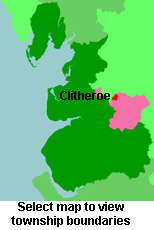
View maps of Clitheroe and places within its boundaries.
View a map of the boundaries of this town/parish.
You can see maps centred on OS grid reference SD743423 (Lat/Lon: 53.875918, -2.391672), Clitheroe which are provided by:
- OpenStreetMap
- Google Maps
- StreetMap (Current Ordnance Survey maps)
- Bing (was Multimap)
- Old Maps Online
- National Library of Scotland (Old Ordnance Survey maps)
- Vision of Britain (Click "Historical units & statistics" for administrative areas.)
- English Jurisdictions in 1851 (Unfortunately the LDS have removed the facility to enable us to specify a starting location, you will need to search yourself on their map.)
- Magic (Geographic information) (Click + on map if it doesn't show)
- GeoHack (Links to on-line maps and location specific services.)
- All places within the same township/parish shown on an Openstreetmap map.
- Nearby townships/parishes shown on an Openstreetmap map.
- Nearby places shown on an Openstreetmap map.
The Workhouse site has an interesting description of Clitheroe workhouse.
For probate purposes prior to 1858, Clitheroe was in the Archdeaconry of Chester, in the Diocese of Chester. The original Lancashire wills for the Archdeaconry of Chester are held at the Lancashire Record Office.
- Lancashire Family History & Heraldry Society - Ribble Valley Branch
- Lancashire Parish Register Society
You can also see Family History Societies covering the nearby area, plotted on a map. This facility is being developed, and is awaiting societies to enter information about the places they cover.