
Hide
Aslackby
hide
Hide
hide
Hide
hide
Hide
Hide
hide
Hide
"GRABY, a hamlet in the parish of Aslackby, wapentake of Aveland, parts of Kesteven, county Lincoln, 2 miles S.E. of Folkingham."
"MILLTHORPE, a hamlet in the parish of Aslackby, wapentake of Aveland, parts of Kesteven, county Lincoln, 3 miles S.E. of Folkingham."
[Transcribed from The National Gazetteer of Great Britain and Ireland 1868]
by Colin Hinson ©2020
Hide
The Library at Bourne will prove useful in your research.
Robert HARVEY has a photograph of some of the enclosed graves at St. James churchyard on Geo-graph, taken in November, 2015.
- Aslackby lies in the Aslackby sub-district of the Bourne Registration District.
- Check our Census Resource page for county-wide resources.
- The table below gives census piece numbers, where known:
| Census Year | Piece No. |
|---|---|
| 1841 | H.O. 107 / 614 |
| 1851 | H.O. 107 / 2095 |
| 1861 | R.G. 9 / 2316 |
| 1871 | R.G. 10 / 3312 |
| 1881 | R.G. 11 / 3196 |
| 1891 | R.G. 12 / 2556 |
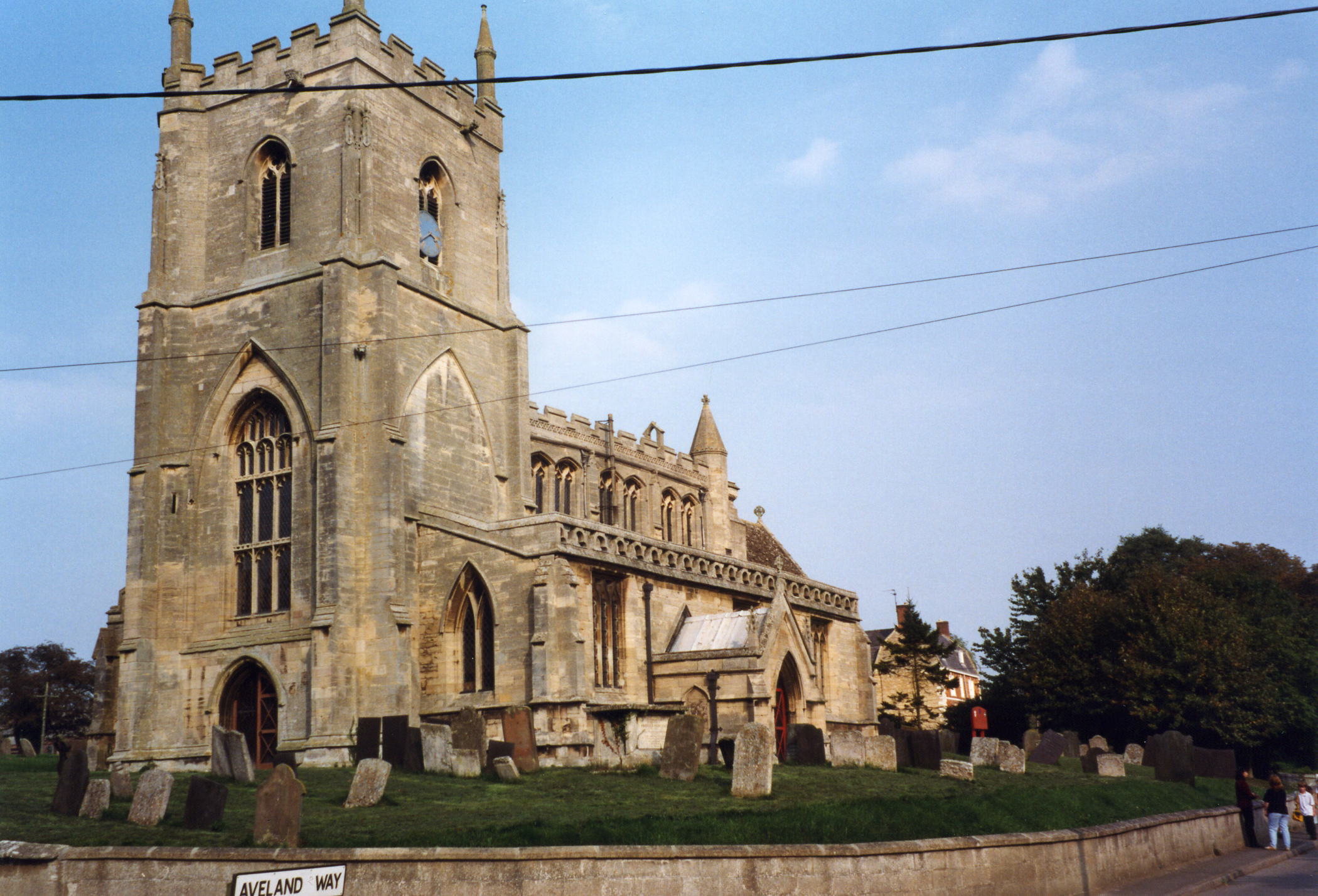
- The Knights Templar had a round church here (circa 1194) portions of which existed until about 1800.
- The Anglican parish church is dedicated to Saint James the Great and is in the Early English and Perpendicular style.
- The church dates from around 1300.
- The church seats 100.
- Richard CROFT has a photograph of St. James' Church on Geo-graph, taken in December, 2005.
- Here is a photograph St. James Church supplied by Ron COLE (who retains the copyright):
- The Anglican parish registers exist from 1558.
- We have only a handful of entries in our Parish Register extract file. Your additions would be welcomed.
- The LFHS has published several indexes for the Aveland and Ness Deanery to make your search easier.
- The Wesleyan Methodists had a small chapel built in 1863. The Baptists built theirs in 1872.
- For information and assistance in researching these chapels, see our non-conformist religions page.
- Check our Church Records page for county-wide resources.
- The parish was in the Aslackby sub-district of the Bourne Registration District.
- Check our Civil Registration page for sources and background on Civil Registration which began in July, 1837.
This village and parish lies between Bourne and Sleaford on the A15 trunk road, 104 miles north of the city of London. Kirkby Underwood parish lies to the south and Folkingham is 2.5 miles to the north. Rippingale parish lies to the south-east. The parish used to include the hamlets of West Graby (or Grayby) & Millthorpe (or Milnthorpe). The parish covers over 3,900 acres of land.
A small creek (part of the Forty Foot Drain) runs past the south side of the village, eventually joining the River Glen near Bourne. If you are planning a visit:
- Roger CALLOW has an aerial photograph of Aslackby village on Geo-graph, taken in September, 2006.
- By automobile, the village is just north of Bourne off of the A15 trunk road.
- See our touring page for area resources.
The National Gazetteer of Great Britain and Ireland - 1868
"GRABY, a hamlet in the parish of Aslackby, wapentake of Aveland, parts of Kesteven, county Lincoln, 2 miles S.E. of Folkingham."
"MILLTHORPE, a hamlet in the parish of Aslackby, wapentake of Aveland, parts of Kesteven, county Lincoln, 3 miles S.E. of Folkingham."
- Ask for a calculation of the distance from Aslackby to another place.
- The parish once had a castle, now long gone, and once was home to the Knights Templar. Temple Farm south-west of the village is another remnant of the Knights Templar.
- Robert HARVEY has a photograph of Aslackby "Castle" on Geo-graph, taken in November, 2015. His caption is enlightning.
- Also near the village is an ancient entrenchment called Aveland, for which the wapentake is reputedly named. Here the Thane kept court in Saxon and Danish times. The encampment is mentioned in the Domesday Survey, but no precise location is given.
- Richard CROFT has a photograph of the Robin Hood and Little John Public House on Geo-graph, taken in November, 2006.
- Robert HARVEY also has a photograph of Robin Hood and Little John Pub. on Geo-graph, taken in January, 2016.
- The "Robin Hood and Little John" pub is an ancient inn, long a stop for travellers on the old Roman Road. These are the names associated with the inn in various directories:
| Year | Person |
|---|---|
| 1829 | Thomas HUGHES, vict. |
| 1842 | Joseph WOOD, vict. |
| 1856 | Joseph Thos. SEATON, gardener & vict. |
| 1861 | John HARE, butcher |
| 1868 | Richard WADSLEY, blacksmith |
| 1872 | Richard WADSLEY, horse dealer |
| 1882 | James HOLLINGSHEAD, vict. |
| 1900 | John BATES |
| 1913 | John BATES |
| 1919 | John BATES |
| 1930 | Chas. GRESSWELL |
Richard WADSLEY, above, was born in Horbling, LIN, around 1833. His wife, Betsey (Betsy) was born in Dunsby, LIN, a year earlier.
James HOLLINGSHEAD, above, was born in Grimstone, LEI, circa 1812. His wife, Mary, was born in Arnold, LIN, circa 1822. They had at least six children, all born in Grantham, LIN.
David HOWARD has a photograph of the motel associated with the Robin Hood on Geo-graph, taken in January, 2018.
- Aslackby Manor House was the residence of Anthony DALE during the period from 1850 to 1870.
- Benjamin Nightingale SMITH was the resident in 1919.
- Rex NEEDLE has a photograph of the Manor House on Geo-graph, taken in July, 2000.
- See our Maps page for additional resources.
You can see maps centred on OS grid reference TF085303 (Lat/Lon: 52.859264, -0.389929), Aslackby which are provided by:
- OpenStreetMap
- Google Maps
- StreetMap (Current Ordnance Survey maps)
- Bing (was Multimap)
- Old Maps Online
- National Library of Scotland (Old Ordnance Survey maps)
- Vision of Britain (Click "Historical units & statistics" for administrative areas.)
- English Jurisdictions in 1851 (Unfortunately the LDS have removed the facility to enable us to specify a starting location, you will need to search yourself on their map.)
- Magic (Geographic information) (Click + on map if it doesn't show)
- GeoHack (Links to on-line maps and location specific services.)
- All places within the same township/parish shown on an Openstreetmap map.
- Nearby townships/parishes shown on an Openstreetmap map.
- Nearby places shown on an Openstreetmap map.
- The clock on the church tower is a memorial to the men of the parish who fell in World War I. It was added in 1920.
- Robert HARVEY has a photograph of the Clock Memorial on Geo-graph, taken in November, 2015.
- There is a photograph of the Clock Memorial Plaque on SLHA site, taken in October 2017. No servicemen names are listed.
- Tony HIBBERD has a photograph of the top of the WWII War Memorial on Geo-graph, taken in April, 2013.
- Tony HIBBERD also has a photograph of the US Military Units that participated on Geo-graph, taken in April, 2013.
For a photograph of the Aslackby War Memorial and a list of the names on the plaque, see the Roll of Honour site.
- In the 1086 Domesday Book the village name is rendered as Aslachebi, from the Old Scandinavian Aslakr+by meaning "village of a man called Aslakr".
[A. D. Mills, "A Dictionary of English Place-Names," Oxford University Press, 1991]
- Locals pronounce the name of the village as Azelby or Aiselbee.
- Others pronounce the name of the village as As ulk bee or Ais ul bi.
- Anne COLE reports finding the name of the village as Asleby on a marriage bond.
- This place was an ancient parish in Lincoln county and became a modern Civil Parish when those were established.
- The parish was in the ancient Aveland Wapentake in the South Kesteven district in the parts of Kesteven.
- You may contact the local "Joint" Parish Council (Laughton and Aslackby) about civic and political issues, but they are NOT staffed to answer family history questions.
- For today's district governance, contact the South Kesteven District Council.
- The Civil Parish was abolished in 1936 as part of a government re-organisation and merged with Laughton Civil Parish.
- Bastardy cases would be heard in the Bourne petty session hearings.
- The Brownlow Charity generated £4 in 1919 and was used to purchase fuel for the poor.
- The parish had its own poorhouse, but I have no details on its history. Chris has a photograph of the Former workhouse on Geo-graph, taken in July, 2019.
- After the 1834 Poor Law Amendment Act reforms, the parish became a part of the Bourne Poor Law Union.
- The children of the parish went to a school built here in 1850. The school was enlarged in 1874 to hold 90 children. In 1911, about 50 children attended the school.
- For more on researching school records, see our Schools Research page.