
Hide
Carlton le Moorland
hide
Hide
hide
Hide
hide
Hide
Hide
[Transcribed from The National Gazetteer of Great Britain and Ireland 1868]
by Colin Hinson ©2020
Hide
The Library at Newark on Trent will prove useful in your research.
J. THOMAS has a photograph of St. Mary's churchyard gravestones on Geo-graph, taken in April, 2012.
- The parish was in the Bassingham sub-district of the Newark Registration District.
- Check our Census Resource page for county-wide resources.
- The table below gives census piece numbers, where known:
| Census Year | Piece No. |
|---|---|
| 1841 | H.O. 107 / 616 |
| 1861 | R.G. 9 / 2477 |
| 1871 | R.G. 10 / 3540 |
| 1891 | R.G. 12 / 2712 |
| Carlton le Moorland, Society of Friends (Quaker) |
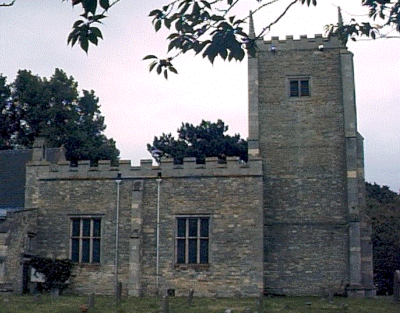
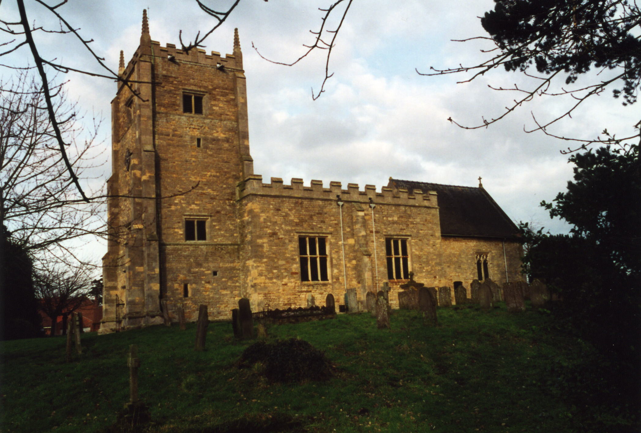
- The Anglican parish church is dedicated to Saint Mary the Virgin and was once affiliated with Thorton Abbey near Barton upon Humber.
- The age of the church is uncertain, with some parts of apparent Norman origin.
- The building was restored in 1890-91.
- Julian P. GUFFOGG has a photograph of the East Window from the restoration on Geo-graph, taken in January, 2016.
- A clock was placed in the tower in 1902 to commemorate the coronation of King Edward VII.
- The church contains brass tablets as memorials to members of the DISNEY family, dated 1595 and 1611.
- The church seats about 130.
- Tim HEATON has a photograph of the Church of St. Mary on Geo-graph, taken in July, 2014.
- Richard CROFT also has a photograph of St. Mary's Church on Geo-graph, taken in September, 2005.
- Here is a photo of the Anglican parish church, taken by (and copyright of) Wendy PARKINSON:
- Here is a photo of the church, taken by Ron COLE (who retains the copyright):
- The parish register dates from 1561.
- The LFHS has published several indexes (marriage and burial) for the Graffoe Deanery to make your search easier.
- Parish registers are on file at the Society of Genealogists, covering 1561 - 1812.
- We have the very beginnings of a Parish Register Extract in a pop-up text file. Your additions and corrections are welcomed.
- The Wesleyan Methodists built a chapel built here in 1863. This chapel is now a private residence.
- Jonathan THACKER has a photograph of the former Methodist Chapel on Geo-graph, taken in February, 2011.
- The Baptists had a chapel erected here prior to 1872 with an associated burial ground. CHRIS ? has a photograph of the former Baptist Chapel on Geo-graph, taken in April, 2015.
- The Quakers also met here. For information and assistance in researching these chapels, see our non-conformist religions page.
- Check our Church Records page for county-wide resources.
- The parish was in the Bassingham sub-district of the Newark Registration District.
- Check our Civil Registration page for sources and background on Civil Registration which started in July, 1837.
Carlton-le-Moorland (sometimes given as "Carlton le Moorlands" - note the trailing "S") is both a village and parish. It lies north of the A17 trunk road, northeast of Newark on Trent, 11 miles SSW of Lincoln. It has Bassingham parish lying to the north and Norton Disney to the northwest. The River Witham forms a portion of the parish's northwest boundary, crossed by the Scotwater Bridge, while the River Brant touches the eastern side. The parish covers just over 2,250 acres of good farmland.
The village dates back to at least 1068. Today it is still a small village, retaining many of the old buildings from past centuries. If you are planning a visit:
- Richard CROFT has a photograph of the Village Pond on Geo-graph, taken in April, 2011,
- Visit our touring page for more sources.
- Ian S. has a photograph of the Village Sign on Geo-graph, taken in June, 2012.
The National Gazetteer of Great Britain and Ireland - 1868
- Ask for a calculation of the distance from Carlton le Moorland to another place.
- At the Lincoln Archives there is a history of Carlton Le Moorland and Norton Disney 1540-1615, by Judith R. Jones, which is available by request. It was written as part of her university thesis in 1987 and contains useful info about the village and various individuals. Included are inventories at death, wills, a map of the village in 1667, etc. There is a copy at the Lincoln Archives and at the Hayward Library, University of Nottingham.
- In the 1980s, after the last of the BROCKLEBANK families died off, a number of people bought and built new homes in the parish.
- Paul FARMER has a photograph of the White Hart Inn on Geo-graph, taken in November, 2011.
- J. THOMAS also has a photograph of the White Hart Pub. on Geo-graph, taken in April, 2012.
- The White Hart pub is 16th century in origins, though there used to be at least two.
- Jonathan THACKER has a photograph of The Manor on Geo-graph, taken in February, 2011.
- See our "Maps page for additional resources.
You can see maps centred on OS grid reference SK907581 (Lat/Lon: 53.111957, -0.64579), Carlton le Moorland which are provided by:
- OpenStreetMap
- Google Maps
- StreetMap (Current Ordnance Survey maps)
- Bing (was Multimap)
- Old Maps Online
- National Library of Scotland (Old Ordnance Survey maps)
- Vision of Britain (Click "Historical units & statistics" for administrative areas.)
- English Jurisdictions in 1851 (Unfortunately the LDS have removed the facility to enable us to specify a starting location, you will need to search yourself on their map.)
- Magic (Geographic information) (Click + on map if it doesn't show)
- GeoHack (Links to on-line maps and location specific services.)
- All places within the same township/parish shown on an Openstreetmap map.
- Nearby townships/parishes shown on an Openstreetmap map.
- Nearby places shown on an Openstreetmap map.
- The parish war memorial is the lychgate which is the main entrance to the churchyard. The lychgate built of Old English Oak was added in October, 1920, and the brass plaques were added shortly after.
- There is also a brass plaque inside the Anglican church which was relocated from the Methodist chapel.
The Newark Great War Bulletin for January 1st, 1915 tells us Fred CARR volunteered to fight in the Great War (in the Sherwood Rangers).
The Newark Great War Bulletin for November 22nd, 1915 tells us that trooper Joseph Hugh Turner BROCKLEBANK of the Lincolnshire Yeomanry died when the HMS Mercian was shelled by a German submarine. The Mercian was a fruit hauler converted to transport troops and horses. She carried no armament to fight back. The Mercian made harbour in Oran and buried her dead in the local cemetery.
The Parish Council provides a Portable Document File (requires Adobe Reader) on the Lychgate and the men whose names are inscribed on it.
- Carlton is Nordic or Old English for ceorl or freemen. Le Moorland comes from the Normans. The D'Isney family were up the road at Norton Disney and came over with William in 1066. The village gets a mention in the 1068 Doomsday book as Carletune.
["A Dictionary of English Place-Names," A. D. MILLS, Oxford University Press, 1991]
The following surnames were found in the 1872 White's Directory of Lincolnshire under this parish:
ASH, BALDOCK, BINGLEY, BRADLEY, BROCKLEBANK, BRUMBY, BURN, CARR, CARTER, COLLEY, GARRETT, HARRIS, HOLLIS, HUTCHINSON, KEEP, MARSHALL, MUSSON, PIGGOTT, REYNOLDS, SAYWELL, SIBSEY, SMITH, THOMPSON, TONGE, TOPHAM, WASS, WILLIAMS, WORSDALL and WRIGHT.
The following surnames were found in the 1913 Kelly's Directory of Lincolnshire under this parish:
ASH, BARBER, BROCKLEBANK, BROWITT, CARR, DARKER, DOLPHIN, HARWOOD, LOWE, MARSHALL, MILLINGTON, PRIESTLY, SCATLIFF, SCOTT, SIMS, SKINNER, WALTON and YATES.
- This place was an ancient parish in Lincoln county and became a modern Civil Parish when those were established.
- The parish was in the ancient Boothby Graffoe Wapentake in the North Kesteven division of the county, in the parts of Kesteven.
- You may contact the local Parish Council regarding civic or political issues, but they are NOT staffed to help you with family history searches.
- For today's district governance, see the North Kesteven District Council.
- Bastardy cases would be heard in the Lincoln South petty session hearings.
- In 1701, enclosure brought a little over 2 acres and 3 rods of land to be let, the revenue to go to the poor.
- In 1707 John JESSOP left £30 for both the school and for the poor.
- About 1762, an additional £30 was used to purchase land, the lease revenue to go to the poor. That donation came from Rev. SMITH and William EASTLAND.
- After the Poor Law Amendment Act reforms of 1834, the parish became part of the Newark Poor Law Union.
- In 1846, Mr. Joseph BROCKLEBANK left the interest on £100 for the school and the poor.
- In 1820, Mrs. BROCKLEBANK left the interest on £100 for the support of a Sunday School.
- A public elementary school was erected here in 1854, funded by subscription, with room for 80 children, with attendance averaging at 51.
- The school received a yearly gratuity of £15 from Lord Middleton.
- For more on researching school records, see our Schools Research page.