
Hide
Clixby
hide
Hide
hide
Hide
hide
Hide
Hide
Clixby, township, Caistor par., N. Lincolnshire, on the Wolds, 2 miles NW. of Caistor, pop. 45.
From: John BARTHOLOMEW's "Gazetteer of the British Isles (1887)"
Hide
The nearby Caistor Library is an excellent resource with a Local History section and a Family History section.
Chris MORGAN has a photograph of All Hallows church graveyard on Geo-graph, taken in February, 2018.
- The parish was in the Caistor sub-district of the Caistor Registration District.
- Check our Census Resource page for county-wide resources.
- The table below gives census piece numbers, where known:
| Census Year | Piece No. |
|---|---|
| 1841 | H.O. 107 / 630 |
| 1851 | H.O. 107 / 2114 |
| 1861 | R.G. 9 / 2392 |
| 1871 | R.G. 10 / 3421 |
| 1891 | R.G. 12 / 2621 |
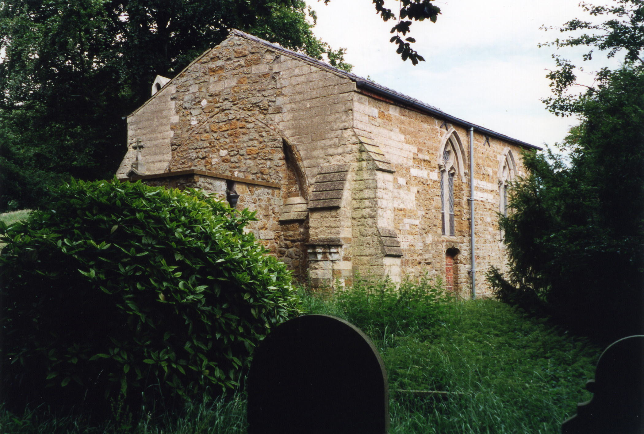
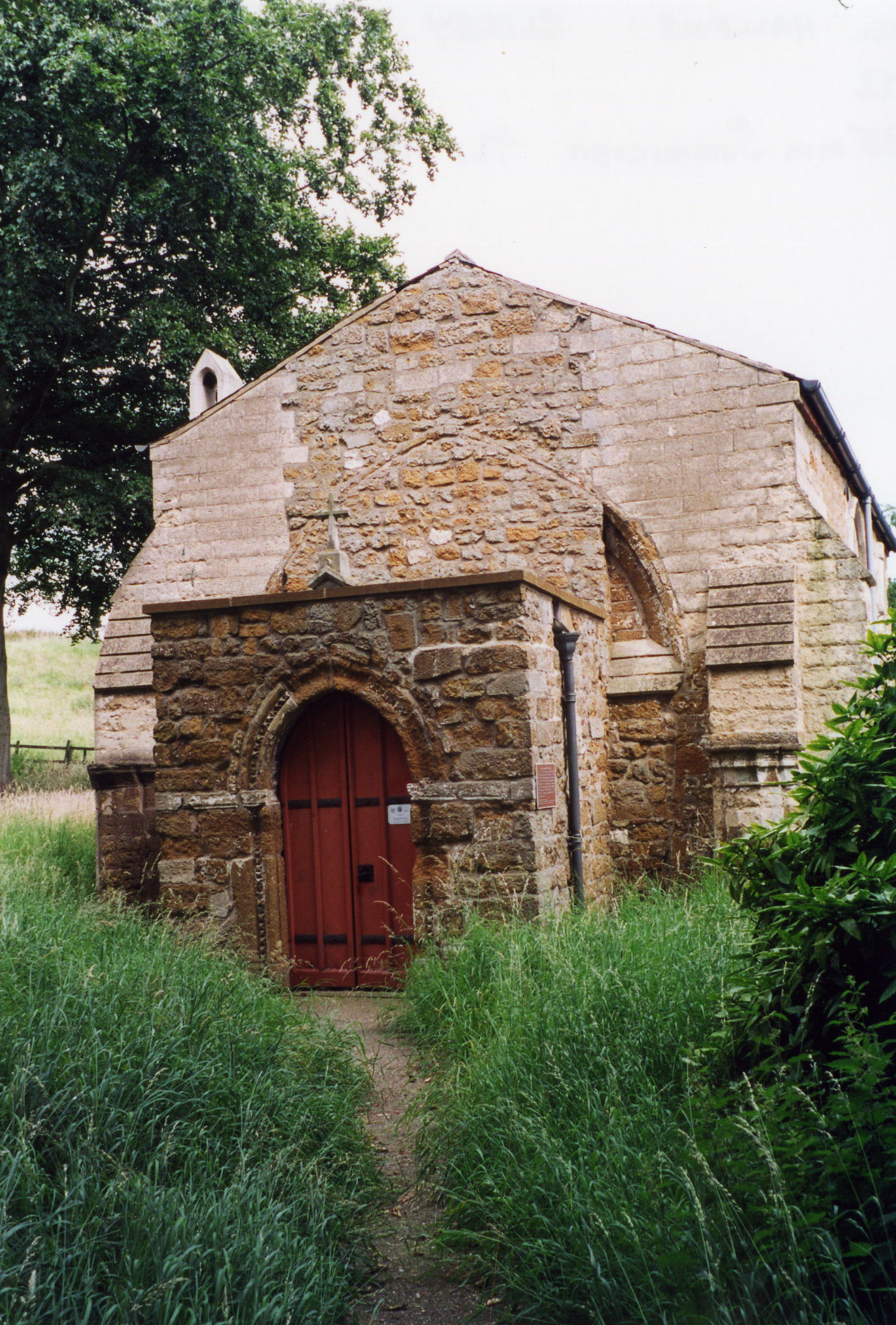
- The Anglican parish church is dedicated to All Hallows.
- In 1871, the church was a small building, comprising only the chancel of the original church.
- The church was restored in 1889.
- The church seats 128.
- The Diocese of Lincoln declared this church redundant in July, 1973.
- There is a photograph of All Hallows church on the Wendy PARKINSON Church Photos web site
- David HITCHBORNE has a photograph of All Hallows Church on Geo-graph, taken in July, 2004.
- Here are two photos of All Hallows Church, taken by Ron COLE (who retains the copyright):
- The Anglican parish register is included in that of Caistor.
- The Lincolnshire FHS has published several marriage indexes and a burial index for the Westwold Deanery to make your search easier.
- Check our Church Records page for county-wide resources.
- The parish was in the Caistor sub-district of the Caistor Registration District.
- Check our Civil Registration page for sources and background on Civil Registration which began in July, 1837.
Clixby is a small village and a parish about 2 miles north of Caistor. Caistor parish is to the south and Great Limber parish to the north.
If you are planning a visit:
- See our touring page for visitor services.
- Ask for a calculation of the distance from Clixby to another place.
- See our Maps page for additional resources.
You can see maps centred on OS grid reference TA103047 (Lat/Lon: 53.527034, -0.337593), Clixby which are provided by:
- OpenStreetMap
- Google Maps
- StreetMap (Current Ordnance Survey maps)
- Bing (was Multimap)
- Old Maps Online
- National Library of Scotland (Old Ordnance Survey maps)
- Vision of Britain (Click "Historical units & statistics" for administrative areas.)
- English Jurisdictions in 1851 (Unfortunately the LDS have removed the facility to enable us to specify a starting location, you will need to search yourself on their map.)
- Magic (Geographic information) (Click + on map if it doesn't show)
- GeoHack (Links to on-line maps and location specific services.)
- All places within the same township/parish shown on an Openstreetmap map.
- Nearby townships/parishes shown on an Openstreetmap map.
- Nearby places shown on an Openstreetmap map.
- For centuries Clixby was only a township and a parochial chapelry in Caistor parish.
- Clixby was incorporated as a separate, modern Civil Parish in December, 1866.
- The parish was in the ancient Yarborough Wapentake in the West Lindsey district in the parts of Lindsey.
- In April 1936 the civil parish was dissolved and the area allocated to Grasby civil parish.
- Another source tells us that the parish was amalgamated into Caistor parish in 1932.
- Today's district governance is provided by the West Lindsey District Council.
- Bastardy cases would be heard in the Caistor petty session hearings.
- After the Poor Law Amendment Act of 1834, this parish became part of the Caistor Poor Law Union.
- The children of this parish attended Grasby School.
- For more on researching school records, see our Schools Research page.