
Hide
Conisholme
hide
Hide
hide
Hide
hide
Hide
Hide
Hide
The Library at Louth will prove useful in your research.
- The parish was in the Saltfleet sub-district of the Louth Registration District.
- Check our Census Resource page for county-wide resources.
- The table below gives census piece numbers, where known:
| Census Year | Piece No. |
|---|---|
| 1841 | H.O. 107 / 631 |
| 1851 | H.O. 107 / 2112 |
| 1861 | R.G. 9 / 2385 |
| 1871 | R.G. 10 / 3408 |
| 1891 | R.G. 12 / 2610 |
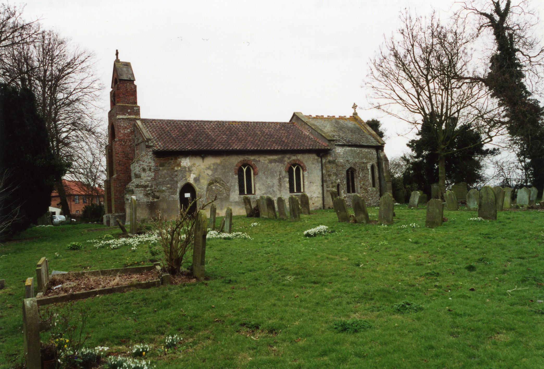
- The Anglican parish church was built of chalk-stone and dedicated to Saint Peter.
- Portions of the church date to the 13th century.
- The church was restored in 1853 and a new bell-tower added.
- The church chancel was restored again in 1876.
- The church seats 80.
- Richard CROFT has a photograph of St. Peter's belicote on Geo-graph, taken in May, 2007.
- Here is a photograph St. Peter's Church supplied by Ron COLE (who retains the copyright):
- The Anglican parish registry dates from 1559.
- The Lincolnshire FHS has published several Marriage indexes and a Burial index for the Louthesk Deanery to make your search easier.
- The United Methodists built a chapel here in 1849 and the Free Methodists built one in 1856.
- Chris ? has a photograph of the Free Methodist chapel on Geo-graph, taken in September, 2012.
- Richard CROFT also has a photograph of the Conisholme Methodist Chapel on Geo-graph, taken in May, 2007.
- For information and assistance in researching these chapels, see our non-conformist religions page.
- Check our Church Records page for county-wide resources.
- The parish was in the Saltfleet sub-district of the Louth Registration District.
- Check our Civil Registration page for sources and background on Civil Registration which began in July, 1837.
Conisholme is both a village and a parish about 4 miles inland from the North Sea and 8 miles north-west of Louth. Grainthorpe parish is to the north. The old River Lud used to flow through the parish, but its waters have been diverted into the Louth Navigation Canal. The parish covers 1,240 acres.
If you are planning a visit:
- If you need a cool refreshment, stop in at Appleby's Ice Cream parlour on the A1031 road.
- See the Lincolnshire Touring and Holidays page on this site.
- Ask for a calculation of the distance from Conisholme to another place.
- See our Maps page for additional resources.
You can see maps centred on OS grid reference TF402956 (Lat/Lon: 53.438634, 0.108919), Conisholme which are provided by:
- OpenStreetMap
- Google Maps
- StreetMap (Current Ordnance Survey maps)
- Bing (was Multimap)
- Old Maps Online
- National Library of Scotland (Old Ordnance Survey maps)
- Vision of Britain (Click "Historical units & statistics" for administrative areas.)
- English Jurisdictions in 1851 (Unfortunately the LDS have removed the facility to enable us to specify a starting location, you will need to search yourself on their map.)
- Magic (Geographic information) (Click + on map if it doesn't show)
- GeoHack (Links to on-line maps and location specific services.)
- All places within the same township/parish shown on an Openstreetmap map.
- Nearby townships/parishes shown on an Openstreetmap map.
- Nearby places shown on an Openstreetmap map.
- In the churchyard is a Cornish granite cross erected in memory of those who fell in the Great War of 1914-1918.
- Ian S. has a photograph of the War Memorial in the churchyard on Geo-graph, taken in November, 2013.
- Ian also has a photograph of the base of the War Memorial on Geo-graph, taken in November, 2013.
Ludney is a hamlet just northwest of Conishome, named after the River Ludd. The River Ludd, alas, no longer flows in its natural glory here.
- This place was an ancient parish in Lincoln county and it became a modern Civil Parish when those were established.
- The parish was in the Marsh division of the ancient Louth Eske Wapentake in the East Lindsey district in the parts of Lindsey.
- The citizens of Conisholme have elected to forgo a formal Parish Council. They have Parish Meetings to discuss politcal and civic issues.
- For today's district governance, see the East Lindsey District Council.
- Bastardy cases would be heard in the Louth petty session hearings.
- After the 1834 Poor Law Amendment Act reforms, this parish became part of the Louth Poor Law Union.
- A Public Elementary School was built here in 1854. It was enlarged in 1877 to hold 40 children.
- For more on researching school records, see our Schools Research page.