
Hide
East Halton
hide
Hide
hide
Hide
hide
Hide
Hide
[Transcribed from The National Gazetteer of Great Britain and Ireland 1868]
by Colin Hinson ©2020
Hide
The Barton-on-Humber Library is an excellent resource with a Local History section and a Family History section.
- The parish was in the Barton sub-district of the Glanford Brigg Registration District
- Check our Census Resource page for county-wide resources.
- The table below gives census piece numbers, where known:
Census
YearPiece No. 1841 H.O. 107 / 636 1861 R.G. 9 / 2402 1871 R.G. 10 / 3435 1891 R.G. 12 / 2629
- Below is a partial list of surnames found in the East Halton 1901 census returns, provided by Alistair CHAFER.:
|
|
|
|
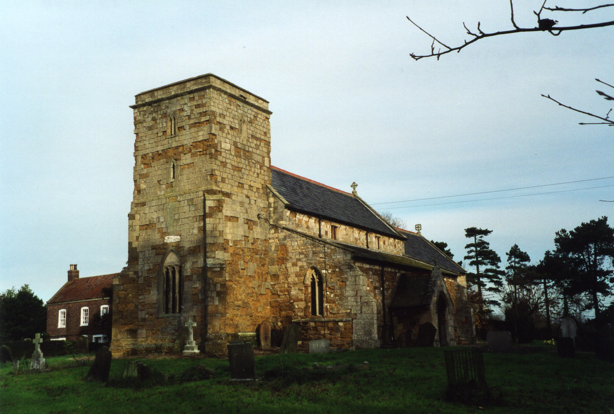
- The Anglican parish church is dedicated to Saint Peter and was built in the 13th Century.
- The church was completely restored in 1868 by James FOWLER of Louth. LIN.
- The church is a Grade II structure with English Heritage.
- The church seats 280.
- There is a photograph of Saint Peter's church on the Wendy PARKINSON Church Photos web site, taken by Paul Fenwick.
- Here is a photo of the St Peter's Church, taken by (and copyright of) Ron COLE.
- The Anglican parish registers exist from 1574.
- The Bishop's Transcripts exist from 1561 through 1845 and can be found at the Family History Library.
- Those researching the ROBINSON surname will want to check our parish register extract. Your additions are welcome.
- The parish is in the Haverstoe Deanery, for which several indexes exist. The parish has also been in the Yarborough Deanery.
- The Wesleyan Methodists and Primitive Methodists both had chapels in the parish. There were Wesleyans in East Halton as early as 1791, and they built their chapel here in 1805. In 1814 they had 35 members. The Wesleyan chapel was replaced in 1889. The Primitive Methodists erected their chapel in 1878. For information and assistance in researching these chapels, see our non-conformist religions page.
- Jonathan THACKER has a photograph of the East Halton Methodist Church on Geo-graph, taken in July, 2011. Alas, he does not tell us which denomination it served.
- Check our Church Records page for county-wide resources.
- The parish was in the Barton sub-district of the Glanford Brigg Registration District.
- Check our Civil Registration page for sources and background on Civil Registration which began in July, 1837.
This village and parish are on the south side of the Humber River, almost due south from Kingston Upon Hull. Seven and a half miles to the east is Barton upon Humber and down the coast is Grimsby. The parish to the northwest is Goxhill. To the south lies North Killingholme parish.
The village of East Halton lies about a mile from the Humber and can be reached by taking the A180 trunk road and turning north onto the A160 and turning off at South Killingholme. In White's 1872 Directory, the village is described as "widely-scattered". A small creek runs along the north edge of the parish out to the Humber, called Halton Skitter. The Skitter Sand silt bed runs along the river bank. The land is low and sometimes marshy, but the soil is rich and fertile. East Halton is a small parish, covering about 3,920 acres of land (3,321 in 1911).
Make sure you are researching the right place. There is a Halton East in North Yorkshire and a Halton in Lancaster and in other places around England. If you are planning a visit:
- Visitors are invited to stop at the Black Bull Inn.
- Bus service is via Carlberry Company.
- Passenger rail service stopped in 1963.
- Use our touring page for area resources.
The National Gazetteer of Great Britain and Ireland - 1868
- Ask for a calculation of the distance from East Halton to another place.
- Bricks were made at East Halton, perhaps as far back as Saxon times.
- Like many of the villages which lie on the south bank of the River Humber, there was a ferry service to the north bank, a twice weekly sailing across to Hull itself on Tuesdays and Fridays.
- Historically a farming and livestock-raising area, the 20th Century brought oil terminals and storage to the parish.
- See our Maps page for additional resources.
You can see maps centred on OS grid reference TA139199 (Lat/Lon: 53.663408, -0.277662), East Halton which are provided by:
- OpenStreetMap
- Google Maps
- StreetMap (Current Ordnance Survey maps)
- Bing (was Multimap)
- Old Maps Online
- National Library of Scotland (Old Ordnance Survey maps)
- Vision of Britain (Click "Historical units & statistics" for administrative areas.)
- English Jurisdictions in 1851 (Unfortunately the LDS have removed the facility to enable us to specify a starting location, you will need to search yourself on their map.)
- Magic (Geographic information) (Click + on map if it doesn't show)
- GeoHack (Links to on-line maps and location specific services.)
- All places within the same township/parish shown on an Openstreetmap map.
- Nearby townships/parishes shown on an Openstreetmap map.
- Nearby places shown on an Openstreetmap map.
- East Halton had an inauspicious start in its military role. A balloon headquarters started in a semi-derelict farmhouse just north of the village in early World War II. The area was still rural. There was mains electricity, but no piped water or sanitary drains. Those improvements came shortly after the war.
- The government wished to protect the oil tanks in the area, as well as the important railway lines. Balloon units were seen as an important defense mechanism.
- During World War II, the RAF had a balloon squadron stationed here. Some traces of it remain in the parish.
- Olivia READY lived in the farmhouse/balloon HQ from 1946 to 1964 after her father, Robert ATWOOD bought it. She tells us it had a brick wall built outside each downstairs window to minimize bomb blast damage. There was a water tower at the rear. During the war, the house was surrounded by Nissan huts.
- The East View Dog Kennels and Cattery are housed in the old stores building.
- The name Halton is common in England and comes from Old English halh+tun meaning "farmstead in a nook or corner". In the 1086 Domesday Book, the name appears as Haltune.
[A. D. MILLS, "A Dictionary of English Place-Names," Oxford University Press, 1991]
- Olivia READY tells us that the BYGOTT and COULSON families were residents of East Halton from the 1700's, many of their descendants are still living locally. By her Will of 1750, Elizabeth COULSON left her 5 grandchildren a swarm of bees each.
- A Richard COULSON is listed as a tailor in White's Directory of Lincolnshire for 1842, as are farmers John and Robert BYGOTT.
- This place was an ancient parish in Lincoln county and became a modern Civil Parish when those were established.
- The parish was in the ancient Yarborough Wapentake in the Glanford district in the parts of Lindsey.
- You may contact the East Halton Parish Council regarding civic or political matters, but they are NOT funded to help you with Family History searches.
- For today's district governance, see the North Lincolnshire Council website.
- When it is open, stop in at the Village Hall here photographed by J. THOMAS, taken in March, 2013. Ask for a copy of the schedule of forth-coming events.
- The Common Lands were enclosed here around 1796.
- After the Poor Law Amendment Act reforms of 1834, East Halton became part of the Glanford Brigg Poor Law Union.
- Bastardy cases would be heard at the Barton-on-Humber petty session hearings every other Monday.
Year Inhabitants 1801 350 1811 478 1821 468 1831 515 1841 627 1851 675 1861 727 1871 673 1881 647 1891 505 1901 493 1911 567 1921 662 1931 628 2001 604
- There is no history of when the first school was built here, but a board school, built of brick, was erected in 1878. Currently, East Halton Primary School is a small school about five miles from Immingham with about 62 students.
- Ian S. has a photograph of East Halton Primary School on Geo-graph, taken in September, 2017.
- See our Schools page for more information on researching school records.