
Hide
Irby in the Marsh
hide
Hide
hide
Hide
hide
Hide
Hide
"IRBY-IN-THE-MARSH, a parish in the hundred of Candleshoe, parts of Lindsey, county Lincoln, 5 miles S.E. of Spilsby, its post town, and 3 S.W. of Burgh. It is situated near the river Steeping, and within a short distance of the Firsby railway station. The parish formerly belonged to the Irbys, now lords Boston. It is intersected by the road from Spilsby to Wainfleet. The village is small and wholly agricultural. The tithes have been commuted for a rent-charge of £105. The living is a perpetual curacy in the diocese of Lincoln, value £83, in the patronage of the Dean and Chapter of Lincoln. The church, dedicated to All Saints, is of considerable antiquity, and has a low tower. The Wesleyans and Primitive Methodists have each a chapel. There is a National school. Irby shares equally with Burgh-le-Marsh in Holden's charity."
[Transcribed from The National Gazetteer of Great Britain and Ireland 1868]
by Colin Hinson ©2020
Hide
- The parish was in the Burgh sub-district of the Spilsby Registration District.
- Check our Census Resource page for county-wide resources.
- The table below gives census piece numbers, where known:
| Census Year | Piece No. |
|---|---|
| 1841 | H.O. 107 / 638 |
| 1851 | H.O. 107 / 2110 |
| 1861 | R.G. 9 / 2376 |
| 1871 | R.G. 10 / 3394 |
| 1891 | R.G. 12 / 2604 |
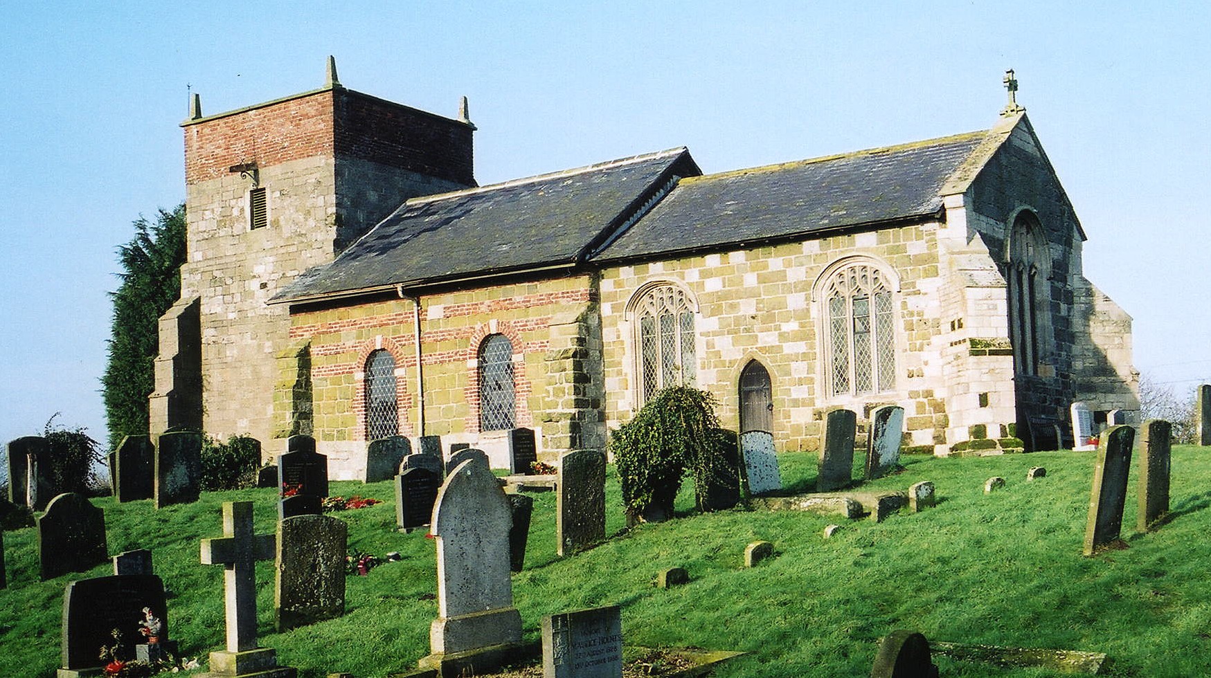
- The Anglican parish church is dedicated to All Saints.
- The church is built of sandstone and brick and was restored in 1863, then partially rebuilt in 1886.
- The church only seats about 95 people.
- A photograph of the Anglican church is at the Wendy PARKINSON English Church Photographs site.
- Rodney BURTON has a photograph of All Saints Church on geo-graph, taken in March, 2004.
- Here is a photo of All Saints Church, taken by Ron COLE (who retains the copyright):
- The Anglican parish register dates from 1539.
- The Lincolnshire FHS has published several marriage indexes and a burial index for the Calcewaith & Candleshoe Deanery to make your search easier.
- A Primitive Methodist chapel was built here in 1837 and Wesleyan Methodist chapel was built here in 1889.
- David HITCHBORNE has a photograph of a portion of the Wesleyan Methodist chapel on geo-graph, taken in June, 2007.
- For information and assistance in researching Methodist chapels, see our non-conformist religions page.
- Check our Church Records page for county-wide resources.
- The parish was in the Burgh sub-district of the Spilsby Registration District.
- Check our Civil Registration page for sources and background on Civil Registration which started in July, 1837.
This village and small parish are 125 miles north of London and 5 miles east south-east of Spilsby. Firsby parish lies to the west and Bratoft parish to the east. The parish only covers about 770 acres.
If you are planning a visit:
- By automobile, take the B1195 arterial road east out of Spilsby toward Wainfleet for about 5 miles.
- Visit our touring page for more sources.
The National Gazetteer of Great Britain and Ireland - 1868
"IRBY-IN-THE-MARSH, a parish in the hundred of Candleshoe, parts of Lindsey, county Lincoln, 5 miles S.E. of Spilsby, its post town, and 3 S.W. of Burgh. It is situated near the river Steeping, and within a short distance of the Firsby railway station. The parish formerly belonged to the Irbys, now lords Boston. It is intersected by the road from Spilsby to Wainfleet. The village is small and wholly agricultural. The tithes have been commuted for a rent-charge of £105. The living is a perpetual curacy in the diocese of Lincoln, value £83, in the patronage of the Dean and Chapter of Lincoln. The church, dedicated to All Saints, is of considerable antiquity, and has a low tower. The Wesleyans and Primitive Methodists have each a chapel. There is a National school. Irby shares equally with Burgh-le-Marsh in Holden's charity."
- Ask for a calculation of the distance from Irby in the Marsh to another place.
- See our Maps page for additional resources.
You can see maps centred on OS grid reference TF469638 (Lat/Lon: 53.150683, 0.195694), Irby in the Marsh which are provided by:
- OpenStreetMap
- Google Maps
- StreetMap (Current Ordnance Survey maps)
- Bing (was Multimap)
- Old Maps Online
- National Library of Scotland (Old Ordnance Survey maps)
- Vision of Britain (Click "Historical units & statistics" for administrative areas.)
- English Jurisdictions in 1851 (Unfortunately the LDS have removed the facility to enable us to specify a starting location, you will need to search yourself on their map.)
- Magic (Geographic information) (Click + on map if it doesn't show)
- GeoHack (Links to on-line maps and location specific services.)
- All places within the same township/parish shown on an Openstreetmap map.
- Nearby townships/parishes shown on an Openstreetmap map.
- Nearby places shown on an Openstreetmap map.
- This place was an ancient parish in Lincoln county and became a modern Civil Parish when those were established.
- The parish was in the Wold division of the ancient Candleshoe Wapentake in the East Lindsey district in the parts of Lindsey.
- In March, 1888, this Civil Parish gained a portion of Firsby Civil Parish, but it lost over 300 acres in parish boundary changes.
- You can contact the local Joint Parish Council about civic or political issues, but they are NOT staffed to answer family history questions. The Joint Council includes Bratoft, Firsby, Great Steeping, Irby in the Marsh and Little Steeping.
- Kelly's 1900 Directory of Lincolnshire places the parish in the South Lindsey division of the county.
- For today's district governance, see the East Lindsey District Council.
- Bastardy cases would be heard in the Spilsby petty session hearings every other Monday.
- In 1503 John HOLDEN left by will 54 acres of land to let for charitable purposes.
- After the 1834 Poor Law Amendment Act reforms, the parish became part of the Spilsby Poor Law Union.
- The first school was built here in 1844, funded by Holden's Charity.
- A School Board was formed in the parish on 10 March 1876 and the district included Firsby, Bratoft and Irby in the Marsh.
- A Board School was built in 1880 to hold up to 100 children.
- See our Schools page for more information on researching school records.