
Hide
Kirkby la Thorpe
hide
Hide
hide
Hide
hide
Hide
Hide
"KIRKBY-LE-THORPE, (or Kirkby-laythorpe), a parish in the wapentake of Aswardhurn, parts of Kesteven, county Lincoln, 2 miles E. of Sleaford, its post town. The village, which is small, is wholly agricultural. The impropriation of Asgarby belongs to Sleaford almshouses. The living is a rectory* with the vicarage and rectory of St. Denys and Asgarby annexed, in the diocese of Lincoln, value £540. The church, dedicated to St. Peter, is an ancient stone structure with a low square tower containing three bells. It has a Norman archway and ancient font richly carved. The parochial charities produce about £2 per annum. There is a National school. The Marquis of Bristol is lord of the manor.
[Transcribed from The National Gazetteer of Great Britain and Ireland 1868]
by Colin Hinson ©2020
Hide
- The parish was in the Heckington sub-district until 1890 of the Sleaford Registration District.
- In 1891 the parish was reassigned to the Sleaford sub-district of the Sleaford Registration District.
- Check our Census Resource page for county-wide resources.
- The table below gives census piece numbers, where known:
| Census Year | Piece No. |
|---|---|
| 1841 | H.O. 107 / 620 |
| 1861 | R.G. 9 / 2345 |
| 1871 | R.G. 10 / 3352 |
| 1891 | R.G. 12 / 2579 |
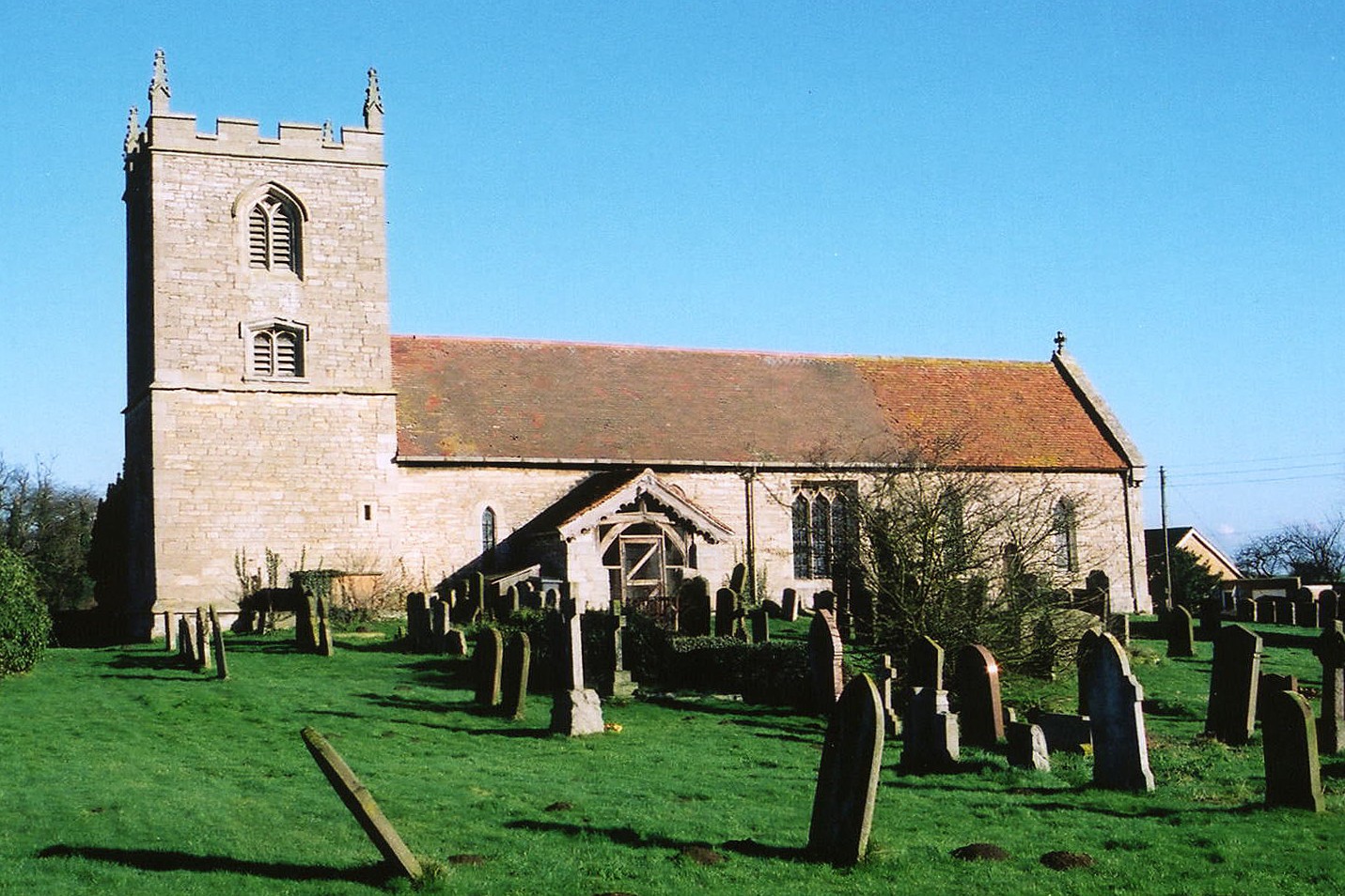
- There were formerly two churches in the parish. Saint Peter's was pulled down around 1637. The church of Saint Denis is of Norman origin.
- St. Denis was restored in 1911-12.
- The church of St. Denis seats 100.
- There is a photograph of the Anglican parish church on the Wendy PARKINSON Church Photos web site.
- Here is a photograph of St. Denis Church, taken by Ron COLE (who retains the copyright):
- The Anglican parish register dates from 1660.
- The Lincolnshire FHS has a Loan Library service which has the parish registers on microfiche for Baptisms from 1661 to 1812 and Marriages from 1661 to 1712.
- The LFHS has published several marriage and burial indexes for the Lafford Deanery to make your search easier.
- Check our Church Records page for county-wide resources.
- The parish was in the Heckington sub-district until 1890 of the Sleaford Registration District.
- In 1891 the parish was reassigned to the Sleaford sub-district of the Sleaford Registration District.
- Check our Civil Registration page for sources and background on Civil Registration which began in July, 1837.
Kirkby la Thorpe is both a village and a parish, just east of Sleaford on the road to Boston. Evedon parish is to the north and Old Sleaford parish to the west. The parish covers about 2,575 acres.
If you are planning a visit:
- The village is bisected by the A17 arterial road as it passes east of Sleaford.
- See our touring page for more sources.
The National Gazetteer of Great Britain and Ireland - 1868
"KIRKBY-LE-THORPE, (or Kirkby-laythorpe), a parish in the wapentake of Aswardhurn, parts of Kesteven, county Lincoln, 2 miles E. of Sleaford, its post town. The village, which is small, is wholly agricultural. The impropriation of Asgarby belongs to Sleaford almshouses. The living is a rectory* with the vicarage and rectory of St. Denys and Asgarby annexed, in the diocese of Lincoln, value £540. The church, dedicated to St. Peter, is an ancient stone structure with a low square tower containing three bells. It has a Norman archway and ancient font richly carved. The parochial charities produce about £2 per annum. There is a National school. The Marquis of Bristol is lord of the manor.
- Ask for a calculation of the distance from Kirkby la Thorpe to another place.
- See our "Maps" page for additional resources.
You can see maps centred on OS grid reference TF098458 (Lat/Lon: 52.998153, -0.364695), Kirkby la Thorpe which are provided by:
- OpenStreetMap
- Google Maps
- StreetMap (Current Ordnance Survey maps)
- Bing (was Multimap)
- Old Maps Online
- National Library of Scotland (Old Ordnance Survey maps)
- Vision of Britain (Click "Historical units & statistics" for administrative areas.)
- English Jurisdictions in 1851 (Unfortunately the LDS have removed the facility to enable us to specify a starting location, you will need to search yourself on their map.)
- Magic (Geographic information) (Click + on map if it doesn't show)
- GeoHack (Links to on-line maps and location specific services.)
- All places within the same township/parish shown on an Openstreetmap map.
- Nearby townships/parishes shown on an Openstreetmap map.
- Nearby places shown on an Openstreetmap map.
- "Kirkby", of course, comes from Old Scandinavian word for "Church".
- The name derives from Ledulve+thore, meaning "settlement of a man named Ledulf".
A. D. Mills, "A Dictionary of English Place-Names," Oxford University Press, 1991. - Locals often pronounce the name with emphasis on the middle word, as in "Kirkby LAY Thorpe".
- This place was an ancient parish in Lincoln county and became a modern Civil Parish when those were established.
- The parish was in the ancient Aswardhurn Wapentake in the North Kesteven division of the county, in the parts of Kesteven.
- In April, 1931, this Civil Parish was reduced in size by 1 acre to create the new Asgarby and Howell Civil Parish.
- For today's district governance, see the North Kesteven District Council.
- Bastardy cases would be heard in the Sleaford petty session hearings every Monday.
- After the 1834 Poor Law Amendment Act reforms, the parish became part of the Sleaford Poor Law Union.
- A National School was built here in 1860.
- For more on researching school records, see our Schools Research page.