
Hide
South Willingham
hide
Hide
hide
Hide
hide
Hide
Hide
hide
Hide
[Transcribed from The National Gazetteer of Great Britain and Ireland 1868]
by Colin Hinson ©2020
Hide
The Mobile Library used to visit by the bus shelter every Tuesday on Route 3. This service has been suspended during the COVID-19 pandemic.
Researchers are encourage to visit the Market Rasen Library on Mill Road, which is normally open 4 days per week.
The Library at Louth will prove useful in your research.
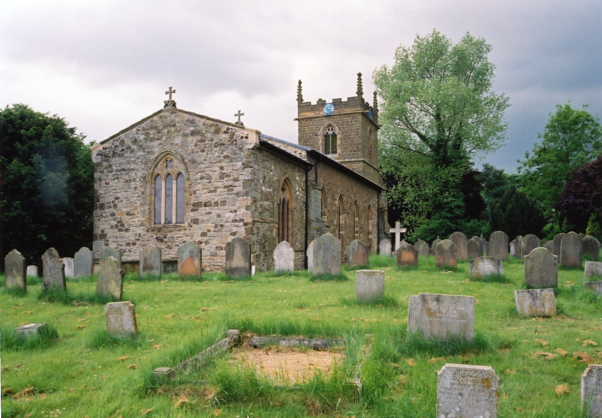
The graveyard surrounds Saint Martin's church on three sides and has over 140 marked graves, the earliest of which is dated 1802.
- The parish was in the Binbrook sub-district of the Louth Registration District.
- Check our Census Resource page for county-wide resources.
- The table below gives census piece numbers, where known:
Census
YearPiece No. 1851 H.O. 107 / 2112 1861 R.G. 9 / 2384 1871 R.G. 10 / 3406 1891 R.G. 12 / 2609
- The Anglican Parish Church is dedicated to Saint Martin.
- The church was originally built in the late 13th century.
- The church was rebuilt in 1835-38.
- The church tower was restored in 1839.
- The church interior was thoroughly renovated in 1885.
- The church seats 160.
- The church is a Grade II listed building with British Heritage.
- Here is a photo of St. Martin's Church, taken by Ron COLE (who retains the copyright):
- The Anglican parish register dates from 1711.
- The LFHS has published several marriage indexes and a burial index for the Westwold Deanery to make your search easier.
- The parish had both a Wesleyan Methodist built in 1834 and a Free Methodist chapel built in 1855, but both have been converted to other uses.
- Check our Church Records page for county-wide resources.
- The parish was in the Binbrook sub-district of the Louth Registration District.
- Check our Civil Registration page for sources and background on Civil Registration which began in July, 1837.
South Willingham is both a village and parish, 8 miles sourth-east of Market Rasen, 10 miles north of Horncastle and situate between Louth and Lincoln. Part of the eastern boundary of the parish follows the course of the River Bain. Hainton parish is just to the north, with Benniworth parish to the south. The parish covers about 2,000 acres.
The village of South Willingham sits just south of the A157 trunk road, on the old road between Hainton and Benniworth. If you are planning a visit:
- By car, take the A157 trunk road between Louth and Wragby, turn south at Hainton.
- The railway station closed to passenger service in November 1951.
- There is regular bus service to the parish. J. HANNON-BRIGGS has a photograph of a Bus Shelter on Geo-graph, taken in January, 2012.
- Check out the Village Website for useful information.
- Stop in at the Village Hall and check the schedule of upcoming events. The photo is by David WRIGHT, taken in June, 2006.
- See our touring page for visitor services.
The National Gazetteer of Great Britain and Ireland - 1868
- Ask for a calculation of the distance from South Willingham to another place.
Bronze Age burial mounds which date from 2400 to 1500 BC are found in the parish.
In 1964 Beaker Pottery dating from about 1150-1400BC was found close to the sand pit at the end of Moors Lane.
Chris ? has a photograph of the Village Hall gift plaque on Geo-graph, taken in April, 2014.
- See our Maps page for additional resources.
You can see maps centred on OS grid reference TF194833 (Lat/Lon: 53.333026, -0.20771), South Willingham which are provided by:
- OpenStreetMap
- Google Maps
- StreetMap (Current Ordnance Survey maps)
- Bing (was Multimap)
- Old Maps Online
- National Library of Scotland (Old Ordnance Survey maps)
- Vision of Britain (Click "Historical units & statistics" for administrative areas.)
- English Jurisdictions in 1851 (Unfortunately the LDS have removed the facility to enable us to specify a starting location, you will need to search yourself on their map.)
- Magic (Geographic information) (Click + on map if it doesn't show)
- GeoHack (Links to on-line maps and location specific services.)
- All places within the same township/parish shown on an Openstreetmap map.
- Nearby townships/parishes shown on an Openstreetmap map.
- Nearby places shown on an Openstreetmap map.
- There are two war memorial plaques and a Roll of Honour on the south wall of the parish church and a plaque in the Village Hall.
- Photographs and notes can be found at South Willingham History site.
- A Royal Observer Corps nuclear monitoring post was installed in the bowl barrow on the High Street, close to the junction with the Donington Road in 1959. Officially known as the Burgh on Bain Post, it was used until 1991.
These are the names from the Roll of Honour in the parish church (errors in the names are noted):
- Anderson, John T. (middle name was Thomas), priv., 2nd Btln. West Riding Regt.
- Crow, Harold (should be David Harold), priv., Yorks & Lancs Regt.
- Grundy, Charles, priv, 6th btln. Lincs Regt.
- Prescott, Frederick, priv., 4th btln. Lincs Regt.
- Prescott, George E (Edward), priv., 10th btln. Essex Regt. (appears on the Stainfield monument, also)
- Rhodes, Edwin (should be Edmund) Gray, priv., 1st btln. Lincs Regt.
- Simons, John C. (middle name should be Edward)
- Tharratt, Thomas H. (Henry), priv., 9th btln. Lincs Regt.
Not commemorated on any known Lincolnshire memorial:
- Edward George Brown, Private 42444. 2nd Battalion, Bedfordshire Regt.
- William Kirk, 6411, Private, 2nd Battalion Duke of Wellington’s
Those who served and returned home:
- Arthur Lloyd Johnson, priv, Lincs Regt.
- This place was an ancient parish in county Lincoln and became a modern Civil Parish when those were established.
/ - The parish was in the ancient Wraggoe Wapentake in the East Lindsey district in the parts of Lindsey.
- You can contact the local Parish Council concerning civic or political issues, but they are NOT staffed nor funded to assist with family history research.
- For today's district governance, see the East Lindsey District Council.
- As a result of the Poor Law Amendment Act reforms of 1834, the parish became part of the Louth Poor Law Union.
- Bastardy cases would be heard in the Wragby petty session hearings.
- A infants school was built here in 1834 to hold up to 30 students. This school closed in 1918 and students transfered to Hainton parish school.
- For more on researching school records, see our Schools Research page.