Hide
Stow in Lindsey
hide
Hide
hide
Hide
hide
Hide
Hide
hide
- Maps
- Migration, Internal◬
- Military History
- Military Records
- Monumental Inscriptions
- Names, Geographical
- Names, Personal◬
- Naturalisation & Citizenship◬
- Newspapers◬
- Occupations◬
- Politics & Government
- Poor Houses, Poor Law
- Population
- Postal & Shipping Guides◬
- Probate Records◬
- Public Records◬
- Schools
- Societies◬
- Voting Registers◬
Hide
"BRANSBY, a township in the parish of Stow, wapentake of Well, and parts of Lindsey, in the county of Lincoln, 7 miles to the N.W. of Lincoln."
"NORMANBY, a hamlet in the parish of Stow, wapentake of Well, parts of Lindsey, county Lincoln, 9 miles N.W. of Lincoln, 7½ S. E. of Gainsborough, and 3 from the Marten railway station."
"STURTON, a township in the parish of Stow, wapentake of Well, parts of Lindsey, county Lincoln, 8 miles N.W. of Lincoln, on Ermine Street."
[Transcribed from The National Gazetteer of Great Britain and Ireland 1868]
by Colin Hinson ©2020
Hide
The Gainsborough Library is an excellent resource with both a Local History section and a Family History section.
Chris MORGAN has a photograph of the Graveyard at Minster Church of St Mary on Geo-graph, taken in July, 2021.
There is a second cemetery, closer to Sturton by Stow. J. THOMAS has a photograph of this cemetery on Geo-graph, taken in June, 2013.
| Stow Road, Sturton by Stow, Cemetery |
| High street, Sturton by Stow, Society of Friends (Quaker) |
- The parish was in the Willingham sub-district of the Gainsborough Registration District.
- In 1891, a district re-organization placed the parish in the Marton sub-district of the Gainsborough Registration District.
- Check our Census Resource page for county-wide resources.
- The table below gives census piece numbers, where known:
| Census Year | Piece No. |
|---|---|
| 1861 | R.G. 9 / 2410 |
| 1871 | R.G. 10 / 3447 |
| 1881 | R.G. 11 / 3297 |
| 1891 | R.G. 12 / 2636 |
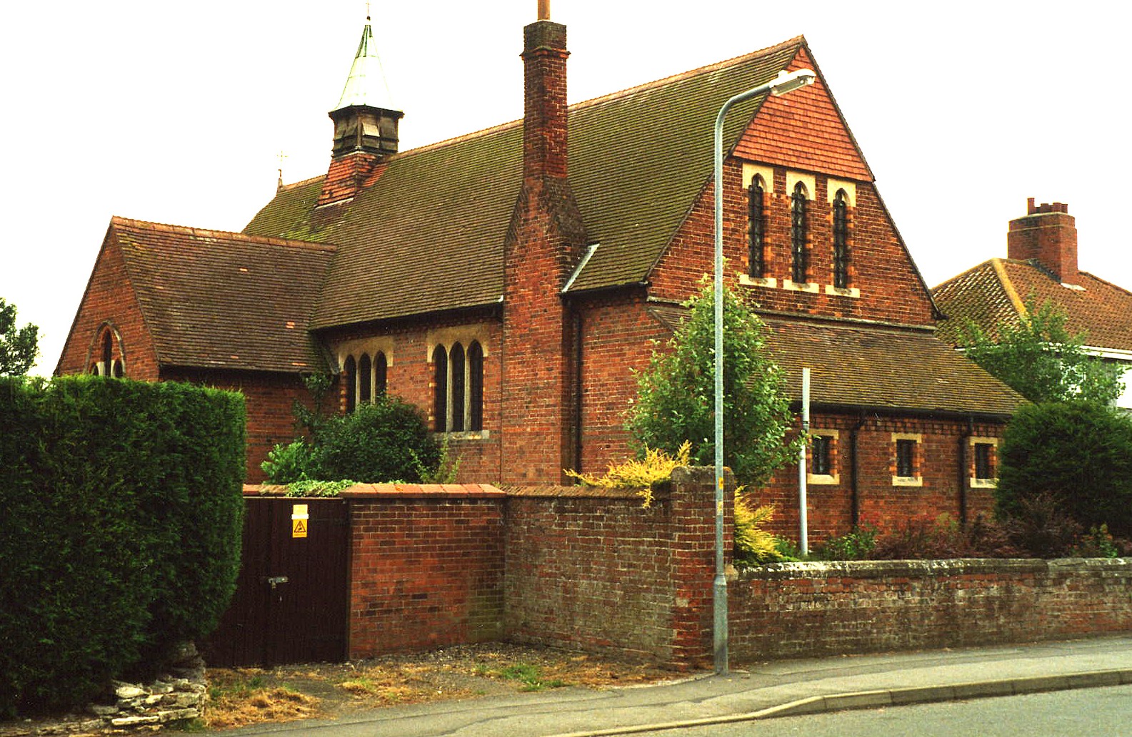
| St Hugh of Avalon, Sturton by Stow, Church of England |
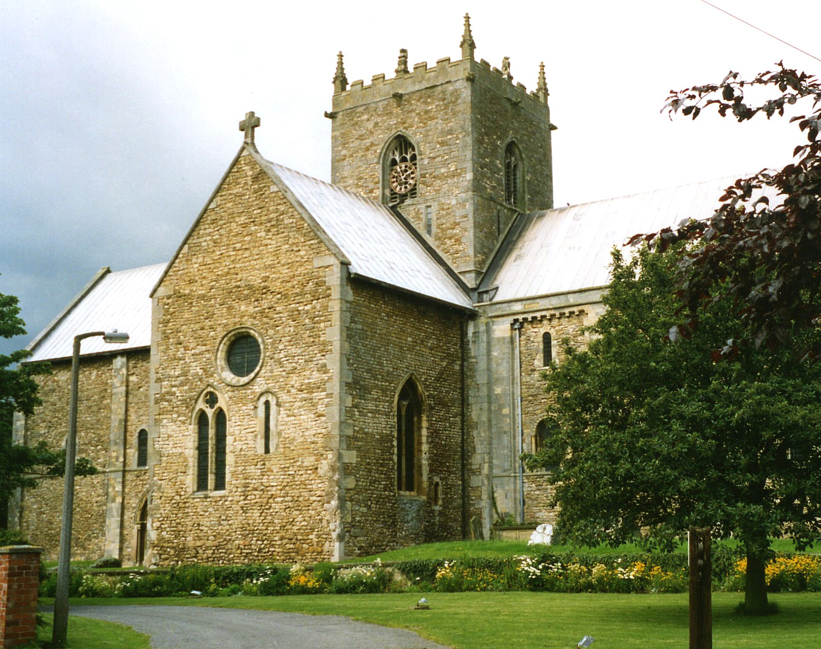
| St Mary, Stow in Lindsey, Church of England |
| Stow Road, Sturton by Stow, Cemetery |
| High street, Sturton by Stow, Society of Friends (Quaker) |
- King Elfrith built a church here in honour of his wife, Saint Elhelreda. It was later enlarged, but was torched by the Danes in the year 870.
- The church remained a ruin until Bishop Eadnoth II founded the Abbey in 1040 and rebuilt the church 10 years later.
- The Church of St Mary originally served as the Cathedral Church of the ancient diocese of Lindsey, founded in the 7th century, and stands on the site of an older one.
- The Church here has been called the "Mother Church of Lincoln" (see History).
- The Abbey was eventually given to the BURGH family as their manor. There are no traces of the Abbey.
- Lady Godiva, wife of Leofric, the Earl of Mercia, founded a nunnery here, but it only lasted for a short period. Alas, the nunnery left no traces, either.
- St. Mary's Church was restored and repaired in 1855 and again in 1863-65.
- The church can seat up to 500.
- There is a photograph of St. Mary's church on the Wendy PARKINSON Church Photos web site.
- Richard CROFT has a photograph of St. Mary's Church on Geo-graph, taken in 2008.
- J. HANNAN-BRIGGS has a photograph of the Altar at St. Mary's Church on Geo-graph, taken in August, 2012.
- Here is a photo of St. Mary's Church, taken by Ron COLE (who retains the copyright):

- St. Hugh's mission chapel in the township of Sturton was attached to St. Mary's Church.
- St. Hugh's was built in 1879.
- St. Hugh's can seat up to 120.
- Here is a photo of St. Hugh's Church, taken by Ron COLE (who retains the copyright):

- The Anglican parish register dates from 1561.
- The Lincolnshire FHS has published several marriage and burial indexes for the Corringham Deanery to make your search easier.
- The church has also been listed, circa 1933, as being in the West Lawres Deanery.
- The Wesleyan Methodist chapel was built in 1824.
- Ian S. has a photograph of the Wesleyan Chapel on Geo-graph, taken in July, 2014.
- For information and assistance in researching this chapel, see our non-conformist religions page.
- Sturton township had a Wesleyan Methodist chapel, a Primitive Methodist chapel and one for Plymouth Brothren.
- Check our Church Records page for county-wide resources.
- The parish was in the Willingham sub-district of the Gainsborough Registration District.
- In 1891, a district re-organization placed the parish in the Marton sub-district of the Gainsborough Registration District.
- Check our Civil Registration page for sources and background on Civil Registration which began in July, 1837.
Stow is both a parish and a village 150 miles north of London and about 6 miles southeast of Gainsborough and 13 miles south of Scunthorpe. The parish itself is bordered on the north by Willingham parish and on the west by Marton parish. The parish consists of four townships: Stow, Normanby, Sturton and Bransby. Sturton is the largest of these townships and is a separate village about a mile south of Stow. The parish covers about 4,000 acres.
Stow village is near the River Till. A tributory of the river passes through the village. The River Till passes near the east end of the parish. The village is also about a mile north of the old Roman Road which is now the A1500 trunk road. If you are planning a visit:
- Take the B1241 trunk road at Lea off of the A156 trunk road south out of Gainsborough and head east about two miles, then follow that road as it turns south for about two more miles.
- "It's a Sign!" Marathon provides a photograph of the Village Sign on Geo-graph, taken in September, 2018.
- Visit our touring page for more sources.
The National Gazetteer of Great Britain and Ireland - 1868
"BRANSBY, a township in the parish of Stow, wapentake of Well, and parts of Lindsey, in the county of Lincoln, 7 miles to the N.W. of Lincoln."
"NORMANBY, a hamlet in the parish of Stow, wapentake of Well, parts of Lindsey, county Lincoln, 9 miles N.W. of Lincoln, 7½ S. E. of Gainsborough, and 3 from the Marten railway station."
"STURTON, a township in the parish of Stow, wapentake of Well, parts of Lindsey, county Lincoln, 8 miles N.W. of Lincoln, on Ermine Street."
- Ask for a calculation of the distance from Stow in Lindsey to another place.
- This place is considered to be the site of the Roman Sidnacaster, which was the seat of the first Saxon bishop of Lincolnshire. A few Roman coins have been found in the parish, as have extensive Roman foundations and lines of streets.
- In 1156, most of Stow was destroyed by fire.
- In 1216, Henry III visited Stow while his army was defeating the French army at Lincoln.
- Stow Fair was held here in early October. It was principally a cattle fair.
- Felons were said to have been executed here in ancient times, at a place called "Gallows Dale".
- For lesser offenses, Richard CROFT has a photograph of the Whipping Post on Geo-graph, taken in August, 2005. The post is dated 1789.
- Graham HOGG has a photograph of the Cross Keys Pub and Restaurant on Geo-graph, taken in March, 2020.
- See our Maps page for additional resources.
You can see maps centred on OS grid reference SK882820 (Lat/Lon: 53.327797, -0.676947), Stow in Lindsey which are provided by:
- OpenStreetMap
- Google Maps
- StreetMap (Current Ordnance Survey maps)
- Bing (was Multimap)
- Old Maps Online
- National Library of Scotland (Old Ordnance Survey maps)
- Vision of Britain (Click "Historical units & statistics" for administrative areas.)
- English Jurisdictions in 1851 (Unfortunately the LDS have removed the facility to enable us to specify a starting location, you will need to search yourself on their map.)
- Magic (Geographic information) (Click + on map if it doesn't show)
- GeoHack (Links to on-line maps and location specific services.)
- All places within the same township/parish shown on an Openstreetmap map.
- Nearby townships/parishes shown on an Openstreetmap map.
- Nearby places shown on an Openstreetmap map.
- The SPENCER family of Bransby hamlet fought in the American Civil War.
See the Roll of Honour webpage for Stow to get a list of the men from the parish who perished in both World Wars.
There is a Memorial Inscription to Richard BURGH who died in 1616 inside Stow Minster Church. It includes his wife Amy.
- "Stow" gives its name to one of the archdeaconries of Lincolnshire.
- "Sturton" was originally called Streeton and was, in recent centuries, called Sturton-in-the-Street from its location on the Roman Road (now known as Tillbridge Lane). After the coming of the railways, it became Sturton by Stow.
- This place was an ancient parish in Lincoln county and became a modern Civil Parish when those were established.
- The parish was in the ancient Well Wapentake (Well Hundred) in the West Lindsey district and in the parts of Lindsey.
- In December, 1866, Sturton township was split off and became it own Sturton by Stow Civil Parish.
- In April, 1936, Coates Civil Parish was abolished and the area amalgamated with Stow Civil Parish.
- Bastardy cases would be heard in the Lincoln petty session hearings.
- By the early 1800's the parish had an Almshouse for four poor people, but the donor was unknown. This Almshouse was abandoned and in disrepair by 1871.
- As a result of the 1834 Poor Law Amendment Act reforms, the parish became part of the Gainsborough Poor Law Union.
- The Parish School was endowed with an annuity by the Countess Dowager of Warwick in 1626.
- A Board School was built in Sturton township in 1878 to hold up to 210 students.
- The children of the parish attended the school in the hamlet of Sturton.
- For more on researching school records, see our Schools Research page.
