
Hide
Upton cum Kexby
hide
Hide
hide
Hide
hide
Hide
Hide
"KEXBY, a township in the parish of Upton, wapentake of Well, parts of Lindsey, county Lincoln, 5 miles S.E. of Gainsborough, its post town, and 3 N. of the Marton railway station. The Methodists and Primitive Methodists have each a chapel. Kexby Bridge House is the principal residence. W. Hutton, Esq., is lord of the manor. On the enclosure of the parish 55 acres of land were awarded to the poor, in lieu of their right of common."
[Transcribed from The National Gazetteer of Great Britain and Ireland 1868]
by Colin Hinson ©2020
Hide
The Gainsborough Library is an excellent resource with both a Local History section and a Family History section.
| All Saints, Upton, Church of England |
- The parish was in the Willingham sub-district of the Gainsborough Registration District until 1891.
- After an 1891 redistricting, the parish was in the Marton subdistrict of the Gainsborough Registration District.
- Check our Census Resource page for county-wide resources.
- The table below gives the Census Piece Numbers for the parish, where known.
| Census Year | Piece No. |
|---|---|
| 1841 | H.O. 107 / 647 |
| 1861 | R.G. 9 / 2410 |
| 1871 | R.G. 10 / 3447 |
| 1891 | R.G. 12 / 2636 |
| 1901 | R.G. 13 / 3116 |
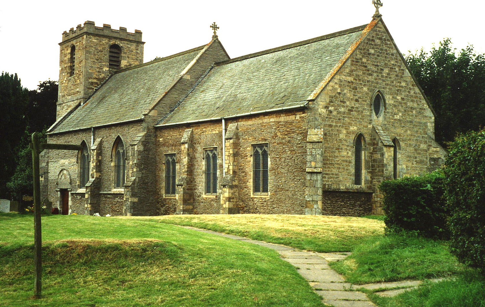
- The Anglican parish church is built of stone and is dedicated to All Saints.
- Many parts of the church, which sits on a mound, are of Norman origin.
- In the late 18th century, the tower was rebuilt.
- The church seats about 180 people.
- There is a photograph of All Saints church on the Wendy PARKINSON web site under "Yet More Lincolnshire".
- Here is a photo of All Saints Church, taken by Ron COLE (who retains the copyright):
- The parish register, which includes Kexby, dates back to 1563.
- The Lincolnshire FHS has published several marriage and burial indexes for the Corringham Deanery to make your search easier.
- The Wesleyans Methodists had a chapel here in the early 1900s. Kexby village had a Wesleyan chapel built in 1857 and a Primitive Methodist chapel.
- For more information on records available for these chapels, please see our Nonconformist Chapels page.
- Check our Church Records page for county-wide resources.
- The parish was in the Willingham sub-district of the Gainsborough Registration District until 1891.
- After an 1891 redistricting, the parish was in the Marton subdistrict of the Gainsborough Registration District.
- Check our Civil Registration page for sources and background on Civil Registration which began in July, 1837.
Upton is both a parish and a village about 149 miles north of London. It is 4 miles south-east of Gainsborough and 10 miles south of Scunthorpe. The parish itself is bordered on the north by Springthorpe and Heapham parishes, on the east by Glentworth parish, to the south by Willingham by Stow parish.
The River Till passes near the north end of Upton village. Kexby is a village in the same parish, due south of Upton. If you are planning a visit:
- Take the B1247 at Lea off of the A156 trunk road south out of Gainsborough and head east about two miles. That should take you to Kexby. You can then turn north for Upton about a half mile away.
- Visit our touring page for more sources.
The National Gazetteer of Great Britain and Ireland - 1868
"KEXBY, a township in the parish of Upton, wapentake of Well, parts of Lindsey, county Lincoln, 5 miles S.E. of Gainsborough, its post town, and 3 N. of the Marton railway station. The Methodists and Primitive Methodists have each a chapel. Kexby Bridge House is the principal residence. W. Hutton, Esq., is lord of the manor. On the enclosure of the parish 55 acres of land were awarded to the poor, in lieu of their right of common."
- Ask for a calculation of the distance from Upton cum Kexby to another place.
- See our Maps page for additional resources.
You can see maps centred on OS grid reference SK869868 (Lat/Lon: 53.371232, -0.695636), Upton cum Kexby which are provided by:
- OpenStreetMap
- Google Maps
- StreetMap (Current Ordnance Survey maps)
- Bing (was Multimap)
- Old Maps Online
- National Library of Scotland (Old Ordnance Survey maps)
- Vision of Britain (Click "Historical units & statistics" for administrative areas.)
- English Jurisdictions in 1851 (Unfortunately the LDS have removed the facility to enable us to specify a starting location, you will need to search yourself on their map.)
- Magic (Geographic information) (Click + on map if it doesn't show)
- GeoHack (Links to on-line maps and location specific services.)
- All places within the same township/parish shown on an Openstreetmap map.
- Nearby townships/parishes shown on an Openstreetmap map.
- Nearby places shown on an Openstreetmap map.
- This place was an ancient parish in Lincoln county and became a modern Civil Parish when those were established.
- The parish was in the ancient Well Wapentake (Well Hundred) in the West Lindsey district and parts of Lindsey.
- The parish was also in the ancient Soke of Kirton.
- Today's district governance is provided by the West Lindsey District Council.
- Bastardy cases would be heard at the Gainsborough petty session hearings.
- Two 17th-century benefactors left two acres of land to the highest bidder each year. The rent was given to the poor.
- The Common Lands were enclosed here in 1788.
- As a result of the 1834 Poor Law Amendment Act, the parish became part of the Gainsborough Poor Law Union .
- A Public Elementary School was built in 1853 in Kexby. This was enlarged in 1895.
- For more on researching school records, see our Schools Research page.