
Hide
Wellingore
hide
Hide
hide
Hide
hide
Hide
Hide
[Transcribed from The National Gazetteer of Great Britain and Ireland 1868]
by Colin Hinson ©2020
Hide
- The parish was in the Leadenham sub-district of the Sleaford Registration District.
- Check our Census Resource page for county-wide resources.
- The table below gives census piece numbers, where known:
| Census Year | Piece No. |
|---|---|
| 1841 | H.O. 107 / 624 |
| 1851 | H.O. 107 / 2101 |
| 1861 | R.G. 9 / 2344 |
| 1871 | R.G. 10 / 3351 |
| 1891 | R.G. 12 / 2580 |
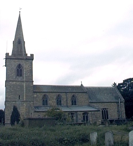
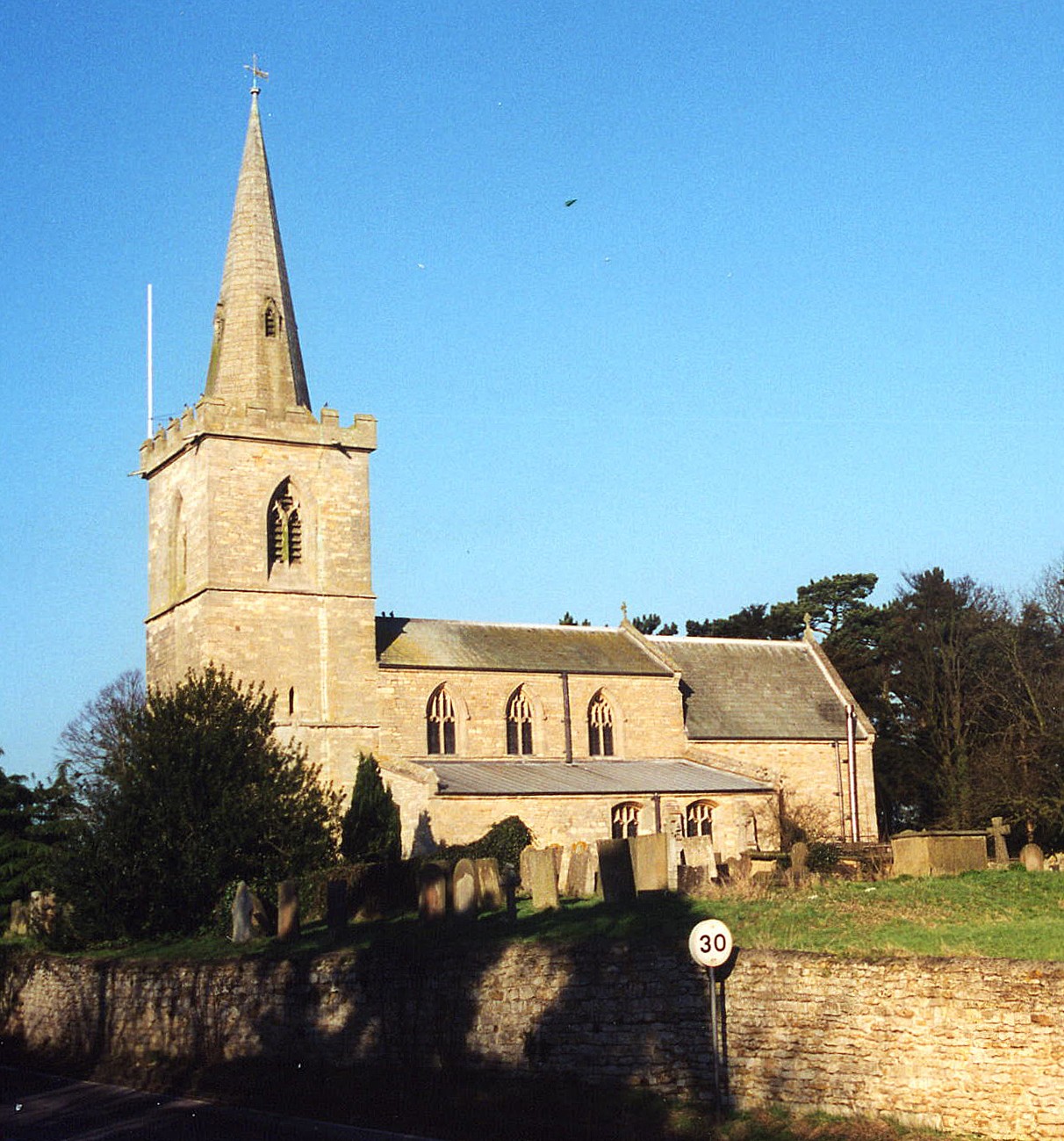
- The Anglican church is dedicated to All Saints.
- The church was built in the 13th century. It includes some inscriptions from 1613 and 1787 and memorials dated 1575 (to Charles WYNGFIELD) and 1637.
- The church was restored in 1878.
- The church seats 209.
- Here is a photo of All Saints church, taken by (and copyright of) Wendy PARKINSON.
- Here is a photo of All Saints Church, taken by Ron COLE (who retains the copyright):
- The parish register dates from 1653 and mentions the Great Fire of London in 1666 and the "extirpation" that same year of Boothby church by a hurricane.
- The I.G.I. contains entries from 1602 - 1868.
- Churchwarden accounts date from 1660.
- Parish registers are on file at the Society of Genealogists, covering 1602 - 1837.
- We also have the beginnings of a parish register extract in a text file you can view.
- Boyd's Marriage Index holds parish marriages from 1651 to 1750. Pallot's Marriage Index covers 1790 - 1837.
- The LFHS has published several marriage indexes for the Graffoe Deanery to make your search easier.
- The Wesleyan Methodists also had a small chapel here, which they replaced with a larger facility in 1887. The Reform Methodists also held services in the parish in the mid 19th century. For information and assistance in researching these chapels, see our non-conformist religions page.
- David BEVIS has a photograph of the Wesleyan Chapel in High Street on Geo-graph, taken in July, 2012.
- Check our Church Records page for county-wide resources.
- The parish was in the Leadenham sub-district of the Sleaford Registration District.
- Check our Civil Registration page for sources and background on Civil Registration which began in July, 1837.
Wellingore is both a village and a parish 10 miles south of Lincoln and 10 miles north-west of Sleaford. Welbourn parish lies to the south and Temple Bruer to the east. The parish covers about 3,200 acres.
The village of Wellingore sits on the Cliff range of hills overlooking the valley of the River Brant to the west. It was once a large village and pleasant stop for coach travelers between Grantham and Lincoln. If you are planning a visit:
- Take the A607 trunk road, which passes through the village, north out of Grantham or south out of Lincoln. The A15 trunk road also passes about a mile east of the village.
- Pick up a copy of the booklet "Days Out in the Heart of Lincolnshire; Stepping Out - Walks (Wellingore and Temple Bruer); North Kesteven Airfield Trail" - available from: Northern Kesteven District Council, Sleaford Tourist Information Centre, Moneys Yard, Sleaford, Lincolnshire NG34 7TW. Tel: 01529 414294.
- Visit our touring page for more sources.
The National Gazetteer of Great Britain and Ireland - 1868
- Ask for a calculation of the distance from Wellingore to another place.
- In the center of the village there once stood an ancient cross, erected in the 14th century.
- In the 19th century, the village was served by the Navenby station, one and half miles north of Wellingore, on the Great Northern Railway.
- Richard CROFT has a photograph of The Marquis of Granby in the heart of the village on Geo-graph, taken in June, 2012.
- In 1871, the principal landowner was Geoffery H. NEVILLE. Large holdings were also held by the Dean and Chapter of Lincoln (474 acres) and Dr. J. D. CAMPBELL.
- Wellingore Hall was a large stone mansion, residence of Geoffery Henry NEVILE in 1871, originally built in 1750. Attached to it was a Catholic domestic chapel dedicated to St. Augustine, erected around 1882. The chapel burnt down in 1884 and was rebuilt the following year.
- Wellingore Hall was requisitioned during World War II and used as a mess for the RAF crews and as an interrogation centre for the prisoners of war.
- Richard CROFT has a photograph of Wellingore Hall on Geo-graph, taken in December, 2007.
- Hill House was the seat of Matthew ASHTON in 1842.
- See our Maps page for additional resources.
You can see maps centred on OS grid reference SK984567 (Lat/Lon: 53.098714, -0.532408), Wellingore which are provided by:
- OpenStreetMap
- Google Maps
- StreetMap (Current Ordnance Survey maps)
- Bing (was Multimap)
- Old Maps Online
- National Library of Scotland (Old Ordnance Survey maps)
- Vision of Britain (Click "Historical units & statistics" for administrative areas.)
- English Jurisdictions in 1851 (Unfortunately the LDS have removed the facility to enable us to specify a starting location, you will need to search yourself on their map.)
- Magic (Geographic information) (Click + on map if it doesn't show)
- GeoHack (Links to on-line maps and location specific services.)
- All places within the same township/parish shown on an Openstreetmap map.
- Nearby townships/parishes shown on an Openstreetmap map.
- Nearby places shown on an Openstreetmap map.
- The Royal Naval Air Service (RNAS) opened an airfield here in 1917 designated as "Wellingore Heath".
- It appears there were no World War I flight operations out of "Wellingore Heath," but there were a number of forced landings there.
- It isn't clear when the RNAS stopped using the field, but it was probably right after the Great War ended.
- As the Royal Air Force was preparing for the start of World War II, it re-opened "Wellingore Heath" in 1935.
- "RAF Wellingore Heath" was upgraded to a full airfield during the winter of 1939/40.
- The airfield closed immediately after the war in Europe in 1945, but the station was used as a prisoner of war camp for a brief period.
- The land was finally returned to the OVERTON family in the 1950s.
- Light civilian aircraft still use a grass strip in the area at Griffin's Farm.
- RAF Wellingore on wikipedia
- There is a photograph of the War Memorial on Flickr (Under Description and Travel)
For a photograph of the Wellingore War Memorial and the names on it, see the Roll of Honour site.
- The origin of the name Wellingore is uncertain, but is probably Old English wella+inga+ofer, for "promontory of the dwellers by a spring or stream". It appeared in the 1086 Domesday Book as Wellingoure. In some ancient records the name is rendered as Willingore.
[A. D. Mills, "A Dictionary of English Place-Names," Oxford University Press, 1991]
>
- This place was an ancient parish in Lincoln county and became a modern Civil Parish when those were established.
- The parish was in the High division of the ancient Boothby Graffoe Wapentake in the North Kesteven division of the county, in the parts of Kesteven.
- You can contact the local Parish Council concerning civic or political issues, but they are NOT staffed to assist you with family history searches.
- For today's district governance, see the North Kesteven District Council.
- Bastardy cases would be heard in the Sleaford petty session hearings every Monday.
- Edmund ELLIS left a yearly rent-charge of £4, out of land at Fulbeck, to the poor in 1654.
- Two other donors, James BRAND and Robert STEPHENSON, left the interest on £20 for the poor in 1719 and 1729.
- As a result of the 1834 Poor Law Amendment Act, the parish became part of the Sleaford Poor Law Union.
- A school was built here around 1836 and in 1871 had 40 students. In 1913, the Public Elementary School had about 77 children attending.
- For more on researching school records, see our Schools Research page.
We have a list, provided by Mark, in Barcelona of Wellingore freeholders 1723, Freeholders who took part in an election for a knight of the Shire of Lincoln on 12th February 1723.