
Hide
Wilsford
hide
Hide
hide
Hide
hide
Hide
Hide
hide
Hide
"WILSFORD, a parish in the wapentake of Winnibriggs, parts of Kesteven, county Lincoln, 4½ miles S.W. of Sleaford, and 9 N.E. of Grantham. It is situated on the banks of a rivulet near the ancient Ermine Street. The parish includes part of the village of Ancaster, and the hamlet of Hanbeck. In the reign of Stephen, Hugo de Wake founded a priory here as a cell to the Abbey of Bec in Normandy, which on the suppression of alien priories was given to Bourn Abbey, and at the Dissolution came to Charles Duke of Suffolk. A freestone, known as Ancaster stone, is extensively quarried on the heath, which was inclosed in 1775. The living is a rectory in the diocese of Lincoln, value £600. The church is dedicated to St. Mary. The register commences in 1479. The Primitive Methodists have a chapel."
"HANBECK, a hamlet in the parish of Wilsford, county Lincoln, 5 miles N.E. of Grantham."
[Transcribed from The National Gazetteer of Great Britain and Ireland 1868]
by Colin Hinson ©2020
Hide
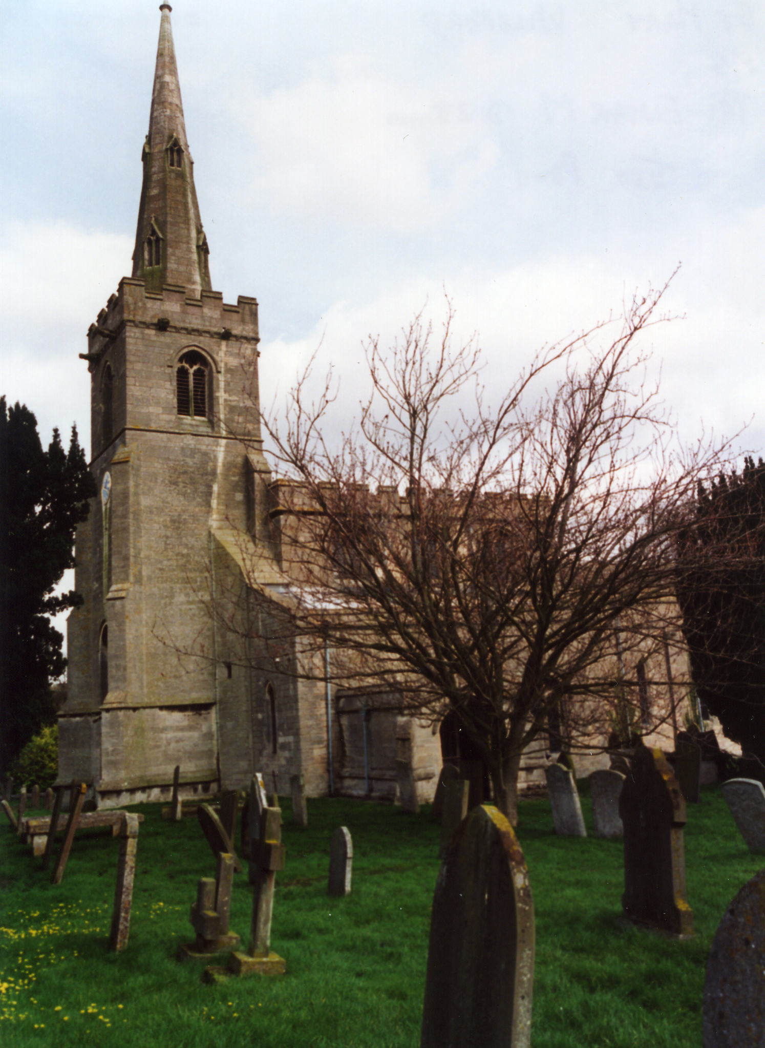
| St Mary, Wilsford, Church of England |
- The parish was in the Leadenham sub-district of the Sleaford Registration District.
- Check our Census Resource page for county-wide resources.
- The table below gives census piece numbers, where known:
| Census Year | Piece No. |
|---|---|
| 1841 | H.O. 107 / 624 |
| 1861 | R.G. 9 / 2344 |
| 1871 | R.G. 10 / 3351 |
| 1891 | R.G. 12 / 2580 |
| St Mary, Wilsford, Church of England |
- The village is the site and seat of an ancient priory founded in the reign of King Stephen by Hugh le Wake and affiliated with the abbey of Bec in Normandy. The cell was later given to Bourne Abbey. At the dissolution of the monasteries, the land went to Charles, Duke of Suffolk. All traces of the buildings are now gone.
- The Anglican church is dedicated to Saint Mary and was built in the Norman period, although apparent traces of Saxon work are evident in the chapel.
- The church was restored in 1860-61 and again in 1871.
- The church seats 226.
- Burials in the churchyard ceased in the 1920s. A new cemetery was opened on School Lane at that time.
- A photograph of Saint Mary's church is at the Wendy Parkinson English Church Photographs site.
- Here is a photo of St. Mary's Church, taken by Ron Cole (who retains the copyright):
- The Anglican parish register dates from 1668; marriages from 1754. The Bishop's transcripts go back to 1562.
- Parish registers are on file at the Society of Genealogists, covering baptisms from 1562 to 1774 and marriages from 1700 to 1753.
- The church is part of the Ancaster/Wilsford group of the Loveden Deanery. The LFHS has published several marriage indexes for the Loveden Deanery to make your search easier.
- The Lincolnshire FHS has a Loan Library service which has the parish registers on microfiche for baptisms and marriages from 1668 to 1812.
- The Primitive Methodists had a chapel here, erected in 1859 and rebuilt in 1899. For information and assistance in researching these chapels, see our non-conformist religions page.
- Check our Church Records page for county-wide resources.
- The parish was in the Leadenham sub-district of the Sleaford Registration District.
- Check our Civil Registration page for sources and background on Civil Registration which began in July, 1837.
Wilsford is both a village and a parish five miles WSW of Sleaford and nine miles northeast of Grantham. Ancaster parish lies to the north and west and Rauceby parish to the north and east. The parish covers about 3,000 acres and includes the eastern edge of the village of Ancaster. The ancient hamlet of Hanbeck is part of the parish, now only a farm.
The village of Wilsford sits on the south bank of a rivulet that eventually joins the River Slea. If you are planning a visit:
- Take the A153 trunk road west out of Sleaford or take Ermine Street (B6403) north past Grantham and turn right at Ancaster.
- The Lincolnshire Trust maintains two Protected Roadside Verges in Wilsford: Duke's Covert and Copper Hill. Duke's Covert lies in the triangle of land at Copper Hill between Ermine Street and the road to Heydour, about 1 km (0.6 miles) to the south of Ancaster. The roadside verges at Copper Hill are protected under the scheme operated by the Trust and Lincolnshire County Council (PRV 024). They have a particularly rich limestone flora with much rock-rose, horseshoe and kidney vetches, spiny restharrow, purple milk-vetch and fairy flax. Butterflies include brimstone and common blue. This was the last known Lincolnshire locality for the chalkhill blue butterfly, and is the most northerly point for man orchid in Britain.
- Visit the Plough Inn on Main Street, Wilsford, Grantham, LIN NG32 3NS, telephone: 01400 230304.
- Visit our touring page for more sources.
The National Gazetteer of Great Britain and Ireland - 1868
"HANBECK, a hamlet in the parish of Wilsford, county Lincoln, 5 miles N.E. of Grantham."
- Ask for a calculation of the distance from Wilsford to another place.
- After the Norman Conquest, Bishop Remigius purchased the manor of Wilsford from Godfrey de Cambrai.
- Sir Charles COTTEREL, master of the ceremonies to Charles II in 1641, was born here.
- The Wilsford Quarries, in the southwest corner of the parish, were the source of some beautiful white freestone known as "Ancaster Stone."
- In 1871, the principal landowners were the Marquis of Bristol and the CALCRAFT, PARKINSON, WILLSON and ALLIX families.
- In 1913, the principal landowners were Mrs. MYERS of Dunningwell, Cumberland; W. R. MEDWELL; the Rev. Vere Francis WILLSON; Mrs. LUCAS-CALCRAFT and George Herbert PEAKE.
- Wilsford Hall, built of stone in 1649 and enlarged in 1776, is a large ancient mansion in the Elizabethan style, formerly owned by the Duke of Rutland. In 1815 it was purchased by James Henry PARKINSON and became his residence. In 1913 it was no longer occupied.
- See our Maps page for additional resources.
You can see maps centred on OS grid reference TF005431 (Lat/Lon: 52.975522, -0.504856), Wilsford which are provided by:
- OpenStreetMap
- Google Maps
- StreetMap (Current Ordnance Survey maps)
- Bing (was Multimap)
- Old Maps Online
- National Library of Scotland (Old Ordnance Survey maps)
- Vision of Britain (Click "Historical units & statistics" for administrative areas.)
- English Jurisdictions in 1851 (Unfortunately the LDS have removed the facility to enable us to specify a starting location, you will need to search yourself on their map.)
- Magic (Geographic information) (Click + on map if it doesn't show)
- GeoHack (Links to on-line maps and location specific services.)
- All places within the same township/parish shown on an Openstreetmap map.
- Nearby townships/parishes shown on an Openstreetmap map.
- Nearby places shown on an Openstreetmap map.
- The War Memorial is a stained glass window in Saint Mary's Church, dedicated in 1920.
For a photograph of the Wilsford War Memorial and the names on the Roll of Honour, see the Roll of Honour site.
- Anciently called Wivelsford, the name is Old English wifel's+ford, for "ford of a man named Wifel". It appeared in the 1086 Domesday Book as Wivelesforde.
[A. D. Mills, "A Dictionary of English Place-Names," Oxford University Press, 1991]
- There is evidence that prior to the Conquest this was a Saxon meeting place.
- This place was an ancient parish in county Lincoln and became a modern Civil Parish when those were established.
- The parish was in the ancient Flaxwell Wapentake in the North Kesteven division of the county, in the parts of Kesteven.
- Kelly's 1900 Directory of Lincolnshire reports that the parish was reassigned to the ancient Winnebriggs and Threo wapentake.
- In April, 1931, the parish was reduced in size by giving 403 acres of land to Ancaster CIvil Parish.
- For today's governance, see the North Kesteven District Council.
- The parish heath was enclosed in 1775, but there appears to be no record of any specific aid to the poor.
- After the Poor Law Amendment Act reforms of 1834, the parish became part of the Sleaford Poor Law Union in September of 1836.
- Bastardy cases would be heard in the Sleaford petty session hearings every Monday.
- A Public Elementary School was built here in 1857 by Miss CHENEY, the late lady of the manor, on a site granted by the Rev. J. P. B. YOUNGE. A classroom for infants was added in 1877 and another in 1897.
- For more on researching school records, see our Schools Research page.