
Hide
St Martin Ludgate
hide
Hide
hide
Hide
Hide
Hide
"ST. MARTIN LUDGATE, the church of, is situated on the north side of Ludgate-street, between Stationers'-hall-oourt and the Old Bailey. It is so named from being dedicated to the before-mentioned St. Martin, and its contiguity to the ancient Ludgate. The patronage of this church was originally in the abbot and convent of Westminster, and continued with them till the suppression of that monastery by Henry VIII., who erected Westminster into a Bishoprick and conferred it on the new bishop. That see, however, being dissolved by Edward VI., Queen Mary his successor granted the advowson to the Bishop of London and his successors, in whom it still remains. The ancient church was destroyed by the great fire in 1666, after which the present church was erected, from the designs of Sir Christopher Wren. It is a rectory in the city, diocese and archdeaconry of London, and in the patronage of the Bishop of London. The present rector is the Rev. J. B. Bingham, Vicar of Great Gaddesden, who was instituted in 1819." [James Elmes. A Topographical Dictionary of London and its Environs (1831) - transcribed by Brian Randell]
Hide
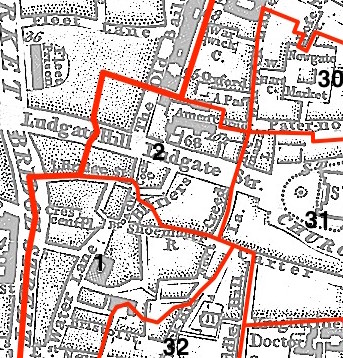
This parish - no. 2 in the above map - is located in Farringdon Within Ward.
The church dates from before the Great Fire, and was rebuilt by Wren 1677-87.
Hide
London Metropolitan Archive holdings for St Martin Ludgate.
Malcolm, James Peller. St Martin Ludgate. In Londinium Redivivum Or an Antient History and Modern Description of London. Nichols and Son (1807) Vol. 4 pp.355-376. [Full text]
Online Parish Register Images and Indexes for St Martin Ludgate parish are provided by, or at various subscription sites via, the LDS FamilySearch wiki.
No non-Church of England denominations have been identified for St Martin Ludgate [LDS FamilySearch Wiki].
Wikipedia page on St Martin Ludgate.
- Ask for a calculation of the distance from St Martin Ludgate to another place.
Summary history of St Martin Ludgate parish, from the Worshipful Company of Parish Clerks.
Public Houses, Inns & Taverns of the parish of St Martin Ludgate - provides "information from census records, trade directories, etc."
You can see maps centred on OS grid reference TQ318812 (Lat/Lon: 51.514037, -0.102095), St Martin Ludgate which are provided by:
- OpenStreetMap
- Google Maps
- StreetMap (Current Ordnance Survey maps)
- Bing (was Multimap)
- Old Maps Online
- National Library of Scotland (Old Ordnance Survey maps)
- Vision of Britain (Click "Historical units & statistics" for administrative areas.)
- English Jurisdictions in 1851 (Unfortunately the LDS have removed the facility to enable us to specify a starting location, you will need to search yourself on their map.)
- Magic (Geographic information) (Click + on map if it doesn't show)
- GeoHack (Links to on-line maps and location specific services.)
- All places within the same township/parish shown on an Openstreetmap map.
- Nearby townships/parishes shown on an Openstreetmap map.
- Nearby places shown on an Openstreetmap map.
Surnames from the 1881 census in the St Martin Ludgate and St Martin Ludgate London districts.
Clerical career summaries for the parish of St Martin Ludgate, from the Clergy of the Church of England Database website.
Sources for listings of taxpayer names for St Martin Ludgate parish, listed on the LDS FamilySearch wiki.