Hide
Brougham
hide
Hide
hide
Hide

Hide
Hide
"BROUGHAM, a parish in WEST ward, county of WESTMORLAND, If mile (S. E.) from Penrith, cpntaining 143 inhabitants. The living is a rectory, in-the archdeaconry and diocese of Carlisle, rated in the king's books at £ 16. 10. 7., and in the patronage of the Earl of Thanet. The church, dedicated to St. Ninian; and hence vulgarly called the Ninekirks, stands pleasantly within a curve on the southern bank of the riverEamont. There is also a chapel of ease, supposed to be dedicated to St. Wilfrid, in the western part of the parish, which, together with the church, was rebuilt in 1659, by Anne, the celebrated Countess of Pembroke. . .. This parish is bounded on every side, except the south, by the rivers Eden, Eamont, and Lowther, which unite here: there are two stone bridges across the Eamont (one of them built in 1814, to afford a shorter line of communication between Penrith and Appleby), and one over the Lowther: the village of Brougham has long since disappeared."
[From Samuel Lewis A Topographical Dictionary of England (1831) - copyright Mel Lockie 2016]
Hide
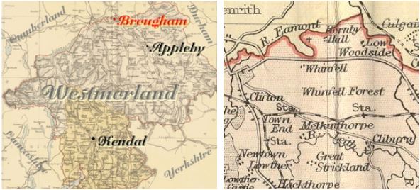
Brougham is a parish in the North of the county adjacent to Cliburn, Temple Sowerby, Clifton and Cumberland. It includes the townships of Moorhouses and Woodside, and also ... Whinfell Park... Hornby... Winderwath...
Hide
M.I.s for Brougham were transcribed in Monumental Inscriptions of Westmorland by E. Bellasis 1888-89 and are available on Westmorland Papers.
Returns survive only for Moorhouses and Woodside in the 'census' of 1787 and are held at the Kendal Record Office of Cumbria Archives Service. The Record Office reference is WQ/SP/C. They are transcribed in Vital Statistics published by Curwen Archives Trust 1992. ISBN 1897590008. The trancription is on EdenLinks.
Census returns are available from the usual sources for 1841-1911.
Transcript and index for 1851 has been published by the Cumbria Family History Society and also in 'North Westmorland - An Index to the 1851 Census' compiled by David Lowis and Barbara Slack.
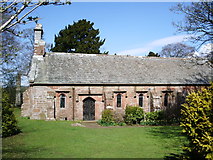
 | St Wilfred Rebuilt by Lady Anne Clifford in 1658. Remodelled inside in 1840s. Historical and architectural notes on National Heritage List (English Heritage site). This and other photographs on the Geograph site Photograph(s) and description on VisitCumbria. |
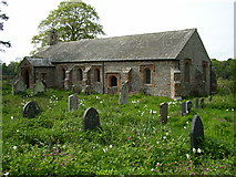
| St Ninian. Ninekirks. Historical and architectural notes on National Heritage List (English Heritage site). History and description on Wikipedia. This and other photographs on the Geograph site Photograph(s) and description on VisitCumbria |
Parish Registers and Bishop's Transcripts are held by Cumbria Archives :
originals at Kendal RO and microfilm copies at Carlisle RO.
| Baptism registers | 1681-1979 |
| Marriage registers | 1681-1972 |
| Banns registers | 1772-1959 |
| Burial registers | 1681-1812 |
| Bishops transcripts | 1645-1898 |
See the CASCAT online calogue for WPR46 for information on these and other parish records..
For searching on LDS familysearch.org see IGI batch numbers (compiled by Jake Prescott)
or use the batch number search site (by Hugh Wallis).
Nicolson and Burn: The history and antiquities of the counties of Westmorland and Cumberland. 1777. Transcribed by Anne Nichols.
"Brougham, Burg-ham (or Castle-town), was the Brovacum of the Romans, where they had a company of Defensores; and many Roman antiquities have been found here. The parish of Brougham is bounded on the east by the parish of Kirkby Thore; on the south, by the parishes of Clibburn and Clifton; on the west, by the parishes of Barton and Penrith; and on the north, by the parish of Edenhall. It is a rectory. The church of Brougham stands in a beautiful situation, nigh the river Eamont, at a great distance from any inhabitants. . . The church is vulgarly called Ninekirks, supposed to have been dedicated to St. Ninian, a Scottish saint, to which kingdom probably this church did belong at the time of the dedication: It is sometimes called the church of St. Wilfrid. . . So we must either suppose that the Scots had one tutelar saint of the church, and the English another; or rather perhaps that this latter is the saint of the chapel, which is not so properly a chapel of ease under the mother church, as another church (as it were) within the same parish. . ."
The University of Leicester History, Directory & Gazetteer of Cumberland & Westmorland, 1829
- Ask for a calculation of the distance from Brougham to another place.
The Later Records relating to North Westmorland by John F. Curwen (1932) on British History Online Cumbria County History Trust has published a "Jubilee Digest" for the township of Brougham.
Magna Britannica 1731 (Transcribed by Sarah Reveley and Westmorland Rootsweb list):
"Brougham, the Lordship and Castle of the Viponts, included in the Barony of Appleby and Burgh, given Robert de Vipont by King John, Reg. 4. from whose Family, after a few Descents, it passed by the Heir general to the noble Family of Cliffords, who enjoyed them uninterruptedly divers Successions; for though we find them with other Estates in the Hands of GuyBeauchamp, Earl of Warwick, and others, 7 Edw. II. Yet they held them not in their own Right, but as Guardians to Roger de Clifford, who was then in his Minority, and had them all restored to him, when he became of Age. He was succeeded in his Honour and Estate by Robert his Brother, who being possessed of this Castle of Brougham, entertained Robert de Baliol, King ofScotland, when he came a Hunting in the Woods and Chases of this Robert. How this Manor came to be alienated from the Cliffords, we do not find, but that it was so, appears from hence; That the Lady Anne Clifford, when she endowed her noble Alms-house at Appleby, purchased this Manor to settle upon it. This Place stands upon the Roman military Way, called the Maiden-Way, just upon the Confines of Cumberland, and is thought to have been the old Broconiacum (written in other Copies Brownacis, and Brocovum, and in theNotitia, Broconiacum) mentioned in Antoninus's Itinerary, which is renderedalmost certain, not only by its Distance from Vertere, Burgh, but from theseveral Roman Coins, Altars, and other Antiquities, which have at Times been found here. The company of the Desensores had their Abode here, as theNotitia expressly tells us, but Age has consumed the Castle and other Roman Buildings, which might have confirmed what we have said, so that only the Place hath the Name of Brovoniacum, ie. Brougham stamp'd upon it, being almost the same. Burgham Castle, with the Wood of Quinsell, and and a third Part of the Manor of the Town, the Possessions of Roger Lord Clifford 4th, of which he died seized with many other Estates 13 Rich. II. Leaving them to Thomas his Son and Heir. He had Summons to Parliament from 31 Edw. III. To the 12Rich. II. The name is probably derived from O.N. borg and O.E. burh castle or fort."
You can see maps centred on OS grid reference NY567282 (Lat/Lon: 54.646977, -2.671802), Brougham which are provided by:
- OpenStreetMap
- Google Maps
- StreetMap (Current Ordnance Survey maps)
- Bing (was Multimap)
- Old Maps Online
- National Library of Scotland (Old Ordnance Survey maps)
- Vision of Britain (Click "Historical units & statistics" for administrative areas.)
- English Jurisdictions in 1851 (Unfortunately the LDS have removed the facility to enable us to specify a starting location, you will need to search yourself on their map.)
- Magic (Geographic information) (Click + on map if it doesn't show)
- GeoHack (Links to on-line maps and location specific services.)
- All places within the same township/parish shown on an Openstreetmap map.
- Nearby townships/parishes shown on an Openstreetmap map.
- Nearby places shown on an Openstreetmap map.
Brougham is in the diocese of Carlisle and wills will be in Carlisle Record Office.
Hearth Tax records for 1674 Brougham transcribed on Edenlinks.
Hearth Tax records for 1674 Whinfield & Woodside (Brougham) transcribed on Edenlinks.
Hearth Tax records for 1674 Whinfield transcribed on Edenlinks.
Window Tax records for 1777 Brougham transcribed on Edenlinks.

