Hide
Grasmere
hide
Hide
hide
Hide

Hide
Hide
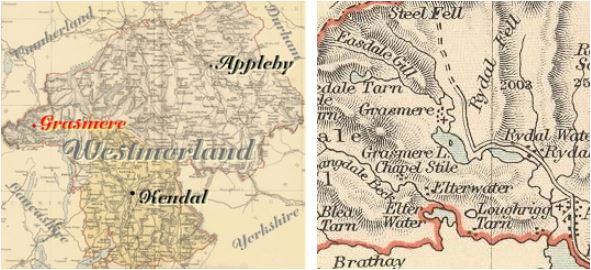
"GRASMERE, a parish in KENDAL ward, county of WESTMORLAND, comprising the chapelries of Ambleside and Langdales, and the townships of Grasmere and Rydal with Loughbrigg, and containing 1778 inhabitants, of which number, 324 are in the township of Grasmere, 4 miles (N. W. by W.) from Ambleside. The living is a rectory, in the archdeaconry of Richmond, and diocese of Chester, rated in the king's books at £28. 11. 5., and in the patronage of Lady Le Fleming. The church is dedicated to St. Oswald. Grasmere anciently formed part of the extensive parish of Kendal, in which it was a chapelry."
[From Samuel Lewis A Topographical Dictionary of England (1831) - copyright Mel Lockie 2016]
Hide
Hide
M.I.s for Grasmere were transcribed in Monumental Inscriptions of Westmorland by E. Bellasis 1888-89 available on Westmorland Papers.
Returns do not survive for the 'census' of 1787.
Census returns are available from the usual sources for 1841-1911.
| Pye Lane, Grasmere, Cemetery |

| St Oswald W tower. N aisle length of nave and chancel by piecing N wall in C17th without mouldings. Monuments to Flemings and to Wordsworth. The poet is buried outside. Font from Furness Abbey Photograph(s) and description on VisitCumbria. Access and contact details on Church of England site More details and maps in Genuki Westmorland Church Database |
Parish Registers and Bishop's Transcripts are held by Cumbria Archives :
originals at Kendal RO and microfilm copies at Carlisle RO.
| Baptism registers | [1570]-1902 |
| Marriage registers | [1570]-1941 |
| Banns registers | 1754-1912 |
| Burial registers | [1570]-1971 |
| Bishops transcripts | 1664-1877 |
See the CASCAT online calogue for WPR91 for information on these and other parish records..
For searching on LDS familysearch.org see IGI batch numbers (compiled by Jake Prescott)
or use the batch number search site (by Hugh Wallis).
Nicolson & Burn: The history and antiquities of the counties of Westmorland and Cumberland. 1777. Transcribed by Anne Nichols.
"Gresmere is supposed by some to have had its name from the grassy mere or lake there. But anciently it was never written Grasmere (much less Grasmire); but most commonly Gresmere, sometimes Grismere. From whence one might conclude, that it received its name from the grise or wild swine, with which this country formerly abounded. In like manner as in the adjoining parish of Barton, there is Grisedale, Boardale, Stybarrow, and such like. In Kentmere, Richard Gilpin is supposed to have fignalized [could be signalized] himself... ...for killing a wild boar, which infested all the neighbouring parts.
The parish of Gresmere is bounded on the East by Patterdale in the parish of Barton, from which it is divided by the very ridge or top of the mountains; on the South, by the parish of Windermere, from which it is divided in part by Stockbridge water; on the West, by Furness Fells in Lancashire, from which it is divided by the river Brathey; and on the North, by part of Cumberland, from which it is divided by a ridge of mountains called Langdale Fells, as the water runs off to each side of the mountain. The church is dedicated to St. Oswald, as is supposed, from a well called St. Oswald's near unto the church.
This parish (as also that of Windermere) was originally a chapelry only within the parish of Kendal; but by length of time, and little or no communication with the mother church by reason of distance, it hath acquired the reputation of a distinct parish. The church of Gresmere is situate in the midst of a large plain, encompassed almost round with high mountains. It is a pretty large building, with a strong steeple and three good bells. The owners of Ridall-hall have a peculiar burying place in the said church.
Rydal, Sir Daniel Fleming supposes to be a contraction of Rowthey-dale, from the river of that name running down there. Loughrigg evidently takes its name from the loughs or lakes with which this country abounds. It is a hamlet of itself, opposite to Rydal on the other side of the water: which being conjoined with a bridge, makes as it were one intire village, yet they are two manors. Langdale is divided into Great Langdale and Little Langdale. . . The chapel stands in Great Langdale, but it belongs also to Little Langdale and Baisbrow. In Little Langdale is a place called Chapel mire, where it is said a chapel formerly stood, which was removed and united to that of Great Langdale. Basebrowne (as it was anciently called) is within the constablewick of Langdale. Ambleside is part in this parish, and part in the parish of Windermere."
The University of Leicester History, Directory & Gazetteer of Cumberland & Westmorland, 1829
- Ask for a calculation of the distance from Grasmere to another place.
Records relating to the Barony of Kendale, CWAAS, William Farrer & John F. Curwen (editors) are available on British History Online (also Supplementary Records).
Cumbria County History Trust has published a "Jubilee Digest" for the townships of Grasmere.
The Wordsworth Museum (Dove Cottage) maintained by the Wordsworth Trust has a website.
Magna Britannica et Hibernia. Volume 6: Westmorland by Thomas Cox 45 pages, printed 1731. Transcription by S Reveley, J Fisher and L Schoenwald. (Rootsweb Westmorland Listmembers) (c) 2003:
"Gresmere, the Lordship and Estate of William de Lancaster, Baron of Kendall, who died possessed of it with divers Estates 26 Hen. III but his Wife Agnes de Brus surviving him, she had this Manor with other Estates for her Dowry. He died without Issue, and Peter de Brus and Walter de Lindsey were his next Heirs; yet Roger de Lancaster had, by the Gift of the said William his Half Brother, some of the Lands of his Father; and Margaret de Brus, one of the Daughters and Coheirs of Peter, made over some other Estates of his Ancestors to him, among which was the Common of Pasture for his Cattle in and about this Place, which he procured a Confirmation of from King Edward I. Reg. 3. and so settled them all upon his Heirs."
You can see maps centred on OS grid reference NY323089 (Lat/Lon: 54.470532, -3.045498), Grasmere which are provided by:
- OpenStreetMap
- Google Maps
- StreetMap (Current Ordnance Survey maps)
- Bing (was Multimap)
- Old Maps Online
- National Library of Scotland (Old Ordnance Survey maps)
- Vision of Britain (Click "Historical units & statistics" for administrative areas.)
- English Jurisdictions in 1851 (Unfortunately the LDS have removed the facility to enable us to specify a starting location, you will need to search yourself on their map.)
- Magic (Geographic information) (Click + on map if it doesn't show)
- GeoHack (Links to on-line maps and location specific services.)
- All places within the same township/parish shown on an Openstreetmap map.
- Nearby townships/parishes shown on an Openstreetmap map.
- Nearby places shown on an Openstreetmap map.
Wills for Grasmere will be at Carlisle since about 1858 but before that will be at the Preston R.O. as it was in the Diocese of Chester until that time.
Hearth Tax records for 1674 for Grasmere are transcribed on Edenlinks.
