Hide
Kentmere
hide
Hide
hide
Hide

Hide
Hide
"Kentmere. . . This place hath its name from the river Kent, which springs there, and from a mere or lake therein called Kentmere; which river gives name not only to this particular district, but to all the south-west part of this county, called Kendale. It springs about 3 miles north from the chapel, and from thence runs southward through Kentmere, Staveley, Strickland, the township of Kendal, by Natland, Helsington, Levins, and from thence into the sea. It receives in its course two small rivers, Sprit and Mint. The former springs in Long Sleddale , and runs in at Burneshead. The other springs in Fawcet Forest, and its course meets with Grayrigg water which springs above the hall, and falls into Kent about a mile above Kendal. Kentmere is bounded on the East by the chapelry of Long Sleddale, on the South by the chapelries of Staveley and Ings, on the West by the top of Garburne Fell, and on the North by Patterdale in the parish of Barton and Mardale in the parish of Shap."
[Nicolson and Burn: The history and antiquities of the counties of Westmorland and Cumberland. 1777. Transcribed by Anne Nichols. ]
Hide
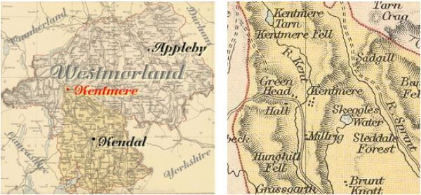
Kentmere is a parish in Kendal Ward. It was formerly part of the very large Kendal parish.
Nearby parishes are Long Sleddale, Over Staveley, Hugill, Troutbeck, Patterdale and Mardale.
Hide
Returns do not survive for the 'census' of 1787.
Census returns are available from the usual sources for 1841-1911.
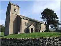
| St Cuthbert. W tower. Substantially C19th with 1950s remodelling. C16th roof. Historical and architectural notes on National Heritage List (English Heritage site). This and other photos are available on Geograph site Photograph(s) and description on VisitCumbria. Access and contact details on Church of England site |
Parish Registers and Bishop's Transcripts are held by Cumbria Archives :
originals at Kendal RO and microfilm copies at Carlisle RO.
| Baptism registers | 1701-1901 |
| Marriage registers | 1702-1974 |
| Banns registers | 1760-1974 |
| Burial registers | 1701-1812 |
| Bishops transcripts | 1813-1877 |
See the CASCAT online calogue for WPR66 for information on these and other parish records..
For searching on LDS familysearch.org see IGI batch numbers (compiled by Jake Prescott)
or use the batch number search site (by Hugh Wallis).
The University of Leicester History, Directory & Gazetteer of Cumberland & Westmorland, 1829
- Ask for a calculation of the distance from Kentmere to another place.
Records relating to the Barony of Kendale, CWAAS, William Farrer & John F. Curwen (editors) are available on British History Online (also Supplementary Records)
Cumbria County History Trust has published a "Jubilee Digest" for the township of Kentmere
Magna Britannica et Hibernia.Volume 6: Westmorland by Thomas Cox (Vicar of Bromfield, Essex) 45 pages, printed in 1731.
Transcription by Sarah Reveley, Joan Fisher and Lisl Schoenwald. (Rootsweb Westmorland Listmembers) (c) 2003
"Kontmire or Kentmeire, a small Village, famous only for the Birth of that eminent Person Bernard Gilpin, the Son of Edwin Gilpin, Esq; educated in Queens College, Oxford, where he proceeded Master of Arts, and was made Fellow thereof, being esteemed a good Disputant, and well skilled in the Greek and Hebrew Tongues. This his Eminence in Learning recommended him to be chosen one of the Masters of Christ-Church, when it was first founded for a Dean, Canons, and Students by King Hen. VIIII, but he did not continue long there, his Mother's Uncle, Cuthbert Tunstall, Bishop of Durham, sending him to travel. When he returned, the Bishop gave him the Rectory of Esington, with the Archdeaconry of Durham annexed; but he pretending them to be too burdensome for one Man to bear, was presented to Houghton in the Spring in the same County, and there settled. Preaching he made his chief Business; and that the Gospel might be both thoroughly believed and practiced, he frequently preached as well in the remote Towns as near, insomuch that he was called, The Northern Apostle. His Alms also were so frequent, equal, and constant, that he was called The common Father of the Poor; and because a good Education of poor Children is one of the greatest Charities, he boarded and kept in his own House full four and twenty Scholars, most of them poor Men's Sons upon whom he bestowed Meat and Drink, Clothes and Learning. His Hospitality was equal to his Almsgiving; for his Parish being very large, viz. consisting of fourteen Villages, he kept a publick Table for his Parisoners every Sunday from Michaelmas to Easter, which he divided into their several Degrees, of Gentlemen, Husbandmen, and the poorer Sort, and set them at several Tables; and beside treated them all at Christmas according to the common Custom. On the Death of Owen Oglethorp, Mr. Gilpin had a Conge d'Eslier to be chosen Bishop of Carlisle by Queen Elizabeth, but he refused it. A little after he erected a Grammar School at Houghton, and bestowed 460 pounds besides what was given by John Hath of Kepier, Esq; to buy Land for a Stipend for the Master and Usher, which School was settled in 1572, and out of it since, the Church hath been supplied with several learned Men. And as he abounded in good Deeds, so he was careful not only to avoid all Evil, but all Suspicions of it, so that he was accounted a Saint by all that knew him, for Enemies he could have none. He died March 4, 1582, in the 66th Year of his Age, and came to his Grave like a Shock of Corn in its Season. He was buried in the Church of Houghton, and by his Will dated Octob. 17, 1582, he left Half his Goods to the Poor of his Parish, and the other Half for Scholars and Students in Oxford. He hath written several Things, but has nothing in print but a Sermon on St. Luke 2. 41, 48, preached before the King and Court at Greenwich on the first Sunday in Epiphany in 1552, and in 1630."
You can see maps centred on OS grid reference NY455061 (Lat/Lon: 54.447279, -2.842631), Kentmere which are provided by:
- OpenStreetMap
- Google Maps
- StreetMap (Current Ordnance Survey maps)
- Bing (was Multimap)
- Old Maps Online
- National Library of Scotland (Old Ordnance Survey maps)
- Vision of Britain (Click "Historical units & statistics" for administrative areas.)
- English Jurisdictions in 1851 (Unfortunately the LDS have removed the facility to enable us to specify a starting location, you will need to search yourself on their map.)
- Magic (Geographic information) (Click + on map if it doesn't show)
- GeoHack (Links to on-line maps and location specific services.)
- All places within the same township/parish shown on an Openstreetmap map.
- Nearby townships/parishes shown on an Openstreetmap map.
- Nearby places shown on an Openstreetmap map.
Wills for Kentmere will be at Carlisle since about 1858 but before that will be at the Preston R.O. as it was in the Diocese of Chester until that time.
Hearth Tax records for 1674 Kentmere transcribed on Edenlinks.

