Hide
Kirkby Thore
hide
Hide
hide
Hide

Hide
Hide
"Kirkby Thore is so called from a temple anciently dedicated to the great idol of the Pagan-Saxons, called Thor; which was of more estimation among them , than any of the rest of their idols. This was majestically placed in a very spacious hall, and there set as if he had reposed himself upon a covered bed. On his head this idol wore a crown of gold, and round in compass above and about the same, were set or fixed 12 bright burnished golden stars; and in his right hand he held a kingly scepter. He was esteemed the god of thunder; and every Thursday was weekly dedicated unto his peculiar service, from whence that day received its name. This parish is bounded on the East by the parishes of Dufton and Marton; on the South, by the parishes of St. Michael's Appleby, Morland, and Cliburn; on the West, by the parish of Brougham; and on the North, by the parishes of Kirkland, Newbiggin and Alston: And contains about 146 families; whereof, dissenters 6. [in 1777]. The church is dedicated to St. Michael. It is a rectory."
[Nicolson & Burns: The history and antiquities of the counties of Westmorland and Cumberland. 1777. Transcribed by Anne Nichols.]
Hide
New parishes were created for the former Kirkby Thore chapelries for Temple Sowerby and Milburn, both in 1753
Hide
M.I.s for Kirkby Thore were transcribed in Monumental Inscriptions of Westmorland by E. Bellasis 1888-89 and are available on Westmorland Papers (Internet Archive).
No returns survive for the 'census' of 1787.
Census returns are available from the usual sources for 1841-1911.
Transcript and index for 1851 has been published by the Cumbria Family History Society and also in 'North Westmorland - An Index to the 1851 Census' compiled by David Lowis and Barbara Slack.
| Kirkby Thore, Congregational |

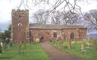
| St Michael Substantially Norman - W tower, nave and chancel, but with later windows. Memorable Norman tympanum with Norman carvings. Porch and N aisle of C14th. Historical and architectural notes on National Heritage List (English Heritage site). Photograph(s) and description on VisitCumbria. Access and contact details on Church of England site More details and maps in Genuki Westmorland Church Database |
Parish Registers and Bishop's Transcripts are held by Cumbria Archives :
originals at Kendal RO and microfilm copies at Carlisle RO.
| Baptism registers | 1593-1977 |
| Marriage registers | 1593-1979 |
| Banns registers | 1754-1930 |
| Burial registers | 1594-1912 |
| Bishops transcripts | 1674-1879 |
See the CASCAT online calogue for WPR36 for information on these and other parish records..
For searching on LDS familysearch.org see IGI batch numbers (compiled by Jake Prescott)
or use the batch number search site (by Hugh Wallis).
The University of Leicester History, Directory & Gazetteer of Cumberland & Westmorland, 1829
- Ask for a calculation of the distance from Kirkby Thore to another place.
British History Online provides historical notes for Kirkby Thore from The Later Records relating to North Westmorland by John F. Curwen (1932)
Cumbria County History Trust has published a "Jubilee Digest" for the township of Kirkby Thore
Magna Britannica et Hibernia.Volume 6: Westmorland by Thomas Cox (Vicar of Bromfield, Essex) 45 pages, printed in 1731.
Transcription by Sarah Reveley, Joan Fisher and Lisl Schoenwald. (Rootsweb Westmorland Listmembers) (c) 2003
"Kirkby-Thore, or Whelp-Castle, a small Village standing upon the River Eden, whose Lordship was in the Lord Clifford, 13 Rich. II. below which appear the vast Ruins of an antient Town, where Roman Coins and Urns are now and then dug up, and about the End of the 16th Century, this Inscription was found there, viz. DEO BELATVCAD / RO LIB VOTV / M FECIT / IOLVS.
Time has worn out the old Name quite, and the People call it at this Day, Whelp Castle, Cambden guesses, that it was the Gallagum mentioned by Ptolemy, and called by Antoninus in his Itinerary, Iter. X. Gallatum, and in some Copies Galacum, yea, Calacum, which Conjecture (he says is not only favoured by the Distances, but the present Name; for it is unusal with the Saxons to turn such British Names as begun with Gall, into Wall, as is evident from Galena, which the Saxons turned into Wallingford. It was doubless a Place of considerable Note, seeing the old military Way, (now commonly called the Maiden Way) runs through it almost directly to Caer Vorran, which our Antiquaries will have to be Walwich, which stands near the Picts Wall. Dr. Gale is of Opinion, that Catguoloph is the same that is now called Whelp, or Whellop-Castle, but the Editor of Cambden says, 'tis a Man' s Name, and not a Place's. But whether it be the old Gallagum, or not, 'tis almost certain, that the old Saxon God Thor (from whom our Thursday takes its Name) had a Temple here, and seems implied in the Name. What his Worship was, and how magnificient his Temple, we refer our Reader to Mr. V (illegible) to be informed, and shall now only take Notice of a curious Coin relating to this Idol, lately discovered here. (picture of both sides of coin)
It is about the Bigness of a silver Groat, but what it really was, and for what End it was coined, our Antiquaries dispute about several Ways. We can't spare Room to relate them all; that which is best supported, is this: Stephanus describing the God Thor, in his Notes upon Saxo Grammaticus says, That his Head (in his Image) was surrounded with a Flame like the Sun, and in his Hand he held a Seepter, which exactly agrees to the Figure on this Coin. On the Reverse are these Words, as the Learned read them: Thur gut Luetis, ie. As some interpret them, Thoris Dei facies, or Effigies, i.e. The Face or Effigies of the God Thor; but Dr. Hicks tells us the Meaning of them is, Thor Deus Patrius, ie. Thor the God of our Country. The Figures of the Half-Moon and Stars, which are stamped round the Idol, confirm this Opinion, for the Gothick Nations had the same Notion of their God Thor, that the Phoenicians had of the Sun, whom they called, The God of Heaven, to whom the Stars were all Subject, and worshipped him as such, above all other Gods; and so did the Saxons. What is said of it by others, 1. That it was an Amulet; 2. That the Figure is our Savior's, as King of Kings, and Thurgut is the Name of the Mint-Master; 3. That it is a Medal struck in Honour to the Danish Admiral who blocked up London, we pass over, as Lusus ingenioforum.
Crawdundale Waith, a Place hard by Whelp-Castle, where there appear Ditches, Rampires, and great Mounts of Earth cast up, among which was found this Roman Inscription, cut in a rough Sort of a Rock, but the fore Part worn away with Age. (Untranscribable)
This (S with an umelot) is set down in the last Edition of Cambden, but Mr. Burton on the Itin. P. 126, puts a C instead of it, which seems more agreeable to the Reading. Plus Mr. Burton gives us this for the whole Inscription.
It thus read: Varronius Prafectus Legionis Vicefime Vatentis ViEtricis, AElius Lacanus Prefectus Legionis fecunda Augufte caftrametati funt. The Manner of Graving, the one rude and deep, the other in a finer Character, proves them to be different Inscriptions, of which this may be the Interpretation. The first of them imports, That Varonius, who with his Legion lay at Deva, or West-Chester; and the other, that Lucanus, who was in Garrison with the seconti Augustan Legion at Isea or Carleon in Wales, being both detached against the Enemies in those Parts, pitched their Camps for some Time in this Place; and 'tis probable that the Officers in Memory therof might engrave these Lines on the Rock. Mr. Machel, late Minister of Kirby-Thore, who made a Collectionof the Antiquities of this County, in order to compose the History of it, found here the following Inscription, never before observed, viz. (Untranscribable) but we do not find any that have attempted to read it, and so must leave it to bolder and more experienced Antiquaries to spell out the Meaning of it."
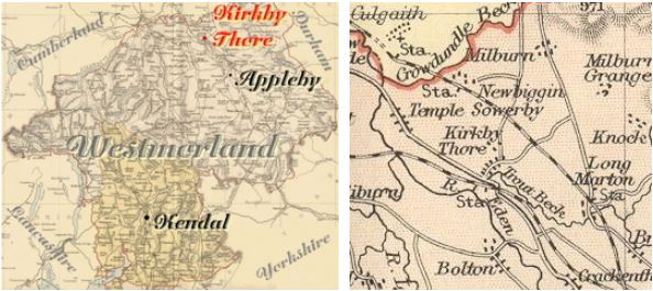
You can see maps centred on OS grid reference NY640266 (Lat/Lon: 54.633568, -2.559428), Kirkby Thore which are provided by:
- OpenStreetMap
- Google Maps
- StreetMap (Current Ordnance Survey maps)
- Bing (was Multimap)
- Old Maps Online
- National Library of Scotland (Old Ordnance Survey maps)
- Vision of Britain (Click "Historical units & statistics" for administrative areas.)
- English Jurisdictions in 1851 (Unfortunately the LDS have removed the facility to enable us to specify a starting location, you will need to search yourself on their map.)
- Magic (Geographic information) (Click + on map if it doesn't show)
- GeoHack (Links to on-line maps and location specific services.)
- All places within the same township/parish shown on an Openstreetmap map.
- Nearby townships/parishes shown on an Openstreetmap map.
- Nearby places shown on an Openstreetmap map.
Kirkby Thore is in the diocese of Carlisle and wills will be in Carlisle Record Office.
Hearth Tax records for 1674 Kirkby Thore transcribed on Edenlinks
Window Tax records for 1777 Kirkby Thore transcribed on Edenlinks.
