Hide
Milburn
hide
Hide
hide
Hide

Hide
Hide
"MILBURN, a chapelry in the parish of KIRKBY-THORE, EAST ward, county of WESTMORLAND, 7 miles (N. by "W.) from Appleby, containing, with Milburn- Grange, 303 inhabitants. The living is a perpetual curacy, in the archdeaconry and diocese of Carlisle, endowed with £500 private benefaction, and £400 royal bounty, and in the. patronage of the Earl of Thanet. The chapel, dedicated to St. Cuthbert, was founded by William de Lancaster, about 1355. Sarah Atkinson, in 1790, left £ 100 for the education of poor children, the interest of which is about £4. 10. a year. "
[From Samuel Lewis A Topographical Dictionary of England (1831) - copyright Mel Lockie 2016]
Hide
Milburn became a parish in 1753. It was formerly part of Kirkby Thore parish in the East Ward of the county.
It is an attractive sandstone village around the green complete with maypole. Milburn is derived from 'the mill stream'.
Hide
Returns survive for the 'census' of 1787 and are held at the Kendal Record Office of Cumbria Archives Service. The Record Office reference is WQ/SP/C. They are transcribed in Vital Statistics published by Curwen Archives Trust.
Census returns are available from the usual sources for 1841-1911.
Transcript and index for 1851 has been published by the Cumbria Family History Society and also in 'North Westmorland - An Index to the 1851 Census' compiled by David Lowis and Barbara Slack.

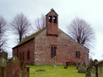
| St Cuthbert Late Norman S doorway. The chancel also has Norman work. The nave has an early C14th aisle. There is a bellcote of 1616. Historical and architectural notes on National Heritage List (English Heritage site). Photograph(s) and description on VisitCumbria. Access and contact details on Church of England site More details and maps in Genuki Westmorland Church Database |
Parish Registers and Bishop's Transcripts are held by Cumbria Archives :
originals at Kendal RO and microfilm copies at Carlisle RO.
| Baptism registers | 1678-1932 |
| Marriage registers | 1679-1966 |
| Banns registers | 1754-1968 |
| Burial registers | 1678-1978 |
| Bishops transcripts | 1682-1888 |
See the CASCAT online calogue for WPR47 for information on these and other parish records..
For searching on LDS familysearch.org see IGI batch numbers (compiled by Jake Prescott)
or use the batch number search site (by Hugh Wallis).
The registers for 1672-1812 have been transcribed by Roland Grigg: (A to G) : (H to R) : (S to Z)
These are included in a combined Cumbrian parish register index (available through Wayback Machine Internet Archive) .
The University of Leicester History, Directory & Gazetteer of Cumberland & Westmorland, 1829
- Ask for a calculation of the distance from Milburn to another place.
Cumbria County History Trust has published a "Jubilee Digest" for the township of Milburn
Magna Britannica et Hibernia.Volume 6: Westmorland by Thomas Cox (Vicar of Bromfield, Essex) 45 pages, printed in 1731.
Transcription by Sarah Reveley, Joan Fisher and Lisl Schoenwald. (Rootsweb Westmorland Listmembers) (c) 2003
"Milburn, or Milneborn, the Lordship of the aforesaid Lord Clifford 4th, left to his Son Thomas, with other his large Estates, as above mentioned, as was also Murtone another Village, as also
Howgill Castle, situate upon Burnibeck, a small River at a little Distance from the Maiden-way Northward, belonging to the antient Family of Sandfords, who were in their Time of great Repute, for Sir Walter Sandford was Knight of the Shire for this County 15 Edw. II. And Sir Robert de Sandford was Knight of the Shire for this County 16 and 19 Years of King Edw. II. His Son Robert as we suppose, was so acceptable to the Men of this County, that he served for them in Parliament many Times in the Reign of King Edw. III. Viz, 1, 2, 3, 6, 7, 9, 14, and the 17 and 18 Years of that Reign, and Thomas de Sandford and William de Sandford 20th."
Milburn was originally held by Wetheral Priory. In the time of King John it transferred to the de Stuteville then to the de Veteriponts then to the Cliffords.
The C14th Howgill Castle was owned by the Lord of the Manor Colonel Honeywood who was wounded in the last battle on English soil - the skirmish at Clifton Moor in 1745.
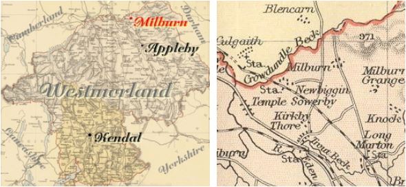
You can see maps centred on OS grid reference NY700310 (Lat/Lon: 54.673059, -2.465959), Milburn which are provided by:
- OpenStreetMap
- Google Maps
- StreetMap (Current Ordnance Survey maps)
- Bing (was Multimap)
- Old Maps Online
- National Library of Scotland (Old Ordnance Survey maps)
- Vision of Britain (Click "Historical units & statistics" for administrative areas.)
- English Jurisdictions in 1851 (Unfortunately the LDS have removed the facility to enable us to specify a starting location, you will need to search yourself on their map.)
- Magic (Geographic information) (Click + on map if it doesn't show)
- GeoHack (Links to on-line maps and location specific services.)
- All places within the same township/parish shown on an Openstreetmap map.
- Nearby townships/parishes shown on an Openstreetmap map.
- Nearby places shown on an Openstreetmap map.
Milburn is in the diocese of Carlisle and wills will be in Carlisle Record Office.
Hearth Tax records for 1674 Milburn transcribed on Edenlinks.
Window Tax records for 1777 Milburn transcribed on Edenlinks.
