Hide
Ormside
hide
Hide
hide
Hide

Hide
Hide
"Ormside is a corruption (as most of the names of places and persons have been corrupted in ignorant times) or Ormes-head, or (which is the same) Ormesheved: And had its name probably from some owner of the name of Orme. This parish is bounded on the East by the parish of Warcop; on the South, by the parishes of Warcop and Asby; on the West, by the parish of St. Laurence Appleby; and on the North, by the parishes of St. Laurence and St. Michael's Appleby. Who the church was dedicated to we have not found. It is a rectory, in the patronage of the bishop of Carlisle. The church of Ormeside, as also the parish, is but small. It stands near unto the hall. It has a tower steeple, with two little bells. In the manor of Ormeside there are two hamlets or villages, distinguished by the names of Great Ormside and Little Ormside. Great Ormside is pleasantly situate, on the south side of the river Eden; and contains about 20 families [in 1777] . Little Ormside, about half a mile south-east from the church, contains about eight or nine families [in 1777]. "
[Nicolson and Burn: The history and antiquities of the counties of Westmorland and Cumberland. 1777. Transcribed by Anne Nichols.]
Hide
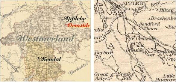
This parish is bounded on the East by the parish of Warcop; on the South, by the parishes of Warcop and Asby;
on the West, by the parish of St. Laurence Appleby; and on the North, by the parishes of St. Laurence and St. Michael's Appleby.
Hide
M.I.s for Ormside were transcribed in Monumental Inscriptions of Westmorland by E. Bellasis 1888-89 and are available on Westmorland Papers.
| St James, Ormside, Church of England |
Returns survive for the 'census' of 1787 and are held at the Kendal Record Office of Cumbria Archives Service. The Record Office reference is WQ/SP/C. They are transcribed in Vital Statistics published by Curwen Archives Trust 1992. ISBN 1897590008.
Census returns are available from the usual sources for 1841-1911.
Transcript and index for 1851 has been published by the Cumbria Family History Society and also in 'North Westmorland - An Index to the 1851 Census' compiled by David Lowis and Barbara Slack.
| St James, Ormside, Church of England |
| Catherine Holme, Wesleyan Methodist |
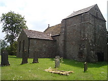
St James Massive Norman W tower. Much of the rest of the church is C16th with an C18th N chapel. Victorian porch, chancel arch and vestry. This and other photographs are on the Geograph site. Historical and architectural notes on National Heritage List (English Heritage site). History and description on Wikipedia. Photograph(s) and description on VisitCumbria. Access and contact details on Church of England site |
Parish Registers and Bishop's Transcripts are held by Cumbria Archives :
originals at Kendal RO and microfilm copies at Carlisle RO.
| Baptism registers | 1560-1812 |
| Marriage registers | 1560-1971 |
| Banns registers | 1755-1812 |
| Burial registers | 1560-1812 |
| Bishops transcripts | 1662-1881 |
See the CASCAT online calogue for WPR2 for information on these and other parish records..
For searching on LDS familysearch.org see IGI batch numbers (compiled by Jake Prescott)
or use the batch number search site (by Hugh Wallis).
The University of Leicester History, Directory & Gazetteer of Cumberland & Westmorland, 1829
- Ask for a calculation of the distance from Ormside to another place.
British History Online provides historical notes for Ormside from The Later Records relating to North Westmorland by John F. Curwen (1932)
Cumbria County History Trust has published a "Jubilee Digest" for the township of Ormside
Magna Britannica et Hibernia.Volume 6: Westmorland by Thomas Cox 45 pages, printed in 1731.
Transcription by S Reveley, J Fisher and L Schoenwald.
"Ormside, or Ormshed, the Lordship and Estate of Roger Lord Clifford 4th, of which he died possessed with other great Estates, 13 Rich. II and left it, as is said of them above. It was antiently, viz. in the Reign of King Edw. I. the Seat of the Hiltons, who were originally of the County of Durham, and sat in Parliament among the Barons from the 23 Edw. I. to 9 Edw. III. after which Time we have no Account of them."
You can see maps centred on OS grid reference NY702156 (Lat/Lon: 54.53448, -2.462257), Ormside which are provided by:
- OpenStreetMap
- Google Maps
- StreetMap (Current Ordnance Survey maps)
- Bing (was Multimap)
- Old Maps Online
- National Library of Scotland (Old Ordnance Survey maps)
- Vision of Britain (Click "Historical units & statistics" for administrative areas.)
- English Jurisdictions in 1851 (Unfortunately the LDS have removed the facility to enable us to specify a starting location, you will need to search yourself on their map.)
- Magic (Geographic information) (Click + on map if it doesn't show)
- GeoHack (Links to on-line maps and location specific services.)
- All places within the same township/parish shown on an Openstreetmap map.
- Nearby townships/parishes shown on an Openstreetmap map.
- Nearby places shown on an Openstreetmap map.
Hearth Tax records for 1674 Great Ormside transcribed on Edenlinks.
Hearth Tax records for 1674 Little Ormside transcribed on Edenlinks.
Window Tax records for 1777 Ormside transcribed on Edenlinks.

 (c) David McMumm