Hide
Bishop Wilton
hide
Hide
hide
Hide
Hide
The Ancient Parish of BISHOP WILTON
[Transcribed information mainly from the early 1820s]
"BISHOP WILTON, a parish in the wapentake of Harthill, and liberty of St. Peters; 4 miles N. of Pocklington. The church is an ancient structure, dedicated to St. Michael (see Churches for photograph), the Rev. William Metcalfe is the vicar, and Sir Mark Masterman Sykes, lord of the manor, the patron. Pop 570."Bishop Neville formerly resided in this parish, which gave rise to the name of Bishop-Wilton. Here is a field moated round, where his palace stood to this day, and the Neville's Arms are, on painted glass, in one of the windows of the church.""
"BOLTON, in the parish of Bishop Wilton, wapentake of Harthill, and liberty of St. Peter's; 2¼ miles SW. of Bishop Wilton, 3¼ miles NW. of Pocklington. (Bolton-Hall, the seat of John Preston, Esq.) There is here no place of Worship except a small Methodist chapel. Pop. 112."
"GARROWBY NEW INN, in the township and parish of Bishop-Wilton; 12 miles from York and Sledmere."
"GOWTHORPE, in the parish of Bishop Wilton, wapentake of Harthill and liberty of St. Peter's; 2¼ miles W. of Bishop Wilton, 4 miles NW. of Pocklington. Population, (included with Youlthorpe) 111."
"GREENWICK, a single house in the parish of Bishop Wilton, and wapentake of Harthill; 3 miles ENE. of Bishop Wilton, 5 miles NE. of Pocklington."
"HIGH BELTHORPE, in the parish of Bishop Wilton, wapentake of Harthill and liberty of St. Peter's; 1 mile WSW. of Bishop Wilton, 5 miles N. of Pocklington. Population included with Bishop Wilton."
"YOULTHORPE, in the parish of Bishop Wilton, wapentake of Harthill, and liberty of St. Peter's; 2 miles W. of Bishop Wilton, 5 miles NNW. of Pocklington. Population including Gowthorpe, 111."
[Description(s) edited mainly from various 19th century sources by Colin Hinson. ©2010]
Hide
- Photographs of the over 360 gravestones and plaques at Bishop Wilton with linked surname index.
- Photographs of the over 38 gravestones at Bolton with linked surname index.
- Here are photographs of Churches etc. in the parish:
- St. Edith's Church, Bishop Wilton (view 1).
- Internal view looking down the aisle
- The Font and Font cover
- St. Edith's Church, Bishop Wilton (view 2).
- The old Methodist Chapel (1810), Bishop Wilton.
- The Methodist Church, Bolton. (The Church's website is here.)
- St. Edith's Church, Bishop Wilton (view 1).
- Transcript of the entry for Bishop Wilton in the "Collections relative to Churches and Chapels".
- Transcript of the entry for Bolton in the "Collections relative to Churches and Chapels".
- The whereabouts and dates of the Registers etc. for the Parish of Bishop Wilton.
- The List of Vicars in St. Edith's Church, Bishop Wilton.
- Transcript of the entry of "professions and trades" in the Baines's Directory of 1823, of the East Riding.
- Transcript of the entry of "professions and trades" in the Bulmers Directory of 1892. of the East Riding.
- There is further information about this parish from the Pigot's 1834 Directory, Yorkshire section.
- There is further information about this parish from the National Gazetteer 1868, Yorkshire extracts.
- There is further information about this parish from the Lewis's Topographical Dictionary of England 1835, Yorkshire extracts.
- There is further information about this parish from the Stephen Whatley's Gazetteer 1750, Yorkshire extracts.
- There is further information about this parish from the Bulmer's 1892 History and Directory of the East Riding.
- Ask for a calculation of the distance from Bishop Wilton to another place.
- Andrew Sefton has transcribed the following from documents at the Brynmor Jones Library at Hull University.
- A list of the Tenants of the Manor of Bishop Wilton for the year 1765.
- A list of the Tenants of the Manor of Bishop Wilton for the year 1610-11.
- A list of the Proprietors of Bishop Wilton for the year 1769.

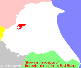
- For a detailed map of this parish see this parish boundaries map.
- For a more detailed map of the parishes in the riding please see the Yorkshire parish maps page.
- For a more detailed map of the county please see the Yorkshire map page.
- Here is a map showing the wapentakes for the county.
You can see maps centred on OS grid reference SE797551 (Lat/Lon: 53.985814, -0.786036), Bishop Wilton which are provided by:
- OpenStreetMap
- Google Maps
- StreetMap (Current Ordnance Survey maps)
- Bing (was Multimap)
- Old Maps Online
- National Library of Scotland (Old Ordnance Survey maps)
- Vision of Britain (Click "Historical units & statistics" for administrative areas.)
- English Jurisdictions in 1851 (Unfortunately the LDS have removed the facility to enable us to specify a starting location, you will need to search yourself on their map.)
- Magic (Geographic information) (Click + on map if it doesn't show)
- GeoHack (Links to on-line maps and location specific services.)
- All places within the same township/parish shown on an Openstreetmap map.
- Nearby townships/parishes shown on an Openstreetmap map.
- Nearby places shown on an Openstreetmap map.
- The 1914-18 War Memorial at Bishop Wilton.
- This parish is covered (or partly covered) by the following Societies:
- The 1834 Electoral Roll for this parish

