
Hide
Low Catton
Hide
Maintainers
The updates have been applied on the "anchor" issue on 27 July.
The issues are discussed here
Details are also on the maintainers list.
hide
Hide
hide
Hide
Hide
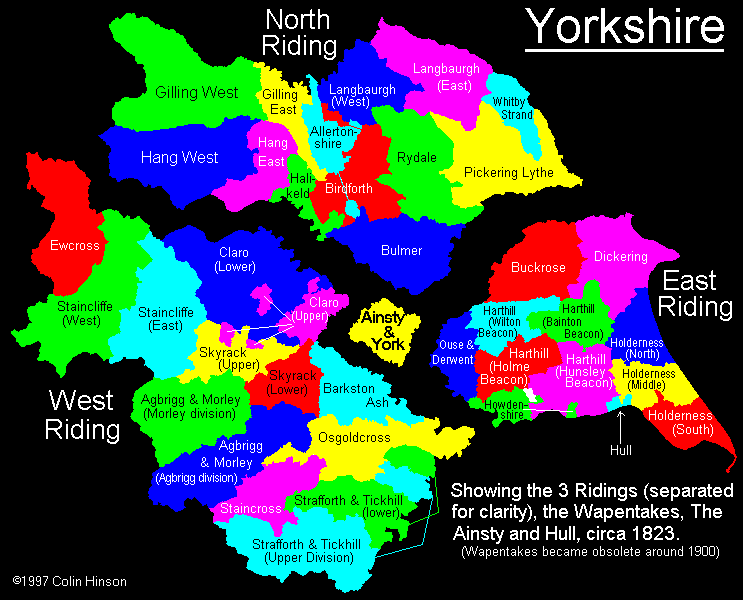
The Ancient Parish of LOW CATTON
[Transcribed information mainly from the early 1820s]
"LOW CATTON, a parish in the wapentake of Harthill; 7½ miles ENE. of York. The church (see Churches for photograph), which is a rectory dedicated to All Saints, is in the patronage of the Earl of Egremont. The Rev. F. H. R. Stanhope is rector. Population 177. There is a Free Grammar School at High Catton, for teaching a limited number or scholars;"Information on the following places in this Parish is contained on a supplementary page.
|
[Description(s) edited mainly from various 19th century sources by Colin Hinson. ©2010]
Hide
- Photographs of the over 380 gravestones in Low Catton Churchyard with a surname index.
- Photographs of the over 380 gravestones in Stamford Bridge Churchyard with a surname index.
- Photographs of the over 90 gravestones in Kexby Churchyard with a surname index.
- Here are photographs of Churches in the parish:
- All Saints' Church, Low Catton.
- St. John the Baptist's Church, Stamford Bridge.
- Internal view looking down the aisle('washed out'
- The East Window
- The font
- The outside font
- The former Methodist Church, Stamford Bridge.
- St Paul's Church, Kexby. (With short history).
- The former Wesleyan Methodist Church, High Catton (view 1). This was built in 1899 to replace a chapel built in 1810.
- The ex-Wesleyan Methodist Church, High Catton (view 2).
- St. Paul's Church, Kexby also had its own web-site, there is also some additional information about Kexby on this site.
This has now gone dead, if you know where it went, please drop me a line.
- Transcript of the entry for Low Catton in the "Collections relative to Churches and Chapels".
- The whereabouts and dates of the Registers etc. for the Parish of Low Catton.
- The List of Incumbents in Low Catton church.
- Transcript of the entry of "professions and trades" in the Baines's Directory of 1823, of the East Riding.
- Transcript of the entry of "professions and trades" in the The Post Office Directory of the, East and North Ridings, 1857
- Transcript of the entry of "professions and trades" in the Bulmers Directory of 1892. of the East Riding.
- There is further information about this parish from the National Gazetteer 1868, Yorkshire extracts.
- There is further information about this parish from the Lewis's Topographical Dictionary of England 1835, Yorkshire extracts.
- There is further information about this parish from the Stephen Whatley's Gazetteer 1750, Yorkshire extracts.
- There is further information about this parish from the Bulmer's 1892 History and Directory of the East Riding.
- Ask for a calculation of the distance from Low Catton to another place.
- In 1853, the township of Kexby, formerly in the parish of Low Catton, was formed into the parish of Kexby.
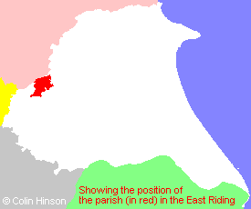
- For a detailed map of this parish see this parish boundaries map.
- For a more detailed map of the parishes in the riding please see the Yorkshire parish maps page.
- For a more detailed map of the county please see the Yorkshire map page.
- Here is a map showing the wapentakes for the county.
You can see maps centred on OS grid reference SE705538 (Lat/Lon: 53.975467, -0.926611), Low Catton which are provided by:
- OpenStreetMap
- Google Maps
- StreetMap (Current Ordnance Survey maps)
- Bing (was Multimap)
- Old Maps Online
- National Library of Scotland (Old Ordnance Survey maps)
- Vision of Britain (Click "Historical units & statistics" for administrative areas.)
- English Jurisdictions in 1851 (Unfortunately the LDS have removed the facility to enable us to specify a starting location, you will need to search yourself on their map.)
- Magic (Geographic information) (Click + on map if it doesn't show)
- GeoHack (Links to on-line maps and location specific services.)
- All places within the same township/parish shown on an Openstreetmap map.
- Nearby townships/parishes shown on an Openstreetmap map.
- Nearby places shown on an Openstreetmap map.
- The 1914-1918 War Memorial in Low Catton Churchyard.
- The World War I Memorial Plaque in Low Catton Church.
- The World War I Memorial Plaque in Low Catton Church.
- This parish is covered (or partly covered) by the following Societies:
- The 1834 Electoral Roll for this parish