Hide
Crayke
hide
Hide
hide
Hide
Hide
The Ancient Parish of CRAYKE
[Transcribed information mainly from the early 1820s]
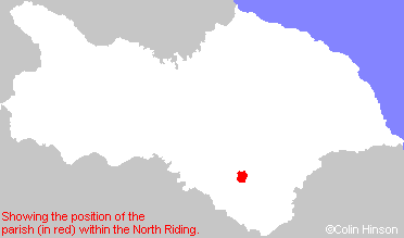
"CRAYKE, (and CRAYKE CASTLE) a parish in the Bishopric of Durham, though locally situated in the wapentake of Bulmer; 2 miles E. of Easingwold. Crayke, with the land three miles round it, was given by Egfrid, King of Northumberland, to St. Cuthbert, in the year 685, by whom it came to the church of Durham; about which time the said St. Cuthbert founded a monastery here. This village is delightfully situated on the southern declivity of a lofty detached hill or mount, on the summit of which stands the ruins of Crayke Castle, which is supposed to have been a Roman fortress, and which in the time of the Saxons was a royal palace. From hence is a most extensive and delightful prospect of the forest of Galtres, and the beautiful and picturesque vale of Mowbray; so called from its ancient owner Roger de Mowbray, who was bowman to William Rufus, and possessed one hundred and forty manors in England and twenty in Normandy. He was the founder of the monasteries of Newborough and Byland. Near the ruins of the castle (which is now occupied as a farm house) stands the church, a handsome antique edifice inclosed within lofty trees, and which is dedicated to St. Cuthbert. The living is a rectory, in the patronage of the Bishop of Durham. In addition to the parish church (see Churches for photograph), here is a Catholic chapel, of which the Rev. Thomas Coupe is minister; likewise a Methodist chapel. The freeholders in this place vote for knights for the county of Durham; pleas of land are held in the county of Durham, and the jurisdiction of the palatine extends thereto; but in the militia service the legislature thought it expedient to embody the inhabitants with the men of Yorkshire. Population, 538." [Description(s) edited mainly from various 19th century sources by Colin Hinson. ©2010]
Hide
- Here is a photograph of St. Cuthbert's Church, Crayke.
- Internal view looking down the aisle
- The font
- Transcript of the entry for Crayke in the "Collections relative to Churches and Chapels".
- The whereabouts and dates of the Registers etc. for the Parish of Crayke.
- The List of Incumbents in St. Cuthbert's Church, Crayke.
- Transcript of the entry of "professions and trades" in the Baines's Directory of 1823, of the North Riding.
- Transcript of the entry of "professions and trades" in the White's Directory of 1840, Yorkshire section.
- Transcript of the entry of "professions and trades" in the Bulmers Directory of 1890. of the North Riding.
- There is further information about this parish from the National Gazetteer 1868, Yorkshire extracts.
- There is further information about this parish from the Lewis's Topographical Dictionary of England 1835, Yorkshire extracts.
- There is further information about this parish from the Bulmer's 1890 History and Directory of the North Riding.
- Ask for a calculation of the distance from Crayke to another place.

- For a detailed map of this parish see this parish boundaries map.
- For a more detailed map of the parishes in the riding please see the Yorkshire parish maps page.
- For a more detailed map of the county please see the Yorkshire map page.
- Here is a map showing the wapentakes for the county.
You can see maps centred on OS grid reference SE562705 (Lat/Lon: 54.127292, -1.141518), Crayke which are provided by:
- OpenStreetMap
- Google Maps
- StreetMap (Current Ordnance Survey maps)
- Bing (was Multimap)
- Old Maps Online
- National Library of Scotland (Old Ordnance Survey maps)
- Vision of Britain (Click "Historical units & statistics" for administrative areas.)
- English Jurisdictions in 1851 (Unfortunately the LDS have removed the facility to enable us to specify a starting location, you will need to search yourself on their map.)
- Magic (Geographic information) (Click + on map if it doesn't show)
- GeoHack (Links to on-line maps and location specific services.)
- All places within the same township/parish shown on an Openstreetmap map.
- Nearby townships/parishes shown on an Openstreetmap map.
- Nearby places shown on an Openstreetmap map.
- The World War I Roll of Honour in St. Cuthbert's Church, Crayke.
- This parish is covered by the following Society:

