Hide
Ingleby Arncliffe
hide
Hide
hide
Hide
Hide
hide
Hide
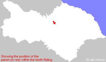
The Ancient Parish of INGLEBY ARNCLIFFE
[Transcribed information mainly from the early 1820s]
"INGLEBY ARNCLIFFE, a parish in the wapentake and liberty of Langbargh; 8 miles NE. of Northallerton. The church, which is dedicated to St. Andrew, is a small plain ancient structure; the living is a perpetual curacy, in the patronage of Brian Abbes, Esq. and the Rev. J. W. Steele is the incumbent. The village of Ingleby, which is the only one in the parish, is small and consists chiefly of farm houses, neatly built. It stands in a retired situation, on the summit of a gentle ridge, at a little distance from the road leading from Stokesley to Thirsk. A little south of the village is situated the Cleveland Tontine Inn. Pop. 331.""CLEVELAND TONTINE INN, in the township and parish of Ingleby Arncliffe, west-division of Langbarugh; 1¼ miles SW of Ingleby Arncliffe, 7 miles from Northallerton, 8 from Yarm, 9 from Stokesley, 12 from Thirsk.
The foundation of this Inn, which was designed on an extensive and elegant plan, was laid on the 13th day of July, 1804, for the purpose of establishing a daily post between Thirsk, Guisborough, Yarm, &c. for the accommodation of the inhabitants of Cleveland, and which commenced on the 5th of September following, was raised by subscription in the nature of a Tontine, called the Cleveland Tontine-Inn. --Graves' Cleveland."
"COCK BUSH, a farm house in the township and parish of Ingleby Arncliffe; 1 mile WSW. of Ingleby Arncliffe, 8 miles from Northallerton and Stokesley."
"FOWGILL, in the parish of Ingleby Arncliffe, wapentake and liberty of Langbargh; 1 mile NW. of Ingleby Arncliffe, 8 miles from Stokesley."
"INGLEBY CROSS, a hamlet in the township and parish of Ingleby Arncliffe; ½ mile W. of Ingleby Arncliffe."
[Description(s) edited mainly from various 19th century sources by Colin Hinson. ©2010]
Hide
- Here are photographs of Churches etc. in the parish:
- All Saints' Church, Ingleby Arncliffe.
- Internal view looking down the aisle, showing the box pews
- All Saints' Church, Ingleby Arncliffe.
- The Methodist Church, Ingleby Arncliffe. (Originally Wesleyan, build 1863).
- All Saints' Church, Ingleby Arncliffe.
- Transcript of the entry for Ingleby Arncliffe in the "Collections relative to Churches and Chapels".
- The whereabouts and dates of the Registers etc. for the Parish of Ingleby Arncliffe.
- Transcript of the entry of "professions and trades" in the Baines's Directory of 1823, of the North Riding.
- Transcript of the entry of "professions and trades" in the Bulmers Directory of 1890. of the North Riding.
- There is further information about this parish from the National Gazetteer 1868, Yorkshire extracts.
- There is further information about this parish from the Lewis's Topographical Dictionary of England 1835, Yorkshire extracts.
- There is further information about this parish from the Bulmer's 1890 History and Directory of the North Riding.
- Ask for a calculation of the distance from Ingleby Arncliffe to another place.
- John Harris has written a short article on the Manor of Arncliffe and the Mauleverers.

- For a detailed map of this parish see this parish boundaries map.
- For a more detailed map of the parishes in the riding please see the Yorkshire parish maps page.
- For a more detailed map of the county please see the Yorkshire map page.
- Here is a map showing the wapentakes for the county.
You can see maps centred on OS grid reference NZ457008 (Lat/Lon: 54.400623, -1.297563), Ingleby Arncliffe which are provided by:
- OpenStreetMap
- Google Maps
- StreetMap (Current Ordnance Survey maps)
- Bing (was Multimap)
- Old Maps Online
- National Library of Scotland (Old Ordnance Survey maps)
- Vision of Britain (Click "Historical units & statistics" for administrative areas.)
- English Jurisdictions in 1851 (Unfortunately the LDS have removed the facility to enable us to specify a starting location, you will need to search yourself on their map.)
- Magic (Geographic information) (Click + on map if it doesn't show)
- GeoHack (Links to on-line maps and location specific services.)
- All places within the same township/parish shown on an Openstreetmap map.
- Nearby townships/parishes shown on an Openstreetmap map.
- Nearby places shown on an Openstreetmap map.
- This parish is covered by the following Society:

