Hide
Kirby Misperton
hide
Hide
hide
Hide
Hide
The Ancient Parish of KIRBY MISPERTON
[Transcribed information mainly from the early 1820s]
"KIRBY MISPERTON, (or Kirkby over Carr) a parish in the wapentake and liberty of Pickering Lythe (the seat of the Rev. F.W. Blomberg); 4 miles SSW. of Pickering. The church is dedicated to St. Lawrence (see Churches for photograph), and the living is a rectory, in the patronage of Charles Duncombe, Esq. Here is also a Free School, salary £10. per annum. Pop. 170.Here was born, in 1703, the Rev. John Clarke, M.A. whose life has been given to the public by the late Dr. Zouch, under the title of "the Good School-master exemplified, in the character of the Rev. John Clarke, M.A." He was the son of an honest and industrious mechanic, whose extreme anxiety to give him a liberal education deserves every encomium. The Rector of the parish, (Mr. Peter Dubordieu, M.A.) quick to discern and willing to encourage merit, placed him in the school at Thorton, a village in the neighbourhood, whence he subsequently obtained a small exhibition to assist him at the University. He died at Scarborough, in the house of his brother Mr. Francis Clarke. He was buried at the Church of Kirkby-Misperton, Feb. 11, 1761, where an elegant Monument has been erected to his memory, at the expense of not less than 148 of the sons of the principal gentry in the county of York, as well as those of other counties, all his pupils. A plain marble tablet is also placed in each of the schools over which he presided, with inscriptions by Dr Zouch,"
"GREAT BARUGH, (and Little Barugh), in the parish of Kirby-Misperton, and being united with Great-Barugh, form the township of Barughs-Ambo; 2 miles W. of Kirby Misperton, 5 miles SW. of Pickering. Population, 241."
"GREAT HABTON, (and Little Habton) in the parish of Kirby Misperton, wapentake and liberty of Pickering Lythe; 2¼ miles SSW. of Kirby Misperton, 4 miles NW. of Malton. Pop. 186. (see also Churches)"
"LUND FOREST, or Low Moors, 4 farm houses in the township of Ryton, and parish of Kirby Misperton; 4 miles from Malton, 5 from Pickering, 12 from Kirbymoorside."
"RYTON, in the parish of Kirby Misperton, wapentake and liberty of Pickering Lythe; 2½ miles SSE. of Kirby Misperton, 3 miles N. of Malton. Population, 212."
[Description(s) edited mainly from various 19th century sources by Colin Hinson. ©2010]
Hide
- Here are photographs of Churches in the parish:
- St. Laurence's Church, Kirby Misperton.
- Internal view looking down the aisle
- The font
- St. Chad's Church, Great Habton.
- Internal view looking down the aisle
- The Wesleyan Chapel, Kirby Misperton.
- St. Laurence's Church, Kirby Misperton.
- Transcript of the entry for Kirby Misperton in the "Collections relative to Churches and Chapels".
- The whereabouts and dates of the Registers etc. for the Parish of Kirby Misperton.
- The List of Rectors in St. Laurence's Church, Kirby Misperton.
- Transcript of the entry of "professions and trades" in the Baines's Directory of 1823, of the North Riding.
- Transcript of the entry of "professions and trades" in the White's Directory of 1840, Yorkshire section.
- Transcript of the entry of "professions and trades" in the Bulmers Directory of 1890. of the North Riding.
- There is further information about this parish from the National Gazetteer 1868, Yorkshire extracts.
- There is further information about this parish from the Lewis's Topographical Dictionary of England 1835, Yorkshire extracts.
- There is further information about this parish from the Stephen Whatley's Gazetteer 1750, Yorkshire extracts.
- There is further information about this parish from the Bulmer's 1890 History and Directory of the North Riding.
- Ask for a calculation of the distance from Kirby Misperton to another place.
- The Kirby Misperton History web-site contains additional 19th century directory transcriptions, census returns, old photographs etc.

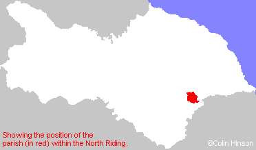
- For a detailed map of this parish see this parish boundaries map.
- For a more detailed map of the parishes in the riding please see the Yorkshire parish maps page.
- For a more detailed map of the county please see the Yorkshire map page.
- Here is a map showing the wapentakes for the county.
You can see maps centred on OS grid reference SE779795 (Lat/Lon: 54.205336, -0.807207), Kirby Misperton which are provided by:
- OpenStreetMap
- Google Maps
- StreetMap (Current Ordnance Survey maps)
- Bing (was Multimap)
- Old Maps Online
- National Library of Scotland (Old Ordnance Survey maps)
- Vision of Britain (Click "Historical units & statistics" for administrative areas.)
- English Jurisdictions in 1851 (Unfortunately the LDS have removed the facility to enable us to specify a starting location, you will need to search yourself on their map.)
- Magic (Geographic information) (Click + on map if it doesn't show)
- GeoHack (Links to on-line maps and location specific services.)
- All places within the same township/parish shown on an Openstreetmap map.
- Nearby townships/parishes shown on an Openstreetmap map.
- Nearby places shown on an Openstreetmap map.
- The World War I Roll of Honour in St. Laurence's Church, Kirby Misperton.
- The 1914-19 Memorial Plaque in Kirby Misperton Church.
- The War Memorial at Kirby Misperton.
- This parish is covered (or partly covered) by the following Societies:

