Hide
South Kilvington
hide
Hide
hide
Hide
Hide
hide
Hide
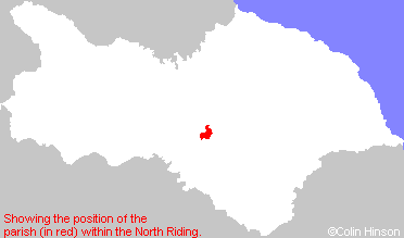
The Ancient Parish of SOUTH KILVINGTON
[Transcribed information mainly from the early 1820s]
"SOUTH KILVINGTON, a parish in the wapentake of Birdforth; 1 mile N. of Thirsk. The Church here is dedicated to St. Wilfred (see Churches for photograph); the living is a rectory, in the patronage of Sydney College, Cambridge. Pop. 260.In this Church is a Baptismal Font, made about the time of Edward IV. on which is engraved the arms of the Scropes of Bolton and Upsal. The constant tradition of the neighbourhood has been, that it was removed to its present situation from the chapel of Upsal Castle, in this parish.- For particulars of this Font, see Archaeologia, vol. XL."
"THORNBROUGH, in the parish of South Kilvington and wapentake of Birdforth; ½ mile N. of South Kilvington, 2 miles NNE. of Thirsk. Population, 27."
"UPSALL, in the parish of South Kilvington, and wapentake of Birdforth; 2½ miles NE. of South Kilvington, 4 miles NNE. of Thirsk, in an elevated situation upon the Hambleton hills. The Mowbrays, succeeded by the Scropes, had formerly a castle here.
The ancient family of Scropes were lords of Masham and Upsall; Sir Geoffrey le Scrope, Chief Justice of England in the reigns of Edward II. and Edward III. being Lord thereof. The last male branch of the Scropes who held this manor and castle, was the second Thomas, Lord Scrope, whose sister, Elizabeth, married Sir Ralph Fitzrandolph, and with her went the castle of Upsall. --Archaeol. vol. xvi. What little remains here, have been converted into a farm house and out-offices. In 1814 some remains of a round tower at the north-west corner were to be seen. It is now the property of Mr. Peters, bequeathed to him by the late Dr. Turton. Population in 1821, 118."
[Description(s) edited mainly from various 19th century sources by Colin Hinson. ©2010]
Hide
- Here are photographs of Churches etc. in the parish:
- St. Wilfrid's Church, South Kilvington.
- Internal view looking down the nave
- St. Wilfrid's Church, in the winter sun.
- St. Wilfrid's Church, South Kilvington.
- In 2016 the rendering was removed from the church (see Church History for more information), see photos below.
- St. Wilfrid's Church, the south and east side.
- St. Wilfrid's Church, the south and west side.
- The church in South Kilvington, was for the past hundred plus years rendered with concrete. Looked 'orrible. It closed for business in early January this year, for about nine months of chipping off and general expensive restoration work (in labour only it must have exceeded £200k). Architects, Archaeologists, Structural Engineers etc spent many man-hours deciding what to do with the fairly rotten stonework. None of them really wanted to re-render it, epoxy coatings etc were ruled out as that is detrimental to stonework. The final outcome was to leave it as bare fairly porous stone, for a few years and see what happens. Certainly looks a lot better.
I took about twenty odd pictures of the process over the months, just taken some this morning of the 'finished' project. see under " Churches" for two of these photos. Paul Sherwood 2017 - Transcript of the entry for South Kilvington in the "Collections relative to Churches and Chapels".
- The whereabouts and dates of the Registers etc. for the Parish of South Kilvington.
- The List of Rectors in St. Wilfrid's Church, South Kilvington.
- Transcript of the entry of "professions and trades" in the Baines's Directory of 1823, of the North Riding.
- Transcript of the entry of "professions and trades" in the White's Directory of 1840, Yorkshire section.
- Transcript of the entry of "professions and trades" in the Bulmers Directory of 1890. of the North Riding.
- There is further information about this parish from the Pigot's 1834 Directory, Yorkshire section.
- There is further information about this parish from the National Gazetteer 1868, Yorkshire extracts.
- There is further information about this parish from the Lewis's Topographical Dictionary of England 1835, Yorkshire extracts.
- There is further information about this parish from the Bulmer's 1890 History and Directory of the North Riding.
- Ask for a calculation of the distance from South Kilvington to another place.

- For a detailed map of this parish see this parish boundaries map.
- For a more detailed map of the parishes in the riding please see the Yorkshire parish maps page.
- For a more detailed map of the county please see the Yorkshire map page.
- Here is a map showing the wapentakes for the county.
You can see maps centred on OS grid reference SE427840 (Lat/Lon: 54.249909, -1.346168), South Kilvington which are provided by:
- OpenStreetMap
- Google Maps
- StreetMap (Current Ordnance Survey maps)
- Bing (was Multimap)
- Old Maps Online
- National Library of Scotland (Old Ordnance Survey maps)
- Vision of Britain (Click "Historical units & statistics" for administrative areas.)
- English Jurisdictions in 1851 (Unfortunately the LDS have removed the facility to enable us to specify a starting location, you will need to search yourself on their map.)
- Magic (Geographic information) (Click + on map if it doesn't show)
- GeoHack (Links to on-line maps and location specific services.)
- All places within the same township/parish shown on an Openstreetmap map.
- Nearby townships/parishes shown on an Openstreetmap map.
- Nearby places shown on an Openstreetmap map.
- This parish is covered by the following Society:

