
Hide
Adel
hide
Hide
hide
Hide
Hide
The Ancient Parish of ADEL
[Transcribed information mainly from the early 1820s]
"ADEL, a parish-town, in the upper-division of Skyrack; 4 miles from Harewood, 5 from Leeds, 7 from Otley, 24 from York. Pop. including Eccup, 609, which being united, form a township. The Church is a rectory, dedicated to St. John the Baptist, in the deanry of the Ainsty, value, £16. 3s. 4d. Patron, W.G. Davy, Esq. in right of his wife.Adel or Addle, or "the Adhill of the 'Liber Regis', which probably gives the true etymology of the word, the Hill of Ada, the first Saxon colonist of the place," and supposed to be the 'Bargo-dunum' of the Romans; and from the great number of antiquities discovered here at different times, such as fragments of urns and other Roman vessels, monuments, pillars, aqueducts, inscriptions, &c. we may conclude it to have been a station of considerable importance. This station appears to have been about half a mile north of the church, for particulars of which, we must refer the reader to Thoresby and Whittaker. The Church of Adel, built not long before 1100, is one of the most perfect and beautiful specimens of Norman architecture in the county particularly when we consider its exposed situation. The rich and highly adorned entrance of the south side, appears to have been freed, at the request of Dr. Whittaker, by the present rector, the Rev. George Lewthwaite, in whose possession are many antquities found in the neighbouring station, mentioned before. An engraving of the south entrance, and another of the beautiful enriched arch entering the choir, are given in Whitaker's Loidis and Elmete, as well as the Norman capitals, and two Roman altars."
Information on the following places in this Parish is contained on a supplementary page.
|
|
[Description(s) edited from various 19th century sources by Colin Hinson © 2013]
Hide
- There is a list of cemeteries (as opposed to Church Graveyards) for this area on the Leeds City Council's website.
- Trevor Briggs has transcribed the Burials for the Adel Friends' (Quakers) Burial Ground from both the Originator's data and the gravestones.
- Here are photographs of Churches etc. in the parish:
- St John the Baptist, Church lane, Adel, Leeds - one of the most photogenic in the area. This is an old church dating back to Norman times, which has not been messed up by the Victorians.
- view 1. (The Church's website is here.)
- view 2.
- view 3.
- The Porch and door of St. John's
- The Methodist Church, Adel.
- The Society of Friends Meeting House, Adel. (The Church's website is here.)
- The Society of Friends Meeting House, Adel.
- St Peter's Church, Arthington (view 1).
- St Peter's Church, Arthington (view 2).
- The Methodist Church, Cookridge.
- The Roman Catholic Church of the Holy Name, Cookridge.
- Tinshill Free Church, Leeds. (The Church's website is here.)
- St. Paul's Church, Ireland Wood.
- St John the Baptist, Church lane, Adel, Leeds - one of the most photogenic in the area. This is an old church dating back to Norman times, which has not been messed up by the Victorians.
- Transcript of the entry for Adel in the "Collections relative to Churches and Chapels".
- The History of Adel Church.
- Transcriptions by Jack Parry and David Simpson of:
- The Baptism Registers for St. John the Baptist's Church, Adel:
- The Marriage Registers for St. John the Baptist's Church, Adel:
- The Burial Registers for St. John the Baptist's Church, Adel:
- The whereabouts and dates of the Registers etc. for the Parish of Adel.
- Transcript of the entry of "professions and trades" in the Baines's Directory and Gazetteer, Vol I, West Riding.
- There is further information about this parish from the National Gazetteer 1868, Yorkshire extracts.
- There is further information about this parish from the Lewis's Topographical Dictionary of England, Yorkshire extracts.
- There is further information about this parish from the Stephen Whatley's Gazetteer 1750, Yorkshire extracts.
- Ask for a calculation of the distance from Adel to another place.
- For a detailed map of this parish see this parish boundaries map.
- For a more detailed map of the parishes in the riding please see the Yorkshire parish maps page.
- For a more detailed map of the county please see the Yorkshire map page.
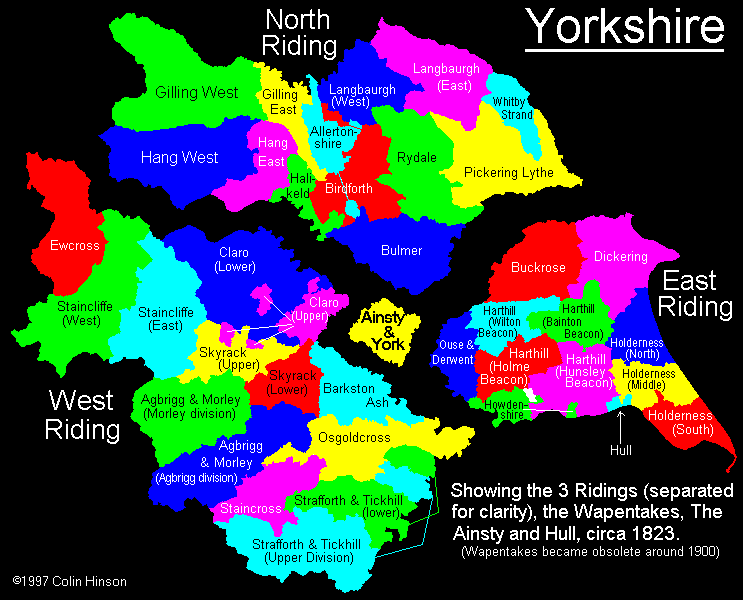
- Here is a map showing the wapentakes for the county.
You can see maps centred on OS grid reference SE271397 (Lat/Lon: 53.85283, -1.589519), Adel which are provided by:
- OpenStreetMap
- Google Maps
- StreetMap (Current Ordnance Survey maps)
- Bing (was Multimap)
- Old Maps Online
- National Library of Scotland (Old Ordnance Survey maps)
- Vision of Britain (Click "Historical units & statistics" for administrative areas.)
- English Jurisdictions in 1851 (Unfortunately the LDS have removed the facility to enable us to specify a starting location, you will need to search yourself on their map.)
- Magic (Geographic information) (Click + on map if it doesn't show)
- GeoHack (Links to on-line maps and location specific services.)
- All places within the same township/parish shown on an Openstreetmap map.
- Nearby townships/parishes shown on an Openstreetmap map.
- Nearby places shown on an Openstreetmap map.
- The following places are within the boundaries of this (ancient) parish, but I have no further information on them other than the Ordnance Survey Landranger Grid reference shown:
- (SE258453) Arthington House
- (SE260404) Holt Park
- (SE255394) Tinshill
- (SE288438) Bank End
- (SE281437) Bank Side
- (SE273434) Bank Top
- (SE270422) Black Hill
- (SE267428) Breary Grange
- (SE260443) Creskeld Hall
- (SE236401) Moss House
- (SE306421) Owlet Hall
- (SE288452) The Nunnery
- This parish is covered (or partly covered) by the following Societies:
- A list of those paying the 1379 Subsidy Rolls (Poll Tax) for this parish.