
Hide
Bardsey
hide
Hide
hide
Hide
Hide
The Ancient Parish of BARDSEY
[Transcribed information mainly from the early 1820s]
"BARDSEY, a parish-town, in the lower-division of Skyrack; 4 miles from Wetherby and Harewood, 4 miles N. from Leeds, 19 from York. Pop. including East Rigton, 336, which being united, form a township. The Church is a vicarage, dedicated to All-Saints, in the deanry of the Ainsty, value, ~£4. 1s. 8d. p.r. £150. Patron, Geo. Fox, Esq.The church of Bardsey affords a fine specimen of the Norman architecture, but not to be compared to Adel, although from the engravings given of both in Loidid et Elmete, we might suppose they were equally perfect. On the north side of the village, and near to the Grange, are large earth works of some ancient castle.
This place was born the celebrated William Congreve, the poet, and whose baptism is thus registered:- "William, the sonne of Mr. William Congreve, of Bardsley Grange, was baptised, February 10th, 1669."
He wrote the "Old Batchelor," the "Double Dealer," "Love for Love," the Mourning Bride, the "Way of the World," and some poems."
"EAST RIGTON, in the township of Rigton with Bardsey, and parish of Bardsey, lower-division of Skyrack; 4 miles from Wetherby, 5 from Harewood, 8 from Leeds. Pop. included in Bardsey."
"WIKE, in the parishes of Harewood and Bardsey, upper-division of Skyrack; 2 miles S. of Harewood, 6½ from Leeds, 8 from Wetherby. Pop. 139."
"WOTHERSOME, 2 houses in the parish of Bardsey, lower-division of Skyrack; 5 miles S. of Wetherby, 5½ from Tadcaster. Pop. 16."
[Description(s) edited from various 19th century sources by Colin Hinson © 2013]
Hide
- Here are photographs of Churches etc. in the parish:
- All Hallows Church, Bardsey (view 1).
- Internal view looking down the nave
- The Side Chapel
- All Hallows Church, Bardsey (view 2).
- The Roman Catholic Church, Bardsey.
- All Hallows Church, Bardsey (view 1).
- Transcript of the entry for Bardsey in the "Collections relative to Churches and Chapels".
- The whereabouts and dates of the Registers etc. for the Parish of Bardsey.
- The List of Incumbents of All Hallows Church, Bardsey.
- Transcript of the entry of "professions and trades" in the Baines's Directory and Gazetteer, Vol I, West Riding.
- There is further information about this parish from the National Gazetteer 1868, Yorkshire extracts.
- There is further information about this parish from the Lewis's Topographical Dictionary of England, Yorkshire extracts.
- Ask for a calculation of the distance from Bardsey to another place.
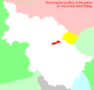
- For a detailed map of this parish see this parish boundaries map.
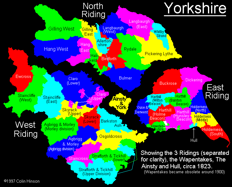
- For a more detailed map of the parishes in the riding please see the Yorkshire parish maps page.
- For a more detailed map of the county please see the Yorkshire map page.
- Here is a map showing the wapentakes for the county.
You can see maps centred on OS grid reference SE365432 (Lat/Lon: 53.883712, -1.446214), Bardsey which are provided by:
- OpenStreetMap
- Google Maps
- StreetMap (Current Ordnance Survey maps)
- Bing (was Multimap)
- Old Maps Online
- National Library of Scotland (Old Ordnance Survey maps)
- Vision of Britain (Click "Historical units & statistics" for administrative areas.)
- English Jurisdictions in 1851 (Unfortunately the LDS have removed the facility to enable us to specify a starting location, you will need to search yourself on their map.)
- Magic (Geographic information) (Click + on map if it doesn't show)
- GeoHack (Links to on-line maps and location specific services.)
- All places within the same township/parish shown on an Openstreetmap map.
- Nearby townships/parishes shown on an Openstreetmap map.
- Nearby places shown on an Openstreetmap map.
- The World War I and II Memorial Plaque in All Hallows Church, Bardsey.
- The following places are within the boundaries of this (ancient) parish, but I have no further information on them other than the Ordnance Survey Landranger Grid reference shown:
- (SE364418) Bracken Park
- (SE360438) Rigton Grange
- (SE376447) Rigton Hill
- (SE387428) Stubbing Moor House
- This parish is covered by the following Society:
- A list of those paying the 1379 Subsidy Rolls (Poll Tax) for this parish.