Hide
Barwick In Elmet
hide
Hide
hide
Hide
Hide
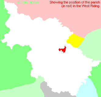
The Ancient Parish of BARWICK IN ELMET
[Transcribed information mainly from the early 1820s]
"BARWICK IN ELMET, a parish-town, in the lower-division of Skyrack, liberty of Pontefract; 7 miles from Tadcaster and Wetherby, 8 from Leeds, 16 from York. Pop. 1,481. The Church is a rectory, dedicated to All-Saints, in the deanry of the Ainsty, value, £33. 12s. 6d. Patron, the King, as Duke of Lancaster.This place is said to have been the seat of the Kings of Northumberland, and Whitaker's Loidis and Elmete supposes it to have been founded by the great Edwin; "the great extent and magnificence of this fortification, which is four furlongs in circumference, and contains an area of more that thirteen acres, sufficiently prove that it has been a royal work." The mount, called Hall Tower Hill, hath been encompassed by a double trench; on this mount most probably stood the royal mansion: it is now the only part that remains. This manor was afterwards part of the possessions of the Lacys; Roger de Lacy having married the sister of William de Vesey, Rector of the parish. From the Lacys it descended to the Dukes of Lancaster, to which duchy it has been ever since annexed.
Elmet was not conquered from the Britons till Edwin's reign, in 560, by the Saxons. --Turner's Anglo Saxons."
Information on the following places in this Parish is contained on a supplementary page.
|
|
[Description(s) edited from various 19th century sources by Colin Hinson © 2013]
Hide
- There is a list of cemeteries (as opposed to Church Graveyards) which includes Whinmoor on the Leeds City Council's website.
- Here are photographs of Churches etc. in the parish:
- All Saints' Church, Barwick in Elmet (view 1).
- All Saints' Church, Barwick in Elmet (view 2).
- The Methodist Church, Barwick in Elmet. (The Church's website is here.)
- The Methodist Church, Cross Gates.
- St. Theresa's Roman Catholic Church, Cross Gates.
- St. John's Church, Roundhay (view 1). (With short history). (The Church's website is here.)
- St. John's Church, Roundhay (view 2).
- Roundhay Methodist Church, Roundhay. (The Church's website is here.)
- The Christadelphian Hall, Oakwood.
- St. Philip and St. James's Church, Scholes.
- The Methodist Church, Scholes.
- The Methodist Church, Stanks.
- Christ Church, Stanks.
- The Baptist Church, Swarcliffe.
- St. Luke's Church, Swarcliffe.
- St. Gregory's Roman Catholic Church, Swarcliffe.
- The following Churches have their own websites:
- St. Edmund's, Roundhay.
- Caroline Freeman has written a short history and about the present state of St. John's, Roundhay.
- Transcript of the entry for Barwick in Elmet in the "Collections relative to Churches and Chapels".
- Transcript of the entry for Roundhay in the "Collections relative to Churches and Chapels".
- The whereabouts and dates of the Registers etc. for the Parish of Barwick in Elmet.
- The whereabouts and dates of the Registers etc. for the Chapelry of Roundhay.
- Transcript of the entry of "professions and trades" in the Baines's Directory and Gazetteer, Vol I, West Riding.
- Transcript of the entry of "professions and trades" in the Pigot's 1834 Directory, Yorkshire section.
- There is further information about this parish from the Pigot's 1834 Directory, Yorkshire section.
- There is further information about this parish from the National Gazetteer 1868, Yorkshire extracts.
- There is further information about this parish from the Lewis's Topographical Dictionary of England, Yorkshire extracts.
- There is further information about this parish from the Stephen Whatley's Gazetteer 1750, Yorkshire extracts.
- Ask for a calculation of the distance from Barwick In Elmet to another place.

- For a detailed map of this parish see this parish boundaries map.
- For a more detailed map of the parishes in the riding please see the Yorkshire parish maps page.
- For a more detailed map of the county please see the Yorkshire map page.
- Here is a map showing the wapentakes for the county.
You can see maps centred on OS grid reference SE397373 (Lat/Lon: 53.830452, -1.398297), Barwick In Elmet which are provided by:
- OpenStreetMap
- Google Maps
- StreetMap (Current Ordnance Survey maps)
- Bing (was Multimap)
- Old Maps Online
- National Library of Scotland (Old Ordnance Survey maps)
- Vision of Britain (Click "Historical units & statistics" for administrative areas.)
- English Jurisdictions in 1851 (Unfortunately the LDS have removed the facility to enable us to specify a starting location, you will need to search yourself on their map.)
- Magic (Geographic information) (Click + on map if it doesn't show)
- GeoHack (Links to on-line maps and location specific services.)
- All places within the same township/parish shown on an Openstreetmap map.
- Nearby townships/parishes shown on an Openstreetmap map.
- Nearby places shown on an Openstreetmap map.
- The World War I and II War memorial in Barwick in Elmet
- The following places are within the boundaries of this (ancient) parish, but I have no further information on them other than the Ordnance Survey Landranger Grid reference shown:
- (SE377377) Arthursdale
- (SE371360) Barnbow Carr
- (SE346369) Beechwood
- (SE400395) Kiddal Lane End
- (SE315380) Lidgett Park
- (SE348376) Monkswood
- (SE374352) Pendas Fields
- (SE371392) Sandhills
- (SE364361) Swarcliffe
- (SE352380) Wellington Hill
- (SE361367) Whinmoor
- The Barwick-in-Elmet Historical Society was established in 1984 to research, record, and publish the history of the parish from the earliest to recent times.
- This parish is covered by the following Society:
- A list of those paying the 1379 Subsidy Rolls (Poll Tax) for this parish.

